Goat Island is made up of dolostone bedrock covered with glacial deposits. For thousands of years, these deposits lay under deep lake and river waters. About 3,500 years ago, the water level of the Upper Niagara began to drop, eventually exposing the deposits forming Goat Island. Goat Island has only been part of the Niagara River Corridor’s landscape for about 500 years. The combination of the mist from the falls and fertile soil made Goat Island the site of what was a very special forest that included the largest variety of shrubs and trees in North America.
So how fast do the Niagara Falls erode?
Here's a cross-section of the geology at the falls. There is one important rock formation here - the Lockport Dolostone (also called Dolomite) which is underlain by a few different sandstone and shale units.
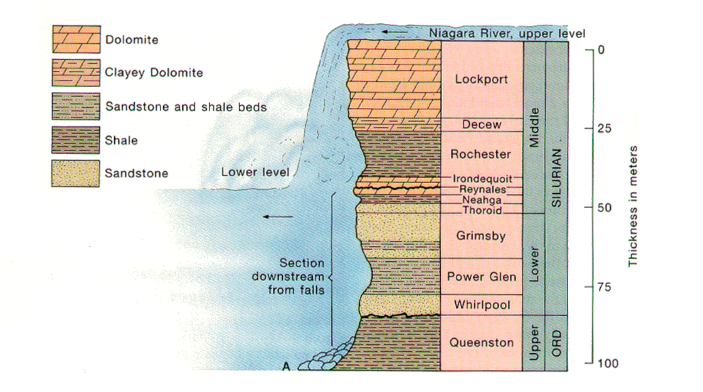
Dolostone is similar to limestone. Limestone, a very common sedimentary rock, is made of the mineral calcite - CaCO3 (calcium carbonate). Dolostone, on the other hand, is basically limestone with some magnesium substituting for the calcium in the formula (which creates the mineral dolomite) - CaMg(CO3)2. This generally makes it a harder, more resistant rock than limestone. The shales underneath are much softer and more easily eroded.
Since the Lockport Dolostone is so hard and resistant, and is slightly tilted (dipping to the south), it doesn't weather as much as the surrounding shales and erodes to form a prominent cliff called the Niagara Escarpment. We're only concerned with the escarpment where it crosses the Niagara River between Ontario, Canada and New York State (note the dipping Lockport layer in the picture below).
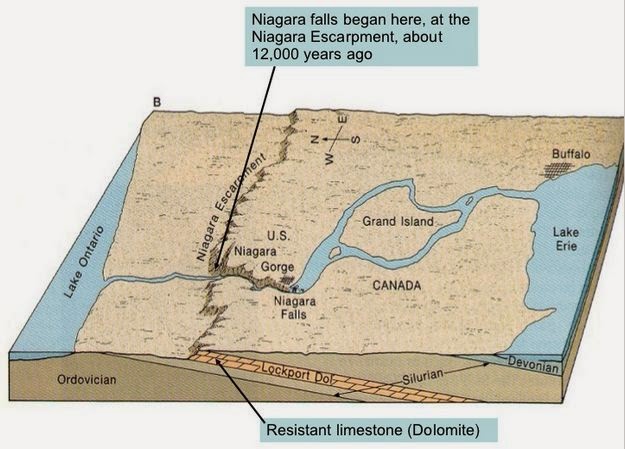
The Great Lakes and Niagara River formed after the most recent Ice Age. Basically, Niagara Falls formed at the Niagara Escarpment around 12,300 years ago and has been eroding upstream since then carving the Niagara Gorge through the Lockport Dolostone. The Dolostone ledge forms the resistant caprock to the falls. Without this resistant rock unit, the Niagara River would descend from Lake Erie to Lake Ontario in a more gentle slope with no major waterfalls.
So how fast is it currently eroding?
In 1905, Grove Karl (G.K.) Gilbert, who worked for the United States Geological Survey (USGS), studied the rate of recession at the falls since Hall's measurements by resurveying the falls, and came up with an average rate of 5.3 feet/year.
This rate, however, drastically slowed over the 20th century. The building of huge hydroelectric power plants in both the U.S. and Canada means that anywhere from one-half (daytime) to two-thirds (nighttime) of the water in the river about Niagara Falls is diverted away for power generation. Today, the average rate of erosion is estimated to be less than 1 foot per year (0.3 m/yr).
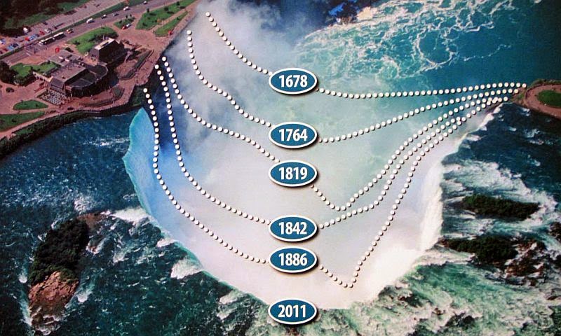
Here's a diagram showing erosion of the Canadian Horseshoe falls over the past few hundred years (both estimated and directly measured). It's noticeably fast.
As you can see by looking at a map of the falls (or an aerial view), the reason there are two waterfalls currently is because the falls have intercepted Goat Island with the Canadian Horseshoe falls on one side and the American falls on the other.
Prior to 600-800 years ago (depending on the exact rates of erosion), there was only one waterfall on the Niagara River. In a couple of thousand years, after erosion moves the waterfalls up past Goat Island, the two falls will again merge into one (really, what will happen is that the Horseshoe falls, which is eroding much faster will move past Goat Island leaving the slower American Falls behind, high and dry). With the island diverting the water, it creates an interruption in the flow rate of the water. A sort of water “speed bump” is helping reduce the rate of erosion from the large volume of water.
After about 15,000 years, the falls will have moved far enough upstream that it will lose the resistant caprock, only cutting through shale (Salina Shale). This will turn it into a series of rapids and we'll lose the spectacular waterfall.
So why has the erosion process slowed down? Goat Island plays a big role in this. Water is diverted at the head of the island. 90% of the water goes to the Canadian side and 10% goes to the American side. So this means the American side of the falls will erode at a lesser rate. The rock talus at the base of the American Falls was left to the forces of nature. It was decided that to remove the talus would be too expensive and create too much of an artificial look. The water flowing over the American Falls is too little to erode the talus so it will be there until the American Falls remains as it is.
Today, through increased water diversion and anti-erosion remedial steps, the rate of recession at the Horseshoe Falls has been reduced to a fraction of what it used to be. Today it is estimated that erosion of the Horseshoe Falls is less than one foot per year. In the future, through remedial efforts and further water diversion that the amount of erosion at the Horseshoe Falls has been projected to be reduced to approximately 1 foot every 10 years.
Today, erosion of the American Falls is estimated at 3 – 4 inches every 10 years. The water flow which is regulated at a minimum level of 10% of the estimated 100,000 cubic feet per second during the summer (50,000 cubic feet per second during winter) is insufficient to cause major erosion.
To get credit for this earthcache, send the answers to the following questions to my account:
- How many years have elapsed since the waterfall was at the Niagara Escarpment?
- What is the name of the top layer of bedrock that creates the falls?
- Explain in your own words why Goat Island is helping slow the erosion rate.
- Go to the posted coordinates and view where the water diverts around the island. Which side seems to be flowing faster?
- Explain your reason for answer #4.
- Post a picture of yourself (face not required) or a personal item at the “speed bump”.
source: Hudson Valley Geologist