Lina Myr – en intressant plats från geologiskt och biologiskt perspektiv.
Lina Myr är belägen i en sänka i den Gotländska berggrunden som under årtusendena sedan istiden byggts upp successivt lager för lager där de djupaste lagren bildades direkt efter det att inlandsisen dragit sig tillbaka för cirka 11500 år sedan då Baltiska issjön bildades. För 8300 år sedan övergick Baltiska issjön till Yoldiahavet när en öppning mot havet bildades i nuvarande Mellansverige som trots sitt namn endast höll bräckt vatten. Landhöjningen ledde sedan till att Yoldiahavet övergick till Ancylussjön för 7500 år sedan. För cirka 6000 år sedan öppnades återigen förbindelsen mot havet, denna gång söder om nuvarande Skåne och Littorinahavet bildades. Littorinahavet hade sin strandlinje utefter östra kanten på det som idag är Lina Myr. Detta havet fick sitt namn från snäckan Littorina littorea som man kan hitta rester av i lerlagret direkt under torven i Lina Myr. Efterhand gjorde landhöjningen att havet trängdes bort och den våtmark som lade grunden till Lina Myr bildades. Detta ledde till ett torvlager som före utdikningen i 1900-talets början var mellan 10 och 13 meter över havet, men efter utdikningen har nivån sjunkit till endast 9 meter över havet.
Figur 1 - Havsytan för cirka 7000 år sedan.
Vid östra kanten av Lina Myr är det en långsträckt brant som håller en stor mängd grus (På ett ställe är det 22 meter grus innan berggrunden anträffas, detta framkom vid en brunnsborrning) och som längre österut övergår i berghäll under ett relativt tunt jordlager där berggrunden i vissa fall går i dagen eller återfinns efter några få decimeter.
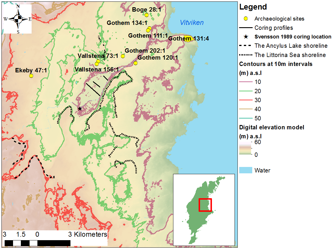
Figur 2 - Geologin runt Lina Myr
Namnet Lina eller Line är mycket gammalt och sägs betyda sluttning eller slänt:
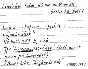
Figur 3 - Förekomst av namnet Lina i formen Lijna.
Källmaterial:
Cachen återfinns 150 meter från parkeringen väster om vägen i riktning mot Gothem. Inga staket behöver forceras, använd körvägen.
Lina Mire – an interesting place from both a geological and abiological perspective.
The Lina Mire is located in a depression in the rock bed of Gotland that during the millenia since the ice age has built up layers of silt, clay and peat where the deepest layers were formed directly after the ice age glacier retracted about 11500 years ago when the Baltic Ice Lake was formed. At about 8300 years ago the Baltic Ice Lake changed into the Yoldia Sea when an opening was created to the ocean in what today is middle Sweden. The Yoldia Sea was a brackish water sea. This sea changed into the Ancylus Lake about 7500 years ago when the land raising cut off the middle Sweden passage. About 6000 years ago the connection to the ocean was re-established, this time south of Skåne and that did lead to the establishement of the Littorina Sea. The Littorina Sea had the shore line at what is now the east border of the Lina Mire. This sea got the name from Littorina littorea which can be found in the clay layers below the peat in the Lina Mire. Subsequent land rise caused the sea to be evicted and did lead to the marsh land that was the base for the Lina Mire formation. During the millennia after that a peat layer was formed that was in the range between 10 and 13 meters above sea level, but after the draining of the mire the level has now fallen to only 9 meters.
Figure 1 – Sea level about 7000 years ago.
At the eastern edge of the Lina Mire there is a long slope that contains a considerable amount of gravel (At one point there is 22 meters of gravel before the bedrock, this was found when drilling a well) and that further to the east transits into a bedrock just a few decimeters below the surface and even in some places is exposed.
Figure 2 - Geology around Lina Mire
The name Lina or Line is very old and is said to mean slope.
Figur 3 – Occurrence of the name Lina in the form Lijna.
The cache is found 150 meters from the parking to the west of the road in the direction towards Gothem. No fences has to be traversed, use the access road.