
Welcome to the Visit Conroe Texas GeoTour. Download and print your GeoTour passport and don't forget to get the code word in each cache, complete the passport, and turn in for a commemorative coin. You may also pickup a copy of the passport at the Visit Conroe office address listed below.
Whatever time of year brings you to the area, there are numerous activities to enjoy. Get your
Visit Conroe Visitor Guide here
Now for the Cache:
For millions of years, the geography of Texas has been shaped by marine waters and large river systems draining from the young Rocky Mountains southeastward across Texas toward the Gulf of Mexico. Major deltas fed by these rivers buried older marine deposits and prograded the coastline seaward into the Gulf of Mexico.
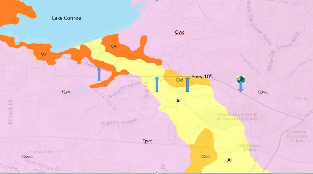
In recent geological times, the water sheds of the San Jacinto River, and the Lake Creek and Mound Creek tributaries that flow into the San Jacinto River have shaped Montgomery County. State Highway 105 transects several geological formations in the 5 mile stretch between its intersection with Loop 336 on the west side of Conroe and the southern end of Lake Conroe.
In spite of what may be perceived as just “flat land” throughout the Gulf Coast, there are many outcrops of various geological formations visible. These geological formations range from more than 20 million years in age - to areas in which depositions may have occurred in just the last few years, perhaps the result of a recent flood.
Four formations, primarily composed of unconsolidated to loosely consolidated sands and clays of varying grain sizes, are described in the paragraphs below. A map prepared by the US Geological Survey (USGS) (https://txpub.usgs.gov/dss/texasgeology/) of the surface geology along the referenced section of Hwy 105 in Montgomery County, with approximate viewing locations for this earthcache, is shown below:
You will make four stops just off Hwy 105 to view four different formations. There is a place to safely park off the busy highway at each waypoint. Additionally, if you proceed to each waypoint in the order listed below, it will minimize having to cross both directions of traffic on Hwy 105. Parking coordinates are provided for each stop and therefore, please DO NOT PARK on the shoulder of Hwy 105.
To fulfill the requirements to log this earthcache as a find:
1) Optional - take a photo of yourself (or your group) at one or more of the Waypoints, identify the Waypoint number, and include the photo(s) with your log; and,
2) Send an email to the Visit Conroe cache owner with a brief description of the rock and/or soils that you find at each of your 4 stops, with the description including the color and texture of the formations that you observed. Please do not include this information in your log.
Waypoint 1 (Posted Coordinates); Parking (N30 20.301 W095 31.086)
The Willis Formation (labeled “Qwc” on the map), Pleistocene in age, was deposited from 2.6 million years to 30,000 years ago. The Willis Formation is comprised of clay, silt, sand, siliceous granule to pebble gravel with some petrified wood and, in some sequences, sand coarser than that of younger units. Layers may be colored light gray, orange-brown, or orange which in turn may exhibit lenses of red, sandy silt and white to gray clay. The Willis Formation covers 49% of Montgomery County and can be easily viewed on an embankment on the north side of Hwy 150 at the posted coordinates.
Waypoint 2 (N30 20.965 W095 34.284); Parking (N30 20.952 W095 34.258)
The Flemming Formation (labeled “Mf” on the map), Miocene in age (23 million to 5.3 million years ago), covers about 13% of the surface area in Montgomery County. The Fleming Formation is primarily composed of clay and sandstone. The clays, sometimes calcareous, often form brownish-black soil. Sands are medium to coarse grained, calcareous and thick bedded, some with cross-bedding. Colors are light yellow-gray, which often weathers light-gray to medium gray, sometimes contains reworked Cretaceous invertebrate fossils. The thickness of this formation can be as much as 1200'.
Waypoint 3 (N30 20.525 W095 32.638); Parking at same coords.
Alluvium (labeled “Al” on the map), Holocene in age (the current geological epoch), has been continuously deposited in the last 10,000 – 12,000 years. Alluvium is thick accumulations of clay and silty, clayey fine to very fine-grained quartz sand and shell sand accumulations that were deposited on alternately dry and flooded barren flats. Alluvium comprises approximately 6% of the surface area in Montgomery County. Outcroppings of this formation can be viewed in grass-free areas along Pecan Bend Dr and near the Hwy 105 bridge that crosses the San Jacinto River. If the area has had some hard rain and large quantities of water are being released from Lake Conroe, you will possibly be unable to reach these exact coordinates due to high water. In this scenario, however, you might be able to witness alluvial deposition in action!
Waypoint 4 (N30 20.541 W095 31.897); Parking at same coords.
The Deweyville Formation (labeled as “Qd” on the map), also Pleistocene in age, was deposited 30,000 to 11,700 years ago and is characterized by unconsolidated layers of sand, silt, clay, and gravel locally indurated with calcium carbonate (caliche). The Deweyville Formation covers approximately 2% of Montgomery County. The Deweyville Formation can be viewed along the sides of a stream that runs along Ballard Circle, just as you turn off Hwy 105.
Redeem Completed Passport:
Please email a picture of your completed passport to visitconroegeotour@gmail.com to receive your Conroe Geocoin!
#GeoConroe