This Earth Cache is about the geology of the Maitland Coastal Nature Reserve and surrounding area. Do not go to the published coordinates. To answer the questions you will have to follow the de Stades trail and visit the two waypoints.
EDUCATIONAL LOGGING REQUIREMENTS
In order to substantiate your visit and comply with the educational requirement for Earth Caches you have to submit your answers to the following questions to the cache developers via their profile or messaging:
For purposes of logging this cache you must answer the following two questions.
TO LOG THIS CACHE AND QUALIFY you need to answer the following questions in an email or message to the cache owner via our profile on the geocaching website. Any logs not accompanied by an email will be deleted.
1) What rock can be found at Waypoint 1?
2) What rock can be found at Waypoint 2?
3) Pictures would be good but are not a requirement.
|
The Technical Explanation
Skip to the task below if you get confused after reading a few paragraphs
The geology of the area is indicated on the 1: 250 000 sheet 3324 Port Elizabeth. The coastal belt here is overlain by unconsolidated Holocene aeolian sands of the Schelm Hoek Formation (Qw). Inland, on the higher ground these give way to the older (Plio-Pleistocene) dune sands of the Nanaga Formation (T-Qn). Both these coastal units belong to the upper part of the Late Cenozoic Algoa Group.
The topography appears to be structured by low, WSW-ENE trending aeolian palaeodune crests of the Nanaga Formation. The coastal aeolianites (ancient or “fossil” dune sands) of the Nanaga Formation of Pliocene to Early Pleistocene age crop out extensively to the west of Port Elizabeth. They comprise calcareous sandstones and sandy limestones showing large scale aeolian cross- bedding and may reach thicknesses of 150m or more. The Nanaga aeolianites are typically partially to well-consolidated, although unconsolidated sands also occur west of Port Elizabeth. The upper surface of the aeolianites weathers to calcrete and red, clay-rich soil. The age of the palaeodunes decreases towards the modern coastline, reflecting marine regression (relative sea level fall) during the period of deposition. The more highly elevated, inland outcrops may even be Miocene in age. Typically the ancient dunes are preserved as undulating ridges of rounded hills trending parallel to the modern shoreline.
Modern aeolian sands of the Schelm Hoek Formation (Algoa Group) (Qw) are still active dune sands of Holocene age (last 6500 years). They may be up to 100m thick with an average of 30m, and extend up to 6km from the coast. In addition to unconsolidated, well sorted, calcareous aeolian sands the Schelm Hoek Formation contains abundant shell middens of the Late Stone Age.
Late Precambrian metamorphosed bedrock of the Kleinrivier Formation (Nk) within the Gamtoos Group crop out in the region along the lower course of the Maitlands River as well as all along the coast from Beach View southeastwards towards Red Rock and beyond. These highly deformed Precambrian metasediments underlie the veneer of Algoa Group sediments on the coastal plain here. The Gamtoos Group rocks are among the oldest mapped in the Eastern Cape Province and typically weather at surface to reddish soils. The Kleinrivier Formation metasediments consist largely of yellowish grey phyllites with subordinate grits, arkoses, quarzites and conglomerates. They show several phases of deformation, intense folding, shearing and thrusting, low grade metamorphism and a well developed cleavage.
Postulated depositional settings range from alluvial fans to shallow marine shelf and offshore submarine fans, with the last most applicable to the pelitic Kleinrivier Formation. Quartz-calcite veins in dolomitic limestones of the overlying Kaan Formation were mined for lead, silver, zinc and copper at Maitland Mine along the Maitland River to the northwest of the study area in the 1920s.
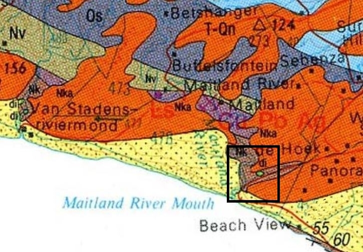
Geological map of an area near Maitland Coastal Nature Reserve. The black square indicates the area in which the reserve falls. The main geological units are: Nk (brown) = Kleinrivier Formation (Gamtoos Group), T-Qn (orange-brown) = Plio -Pleistocene dune sands of the Nanaga Formation (Algoa Group) Qw (pale yellow) = Holocene aeolian sand of the Schelm Hoek Formation
The More Simple Task
Geology is a complex subject and the technical terms make it even more complex. Most of the bedrock on the trails is covered by top soil and dense coastal forests and is not visible. To make the task for this Earth Cache all you need to do is to identify two common rock types that you will see, calcrete and quartz
Calcrete is formed when the shells in the sand are slowly dissolved by ground water. Changes in the soil chemistry cause dissolved calcium carbonate leached from the shells to be precipitated as layers of calcrete. In other words calcrete is a layer of soil or sediment in which the particles have been cemented together by the precipitation of mineral matter (calcuim carbonate) into the spaces between the particles.
Calcrete can be a very hard, dense, heavy, and durable material if it is firmly bound by a cement that completely fills the interstitial voids between the soil or sediment particles. It can also be a weak and friable material if it is poorly cemented.
Quartz is an essential constituent of granite, felsic igneous rocks and is very common in sedimentary such as sandstone and shale and is also present in variable amounts as an accessory mineral in most carbonate rocks. Because of its resistance to weathering it is very common in stream sediments and in residual soils.
While the majority of quartz crystallizes from molten magma, much quartz also chemically precipitates from hot hydrothermal veins. The simplest type of a quartz vein is the filling of an already present crack in rocks caused by the cooling and shrinking of rock, or tectonic events. Hot brines that percolate the rocks and will precipitate the minerals they carry with them in cracks at lower temperatures and pressures. Hot brines that enter a crack in the rock from some distant hot source like a granite pluton first cool and precipitate most of their load rather quickly. The result is milky quartz. Later, when the crystal growth slows down, the crystals may get less milky or even clear. In the majority quartz veins, most of the quartz is precipitated as massive, milky quartz, and well-formed crystals, if found at all, are only a small portion of the vein filling.
References:
Map - 1:250 000 sheet 3324 Port Elizabeth, Council for Geoscience, Pretoria
The geology of the Port Elizabeth – Uitenhage area - F G le Roux
Palaeontological Impact Assessment - Desktop Study - John E Almond
Field guide to the Eastern and Southern Cape coasts By Roy Lubke & Irene De Moor
Department of Mining Engineering, FE, NUOL