Please note that the Earth Cache is in Hobby Park and a day visitors fee and /or a 4x4 Trail fee is applicable.
The View
The listed coordinates bring you to a spectacular viewpoint on top of a ridge overlooking the Walter Sisulu Botanical Gardens. From this viewpoint you can see the upturned 2 950-million-year-old Orange Grove Quartzite with a view to the north and east which overlooks the Johannesburg Dome, a major geological formation.
The topography of Johannesburg is distinctive with the rocky mountainous ridges and the line of koppies that runs from east to west. These are the quartzite ridges of the famous Witwatersrand. The geology is unique. Viljoen and Reimold (An Introduction to South Africa’s Geology and Mining Heritage) make the point that this is one of the few localities where the evolution of the granitic crust of Southern Africa has been preserved and can be viewed. There are several places in Johannesburg where approximately 500 million years of the Earth’s history is exposed and displayed.
From this viewpoint one sees a layering of hard quartzite rock and sediments of shale, within the Witwatersrand super group.
The Witwatersrand
One thinks of the Highveld as being on a high flat plateau at the centre of Gauteng, but in fact the wider area is an area of ridges, giant rocks, outcrops, cuttings, randte, dips, krantzes, gullies, kloofs, sluite and koppies. (Kathy Munro -Three Historic Johannesburg Passes)
The rocks that make up the Witwatersrand Ridge dip downwards and southwards to form the largely underground “Witwatersrand Basin” which covers an elliptical area with a 300 km long major axis from Evander in the north-east to Theunissen in the south-west, and 150 km wide stretching from Steynsrus in the south-east to Coligny in the north-west, with a small subsidiary basin at Kinross.
The Witwatersrand Basin is a largely underground geological formation which surfaces in the Witwatersrand. The entire series of rocks, known as the “Witwatersrand Supergroup’’ consists of quartzites, banded ironstones, mudstones, tillites, conglomerates and some marine lava deposits. Most of the basin is deeply buried under younger rocks, but outcrops occur in Gauteng, the Free State, as well as in some of the surrounding Provinces. The outcrop in Gauteng forms the Witwatersrand ridge, from which the basin and its rocks derive their name.
The Witwatersrand basin was laid down in two stages, over the course of 260 million years starting just short of 3000 million years ago. The first phase, lasting 60 million years, consisted of sedimentary deposits in a shallow sea, conveniently named the “Witwatersrand Sea”. The resulting 2500–4500 m thick layer of sediments is termed the “West Rand Group” of Witwatersrand rocks. The second phase, which lasted for 200 million years, followed on from the first phase, with on-land deposits, resulting from the retreat of the Witwatersrand Sea, leaving a wide almost flat coastal plain over which rivers from the north formed wide braided river deltas. The resulting 2500 m thick layer of rock is termed the “Central Rand Group”. The “West Rand Group” and “Central Rand Group” of rocks together form the “Witwatersrand Supergroup”, the full horizontal extent of which is termed the Witwatersrand Basin.
The floor of this newly formed “Witwatersrand sea” consisted of smoothly eroded granites. Sandy sediments brought in by rivers from the north started being deposited on the granite about 2970 million years ago. This sandy layer eventually became compressed to form the Orange Grove Quartzite, the lowermost layer of the Witwatersrand Supergroup. This quartzite layer can be seen lying on its granite base in Johannesburg, where it forms a 56 km long east-west ridge over which several rivers running to the north form waterfalls, giving rise to the name Witwatersrand.
Meteor Impact
By Oggmus - Own work, CC BY-SA 4.0, https://commons.wikimedia.org/w/index.php?curid=38939789
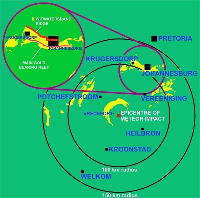
An event that had a major impact on the geology of the Witwatersrand Basin and its exposure in the Johannesburg region, was a massive meteor impact 110 km to the south-west of Johannesburg 2020 million years ago. The epicentre of the impact was close to the present village of Vredefort, which has given its name to the geological remnant of this immense event: the Vredefort Dome. Not only are the remains of this impact the oldest on earth, but it is also the largest meteor impact that has left its imprint on the earth’s geology of today.
A meteor 10–15 km across created a 300 km diameter crater, distorting all the rock strata within that circle. Johannesburg is just within the outer edge of this impact crater. In the immediate vicinity of the impact all the subterranean strata were uplifted and upturned, so that Witwatersrand rocks are exposed in an arc 25 km away from the impact centre.
The meteor impact, lowered the Witwatersrand basin inside the crater and brought it to the surface close to the crater rim, near Johannesburg, In fact, apart from the Witwatersrand outcrops (i.e. where these rocks are exposed at the surface) in the immediate vicinity of the Vredefort Dome, virtually all the other outcrops occur in an arc approximately 80–120 km from the centre of the impact crater, to the west, north-west, north and north-east. (Refer Wikipedia.org/wiki/Witwatersrand_Basin)
Questions
In order to qualify to log this cache, you need to answer the following questions and e-mail the cache owner. Any logs not accompanied by an email will be deleted.
1) Take a photo of you and your GPSr at this spot with the outcrop visible and include in your log [Optional].
2) Looking in a south eastern direction, how many distinct quartz veins can you identify leading down towards the Botanical Garden?
3) What caused the exposure of the quartzite layer of the Witwatersrand Supergroup in this area?
4) Which of the rocks of which the Witwatersrand Supergroup exists can you see / identify around ground zero?