
The Earthcache
Carrickarede Island near Ballintoy in County Antrim is a unique place in Northern Ireland to sink into the bowels of the earth.
Indeed it takes place on the mouth of one of the main volcanoes at the origin of the Antrim Plateau.
► Local geological context
The geology of the Antrim Plateau is dominated by important igneous rock areas.
Around 60 Ma (in early Tertiary times), great masses of molten rock were rising from the depth of the earth’s mantle. These nation-sized ‘lava-lamps’ are collectively considered to be a ‘hot spot’, now known as the ‘Iceland Plume’.
The rising magma spreads over great areas of what is now Northern Ireland, Scotland and the Faroes.

► Structure of an effusive volcano
The volcanoes that took place at the beginning of the Tertiary era in this region are effusive volcanoes.
These are named too ‘hot spot’ volcanoes or ‘accretion’ volcanoes. These ones emit fluid lavids generally basaltic in the form of flows.

This type this volcano includes two main compartments:
- The cone : it is the product of successive lava eruptions.
These more or less viscous liquid products, or lava, escape in flows from the emission mouth at temperatures ranging from 600 to 1200 ° C.
Depending on the rate of cooling, these lavas solidify into basalts (fast-cooling surface portion) or dolerites (slow-cooling deep portion).
- The mouth, named vent : this is where the lava escapes, but also solid projections, the pyroclastics.
At the end of its activity, these pyroclastics, at the end of volcanic activity, ended up accumulating in the mouth of the volcano, the latter having no more power to expel them.
► Rocks of cone
~ Basalt
Basalt is a volcanic magma rock from a rapidly cooled magma. This is is a melanocratic rock with a holomelanocratic (dark to very dark) microlithic structure, which results from the partial melting of the terrestrial mantle of peridotitic composition.
Cooling soon after its emission, the basaltic flow solidifies and contracts by forming basaltic organs, longitudinal basalt blocks with hexagonal section of decimetric order.

~ Dolerite
Dolerite has a composition similar to that of basalt but is characterized by higher crystal sizes (microgranular structure).
These are magmatic rocks intermediate between basalts and gabbros.
The dolerites therefore correspond to a slower cooling than that of the basalts. This explains their particular structure, called doleritic, which shows in a more or less microgranular paste, well expressed large grains of plagioclase, augite and, sometimes, olivine.

► The pyroclasts of the vent
The pyroclasts come from the solidified lava or are torn from the walls of the chimney and the crater by the rise of the magma. We classify them according to their dimensions.
- Blocks and bombs are the biggest items (more than 10 cm in length).
The blocks, angular, are projected in the solid state. The bombs are shreds of magma released in a more or less pasty state, solidifying in the air or on the ground.

- The slag is a fragment of lava that has solidified in the air during an explosive volcanic eruption. Measuring between 5 and 10 cm, the slag has an irregular and porous appearance
- The lapilli correspond to small fragments of lava from 3 mm to 5 cm in diameter, these elements have an alveolar structure.

The pile of lapilli forms layers called pozzolana. It is a natural rock formed by basaltic volcanic slag (projections) or composition. Pozzolana is usually red or black, with all the intermediate hues.
► From the volcano to the island of Carrickarede
At Carrickarede, the ancient volcanic pipe has left dolerite, a tougher rock than basalt, which erodes more slowly.
Behind the dolerite, to the south, the vent is filled with pyroclastic rocks that break down more easily, mostly a coarse tuff agglomerate.
The combination of the hard rock out front and the softer rock behind, with long-term erosion by the waves, has eventually left this small island.

► Bibliographical sources
The Questions
Point 1 : N 55° 14.362 W 006° 19.962
Here you are just before the bridge, on the mainland. Observe the low side of the path (photo WP 1).
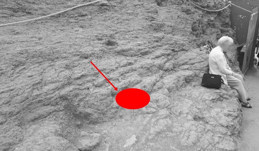
- Question 1 : Describe the structure of the outcrop. What do you see under the red zone ? Ddepending on its size, qualify this element.
Point 2 : N 55° 14.380 W 006° 19.934
You have just passed the suspension bridge, and here you are on the beginning of the island of Carrick-a-Rede.
Turn back (or answer this question when you return) and look at the cliff on the continent side to the left of the bridge.
- Question 2 : Describe this cliff and what makes it (a rather coherent rock or cluster of movable elements? Presence of big clasts? Etc ...).
Point 3 : N 55° 14.449 W 006° 19.904
Here you are in the upper part of the island. Go down the slope cautiously (without children!) and stop yourself in front of a rock outcrop of about 1.50 meters height.
- Question 3 : Describe the rock of this outcrop and deduce its nature.
- Question 4 : Look at the islet in front of you north-west side a hundred yards from Carrick-a-Rede. What form does the rock take on this island?
Point 4 : N 55° 14.432 W 006° 19.857
Here you are in the central part of the island on a small path; observe the elements making up the soil.
- Question 5 : Describe the elements forming the ground. Depending on its size, qualify these elements and the soil they compose.
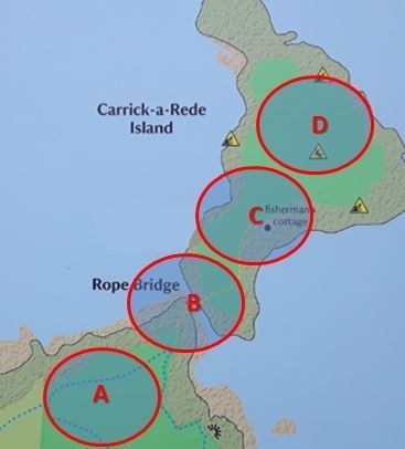
- Question 6 : According to the different observations that you realized at the different WPs, locate on the map below the place where the mouth of the volcano was 60 Ma ago (A, B, C or D).
You can log this cache without waiting for our confirmation,
but you must send us the answers at the same time, by e-mail via our profile (
fafahakkai) or by the system of Message Center of geocaching.com.
If there is a problem with your answers we will notify you.
The logs recorded without answers will be deleted.A photo of you or your GPS with the panoram in the background (not the WPs!) is welcome, but not mandatory.
Reminder concerning "Earthcaches": there is neither a container to look for nor a logbook to sign. One need only go to the location, answer to the differents questions and send us the answers.