About Waves:
Waves: Waves are a repeated movement in a body of water seen as an alternate rise and fall of the surface. Ocean waves may erode or deposit sediment on the beach. A ten-foot high wave is not uncommon during a major tropical storm or hurricane, and a few hours of big waves crashing on the coast can erode a lot of the beach—back to the dunes—or even farther. If the eroded sand is carried into deep water, the sediment is not available for the smaller waves to carry back to reconstruct the beach after the storm has passed. Unless additional sand is available, the post-storm shoreline will be established many feet inland of its former position before the storm.
The typical waves in OC are usually 4-6 feet. On a nice day, with almost no breeze, waves in OC can be 3-ish feet high.
A summary of waves
- There are 3 forces that form waves: wind, earthquakes (form tsunamis), and gravitational attractions between Earth, sun, and moon (form tides).
- Ocean waves are formed by the wind (friction between the wind and the water's surface).
- The size of a wave (fig. 1) depends upon the wind speed, length of time the wind blows in the same direction, and the distance over which the wind blows (fetch).
- Wind waves will continue as long as the wind is blowing. Once the wind stops the waves will continue until their energy is dissipated.
- Water particles in waves move in a nearly stationary circular motion (fig. 1).
- At the surface, the orbit of the water particles in a wave is about equal to the wave height. The orbits decrease in size downward through the water column to a depth of about one-half the wavelength
- Breaking occurs when the crest angle is less than 120º or steepness greater than 1/7.
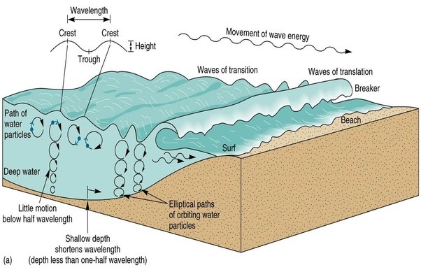
Figure 1. Ocean wave motion
Breaker Types: the slope of the lower beach depends on the type of waves (in beaches of uniform composition).
- Spilling Breaker: Gentle beach slope, waves break far from shore and surf gently rolls over the front of the wave.
- Plunging Breaker: Moderately steep beach slope, less steep wave, slightly longer period, wave curls over forming a tunnel until the wave breaks.
- Surging Breaker: Steep beach slope, a low wave of long period, doesn’t actually break, wave rolls onto the beach.
Longshore Currents:
Longshore Current: Sand moves to and from the beach in an onshore-offshore direction, but it also moves along the shoreline (“longshore”). This longshore sand transport is referred to as longshore drift (fig. 2), and because of it, beaches have been called “rivers of sand.” Longshore currents on the east coast typically move north to south than south to north like the Gulf Stream Current. There have been special instances of where the longshore currents have changed direction during storms, hurricanes, or an abrupt change of wind for a brief period of time. In March 2018, a tiny sandbar appeared next to the OC jetty’s south side which is closest to the inlet. This was caused by a change in the wind from the southwest. You can view the image of the beach https://d2wcro6av4bts2.cloudfront.net/wp-content/uploads/2018/03/inlet-beach1.jpg.
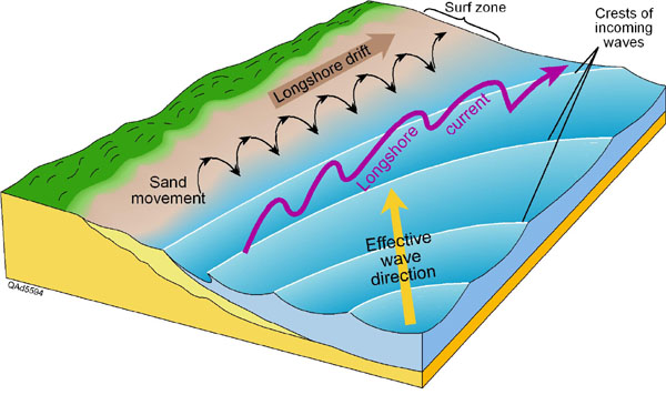
Figure 2. Schematic of longshore current.
The longshore current moves the sand along the beach. At a particular time, the longshore drift of the sand by the longshore current may be in either direction along the beach. Over the course of a year and at most locations, the volume of sand moved in one direction will exceed the amount moved in the opposite direction. The difference in the amounts of longshore drift between the two directions over a period of one year is called the annual net longshore drift. Knowing the annual net longshore drift is extremely important because the major source of sand for Ocean City’s beaches is from updrift beaches.
The ultimate sources of the sand for beaches are either new sand introduced to the coastal zone by rivers, old sand reworked by the waves and currents from deposits in shallow offshore areas.
The longshore current, the movement of water along the shoreline, is caused by
- Waves approaching at an angle to the shoreline.
- Tidal currents.
- Wind pushing water along the beach.
Beach Erosion:
Sand moves on and off the beaches seasonally. In the summer, sand moves onto the beach and is stored in dunes. During the winter months, sand migrates off the beach and into sandbars beyond the breakers. (fig. 3) The net direction of sand transport is from Delaware, in the northeast, to Virginia, in the southwest. Anything that interrupts the natural flow of sand will cause accelerated erosion. Additionally, Maryland's barrier islands are slowly migrating westward as sea level rises. Development on Fenwick Island has modified cycling of sand on Maryland's coast.

OC does not have a dune system anymore because of overdevelopment. In the past, development was permitted up to and beyond the natural primary dune line. This practice essentially removed seasonal dune storage from the cycle. Beach stabilization structures such as groins were placed along the beach to retard the southwestward movement of sand. Today Ocean City has built artificial dunes to complete the natural sand cycle in the area. Unfortunately, only northern OC has these dunes and the beaches by the inlet do not have this. To see the dunes, travel to 30th-146th street to see these new wonders.
Sand:
Sand is divided into five categories based on its size:
-Very fine sand (1/16 – 1/8mm)
-Fine sand (1/8 – 1/4mm)
-Medium sand (1/4mm – 1/2mm)
-Coarse sand (1/2mm – 1mm)
-Very coarse sand (1 mm – 2mm)
These are accurate measurements according to the Udden-Wentworth Scale
After reading the information above, please answer these required logging tasks:
- After reading A Summary About Waves, are OC’s waves spilling, plunging, or surging breakers.
- In the paragraphs about Longshore Currents, it says that the “major source of sand for Ocean City’s beaches is from updrift beaches.” If OC is getting sand from “updrift beaches,” what beaches are they? Hint: longshore currents run from north to south
- Go to the GZ and examine the sand on the beach (you may need to use a ruler and/or a magnifying glass to aid in your investigation). While looking at sand, estimate how many millimeters are most of the grains of sand and what category does OC sand fall into according to the scale above.
- As of June 2019, earthcaches are now allowed to have a required photo logging task. Please provide a photo of yourself, your GPSr, or a personal item that proves that you have visited this site. Please post this in your log.
Confirm your find by answering these questions on this Google Form or by sending your answers to us via message center.
*Please do not post your answers in your log!*
Enjoyed finding this EarthCache? Consider awarding it a favorite point!
Congrats to zurrobarnes for the FTF!
Check out Our Nearby Earthcaches!
 OCMD ~ A Flat Coast - Ocean City, MD
 Watch Out for the Rip Currents! 🌊 - Bethany Beach, DE
| We have earned GSA's highest level: |
 |