Vestige d'un strato volcan... EarthCache
Vestige d'un strato volcan...
Please note Use of geocaching.com services is subject to the terms and conditions
in our disclaimer.
Puei Griu ou Puy Griou .
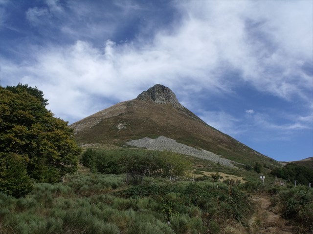 Le puy Griou est un sommet de 1 690 mètres d'altitude des monts du Cantal situé sur la ligne de crête entre les vallées de la Cère et de la Jordanne, à moitié sur les communes de Saint-Jacques-des-Blats et de Mandailles.
Le sommet est appelé Puei Griu en occitan aurillacois. Dans ce dialecte, griu vient de griea, qui signifie « pénible à monter »
Géologie...
Du fait de sa position au centre des monts du Cantal et de sa forme conique très élancée, le puy Griou a longtemps été présenté comme la cheminée érodée du volcan du Cantal. Mais il a depuis perdu ce rang et les géologues considèrent aujourd'hui qu'il s'agit d'un dôme de phonolite occupant certes une position centrale mais d'origine analogue à d'autres sommets du massif tels que le roc d'Hozières. Il se serait mis en place il y a environ 6 millions d'années, postérieurement aux phases éruptives paroxystiques qu'a connues le Cantal entre 8,5 Ma et 6,5 Ma2. Durant les périodes froides du Quaternaire récent, l'action répétée du gel et dégel a débité la roche en lauzes pour former un manchon d'éboulis.
On distingue plusieurs grandes périodes dans l’activité volcanique :
Les premières éruptions basaltiques (13 à 7 Ma).
Le puy Griou est un sommet de 1 690 mètres d'altitude des monts du Cantal situé sur la ligne de crête entre les vallées de la Cère et de la Jordanne, à moitié sur les communes de Saint-Jacques-des-Blats et de Mandailles.
Le sommet est appelé Puei Griu en occitan aurillacois. Dans ce dialecte, griu vient de griea, qui signifie « pénible à monter »
Géologie...
Du fait de sa position au centre des monts du Cantal et de sa forme conique très élancée, le puy Griou a longtemps été présenté comme la cheminée érodée du volcan du Cantal. Mais il a depuis perdu ce rang et les géologues considèrent aujourd'hui qu'il s'agit d'un dôme de phonolite occupant certes une position centrale mais d'origine analogue à d'autres sommets du massif tels que le roc d'Hozières. Il se serait mis en place il y a environ 6 millions d'années, postérieurement aux phases éruptives paroxystiques qu'a connues le Cantal entre 8,5 Ma et 6,5 Ma2. Durant les périodes froides du Quaternaire récent, l'action répétée du gel et dégel a débité la roche en lauzes pour former un manchon d'éboulis.
On distingue plusieurs grandes périodes dans l’activité volcanique :
Les premières éruptions basaltiques (13 à 7 Ma).
L’édification du stratovolcan (10 à 6,5 Ma).
L’effondrement du stratovolcan (autour de 7 Ma).
Des intrusions phonolitiques (entre 7 et 6,5 Ma).
Les basaltes supracantaliens (entre 7 et 2 Ma).
L'érosion glaciaire et post-glaciaire du volcan (entre 120 000 et 10 000 ans)
Aujourd’hui on trouve les dépôts trachyandésitiques sur un grand nombre de hauts sommets emblématiques du massif : Tous les Puys au nord et au sud du Plomb du Cantal (mais le culot sommital de celui-ci est en basanite, daté de -3 Ma) Le Puy de Peyre Arse et de nombreux Puys alentours (à l’exception des intrusions phonolithiques du Puy Griou) La crête de la Brèche de Rolland (Le Puy Mary est quant à lui un dôme de trachyte datant de 6,5 Ma).
Le Cantal est un stratovolcan alcalin intraplaque continental.
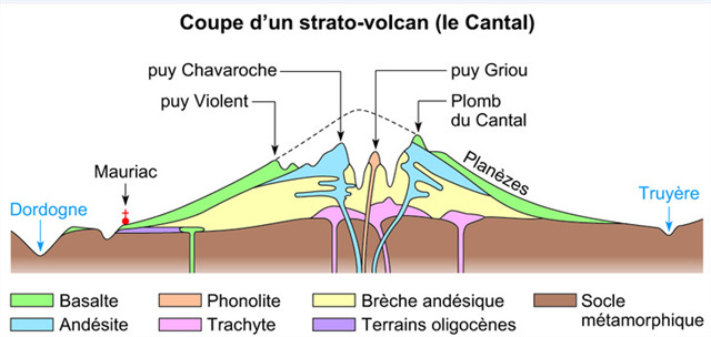 Il s'est édifié pour l'essentiel entre 13 et 3 Ma. Une petite zone centrale (8 à 10 km de diamètre), au relief accidenté de moyenne montagne (de 1300 à 1855 mètres d'altitude), où dominent brèches, intrusions et complexes filoniens. Les principaux sommets sont le Plomb du Cantal (1855 m), le Puy du Rocher (1813 m), le Peyre Arse (1806 m), le Puy Brunet (1806 m), le Puy Mary (1783 m) et le Puy Griou (1690 m). Ces sommets sont reliés entre eux par des lignes de crêtes dominant des cirques glaciaires d'où partent les principales vallées qui drainent le Cantal.
RAPPEL: PAS DE BOITE A TROUVER SUR PLACE...
POUR VALIDER LE FOUNDT-IT, REPONDEZ AUX QUESTIONS SUIVANTES:
1) De quand date (en MA) l'intrusion de la roche dominante ?
Il s'est édifié pour l'essentiel entre 13 et 3 Ma. Une petite zone centrale (8 à 10 km de diamètre), au relief accidenté de moyenne montagne (de 1300 à 1855 mètres d'altitude), où dominent brèches, intrusions et complexes filoniens. Les principaux sommets sont le Plomb du Cantal (1855 m), le Puy du Rocher (1813 m), le Peyre Arse (1806 m), le Puy Brunet (1806 m), le Puy Mary (1783 m) et le Puy Griou (1690 m). Ces sommets sont reliés entre eux par des lignes de crêtes dominant des cirques glaciaires d'où partent les principales vallées qui drainent le Cantal.
RAPPEL: PAS DE BOITE A TROUVER SUR PLACE...
POUR VALIDER LE FOUNDT-IT, REPONDEZ AUX QUESTIONS SUIVANTES:
1) De quand date (en MA) l'intrusion de la roche dominante ?
2) Le dôme du Puy Griou est constitué de quelle roche ?
3) Chaque pic alentour correspond à quoi dans cette multitude de volcans ?
4) Chaque planèze correspond à quoi ?
5) Noms des puys constitués d'un dôme similaire au Griou ?
6) Au WP, trouvez la roche en photo: (grattez-la et tapotez-la), que constatez vous ?
7) Photo optionnelle près du WP.
Loguez cette cache "Found it" et envoyez-moi vos propositions de réponses soit via mon profil, soit via la messagerie geocaching.com (Message Center), et je vous contacterai en cas de problème.
BONNE DECOUVERTE...Randonnée de 8 km A/R.
NE PAS MANQUER LA CACHE PROCHE: GC7WKCN PUY GRIOU de BlackHoot..
 Puei Griu ou Puy Griou.
The Puy Griou is a summit of 1690 meters altitude of the Cantal mountains located on the ridge between the valleys of the Cère and the Jordanne, half on the communes of Saint-Jacques-des-Blats and Mandailles.
The summit is called Puei Griu in Occitan Aurillacois. In this dialect, griu comes from griea, which means "painful to ride"
Geology ...
Because of its position in the center of the Cantal mountains and its very slender conical shape, the puy Griou has long been presented as the eroded chimney of the volcano of Cantal. But it has since lost this rank and geologists now consider that it is a phonolite dome occupying a central position but of similar origin to other peaks of the massif such as the rock of Hozières . It was set up about 6 million years ago, after the paroxysmal eruptive phases that Cantal experienced between 8.5 Ma and 6.5 Ma2. During the colder periods of the recent Quaternary, the repeated action of freezing and thawing has slashed the lauze rock to form a scree sleeve.
There are several major periods in volcanic activity:
The first basaltic eruptions (13 to 7 Ma).
The building of the stratovolcan (10 to 6.5 Ma).
The collapse of the stratovolcan (around 7 Ma).
Phonolitic intrusions (between 7 and 6.5 Ma).
Supracantal basalts (between 7 and 2 Ma).
Glacial and post-glacial erosion of the volcanic edifice (between 120,000 and 10,000 years ago)
Today we find the trachyandesitic deposits on a large number of high peaks emblematic of the massif: All the Puys north and south of the Plomb du Cantal (but the summit of it is in basanite, dated -3 Ma) The Puy de Peyre Ass and many surrounding Puys (with the exception of the phonolithic intrusions of Puy Griou) The crest of the Brèche de Rolland (The Puy Mary is a dome of trachyte dating from 6.5 Ma).
Cantal is a continental intraplate alkaline stratovolcan.
It was built mostly between 13 and 3 Ma. A small central area (8 to 10 km in diameter), the rugged terrain of mid-mountain (from 1300 to 1855 meters above sea level), dominated by breaches, intrusions and vein complexes. The main summits are the Plomb du Cantal (1855 m), Puy du Rocher (1813 m), Peyre Ass (1806 m), Puy Brunet (1806 m), Puy Mary (1783 m) and Puy Griou ( 1690 m). These summits are interconnected by ridges dominating glacial cirques from where the main valleys draining the Cantal.
REMINDER: NO BOX TO FIND IN PLACE ...
TO VALIDATE THE FOUNDT-IT, ANSWER THE FOLLOWING QUESTIONS:
1) 1) When (in MA) did the intrusion of the dominant rock occur?
2) The dome of Puy Griou is made up of what rock?
3) Every peak around is what in this multitude of volcanoes?
4) Each planet corresponds to what?
5) Names of puys made of a dome similar to Griou?
6) To the WP, find the rock in photo: (scratch it and tap it), what do you notice?
7) Optional photo near the WP.
Log this cache "Found it" and send me your suggested answers either via my profile or via geocaching.com ( Message Center), and I will contact you if there is a problem.
GOOD DISCOVERY ...Hiking 8 km round trip.
DO NOT MISS THE NEAREST CACHE: GC7WKCN PUY GRIOU from BlackHoot
 BELLE BALADE, JE VOUS ATTENDS.../BEAUTIFUL BALAD, I WAIT YOU ..
Additional Hints
(Decrypt)
Cbhe prggr "rnegu", wr ibhf snvg tenpr qh fbzzrg qh TEVBH (nfprafvba svanyr qvssvpvyr !!!)
Sbe guvf "rnegu", V gunax lbh sebz gur fhzzvg bs TEVBH (qvssvphyg svany pyvzo !!!)
Treasures
You'll collect a digital Treasure from one of these collections when you find and log this geocache:

Loading Treasures