Localización
El cabo Ortegal es un cabo situado en la costa atlántica española, dentro del municipio de Cariño, en la provincia de La Coruña, comunidad autónoma de Galicia. El cabo Ortegal es el segundo cabo más septentrional de la península Ibérica, solo superado por el cabo de la Estaca de Bares. Además, es el lugar más emblemático del municipio de Cariño, en La Coruña. Por su extraordinario valor geológico, morfológico, ornitológico, y por supuesto paisajístico, Ortegal está incluido en el lugar de interés comunitario (L.I.C.) “Costa Artabra”. Forma parte de la ría de Ortigueira, uno de los estuarios más importantes del norte de España, tal y como reconocen sus múltiples catalogaciones, que, entre otras, son: humedal incluido en el convenio de Ramsar y por lo tanto de importancia internacional y zona de especial protección para las aves, además
de lugar de importancia comunitaria
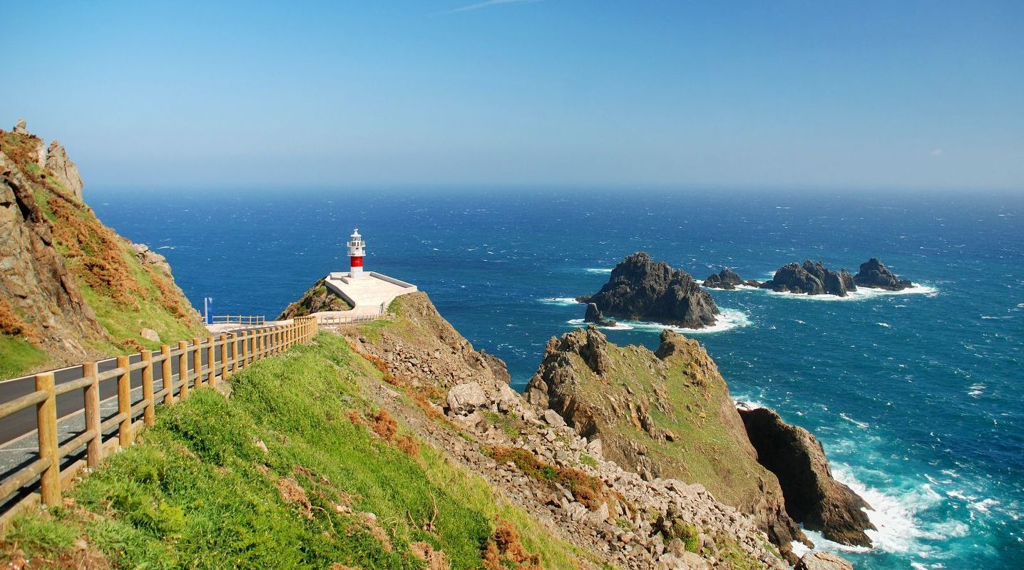
Ortegal pertenece a la Zona de Galicia Tras-Os-Montes, una de las zonas geológicas en que se divide el Macizo Ibérico. Algunos de sus materiales surgieron de la colisión de fragmentos continentales del Noratlántico y Báltico. Rocas básicas, ultrabásicas, gneis o eclogitas (piedras de gran dureza y muy resistentes a la erosión) abundan en el entorno del cabo. Pero es el granito negro la roca más espectacular de este paraje, ya que las que aquí encontramos, son las más antiguas de la península ibérica. En el resto del mundo aparecen rocas más antiguas, por ejemplo, en Rusia, Ucrania, Finlandia, Canadá, Australia o Groenlandia. Las rocas más antiguas conocidas están en Canadá y tienen en torno a 4000 millones de años.

Este granito negro se formó bajo la superficie terrestre, a partir de magma, hace aproximadamente 1160 millones de años, lo que a su vez, implica que esta área de la península ibérica es anterior a la llamada explosión de la biodiversidad en la Tierra. En aquella época la tierra tenía una apariencia "bastante inhóspita", sólo existían seres vivos unicelulares, la atmósfera era pobre en oxígeno y el sol era un 10 % menos brillante, según los investigadores.
Estas rocas permanecieron a gran profundidad hasta que afloraron cuando los continentes, que estaban agrupados en uno solo, Pangea, se dividieron, lo que produjo un acantilado de más de 600 metros de altura.
Geologia: Ecoglitas
La eclogita es una roca metamórfica máfica de grano grueso de composición basáltica que tiene un especial interés en geología por dos motivos:
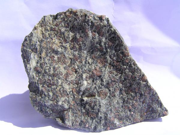
1) porque se forma a profundidades (presiones) mayor que las típicas de la corteza terrestre. Al formase sólo a profundidades de más de 35 km, la presencia de eclogita da información sobre procesos tectónicos que tienen lugar en el manto y la corteza inferior. La eclogita que alcanza la superficie de la Tierra es inestable y a menudo se produce metamorfismo retrogradante a anfibolita o granulita durante la exhumación
2) porque al ser una roca inusualmente densa, juega un papel importante en la isostasia y en facilitar la convección
Formación:
La eclogita resulta generalmente del metamorfismo de alta presión de roca ígnea (generalmente basalto o gabro) cuando ésta penetra en el manto terrestre en una zona de subducción o en una zona de colisión continental. También se pueden formar a partir de magma que cristaliza y enfría en el manto o en la parte inferior de la corteza. Las caracteristicas de eclogita están determinadas por la temperatura y presión requeridas para metamorfizar las rocas basálticas y llevarlas al ensamblaje eclogita. El típico ensamblaje de la eclogita es el granate con clinopiroxeno (omfacite). Las eclogitas registran presiones de más de 1,2 GPa (45 km de profundidad) a 400-1000 °C, a menudo a más de 600 °C. Es por tanto un metamorfismo de alta presión y temperatura media-alta
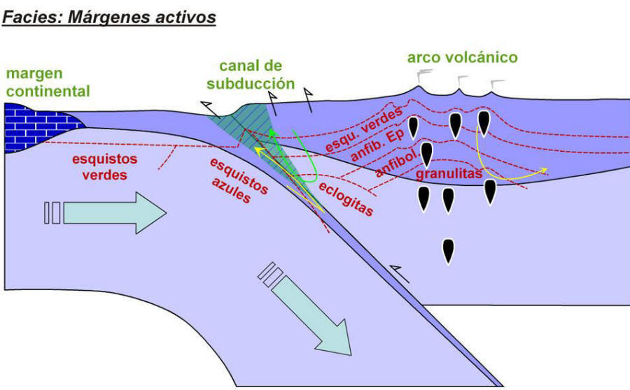
Las eclogitas que contienen lawsonita (un silicato hidratado de calcio-aluminio) están raramente expuestas en la superficie de la Tierra pues se forman a en zonas de subducción normal en la corteza oceánica a profundidades de ~ 45-300 km. Representan por tanto condiciones inusuales de exumación (erosión). La facies eclogita es la de mayor presión.
La peridotita es la roca más frecuente del manto superior y la que con más frecuencia sirve de roca fuente de los magmas. La fusión de la eclogita para producir magma es difícil de acuerdo con la petrología moderna. Serían necesarias proporciones poco razonables (cercanas al 100%) de fusión parcial para producir magmas basálticos, mientras que una peridotita requiere sólo una fusión del 1 al 25%.
Por tanto, el basalto se forma generalmente como fusión parcial de peridotita a 20-120 km de profundidad. La eclogita es más densa que la astenosfera circundante y suele haberse enfriado al llegar a una zona de subducción, por lo que es arrastrada a grandes profundidades sin fundirse. Si un flujo de convección mantélica devuelve esa eclogita, junto con peridotita, a la superficie, la primera se fundirá antes por decompresión. En esta circunstancias la eclogita puede convertirse en parte de los magmas producidos en plumas mantélicas.
Para logar este EarthCache, envíame un correo electrónico con la respuesta a las siguientes preguntas:
1) ¿Que tipo de roca es la Ecoglita? ¿En que zonas suele formarse?
2) En las coordenadas dadas, en la esquina Norte del mirador, mirando al otro lado del muro, a un metro del mismo, hay una roca de un metro aproximadamente. Describe brevemente su aspecto
3) En segundo punto, en el parking, en la pared. En esta pared de ecoglitas, podemos ver varios filones en la superficie. ¿Cual es su color? ¿Que espesor tienen aproximadamente?
4) Añade una fotografia tuya en el local, u otra en la que se pueda ver algún objeto, o tu nick en un papel.
-Si crees que as concluido con exito los objetivos de este Earth Cache, y me ha enviado todas las respuestas solicitadas, puede hacer el log. Luego yo comprobaré que son correctas, y si hay cualquier problema me pondre en contacto para arreglarlo.
-Logs sin respuestas enviadas previamente, seran borrados sin aviso
English
(Google translate)
Location
Cape Ortegal is a cape located on the Spanish Atlantic coast, within the municipality of Cariño, in the province of La Coruña, an autonomous community of Galicia. Cape Ortegal is the second northernmost point of the Iberian Peninsula, surpassed only by the Cape of the Stake of Bars. In addition, it is the most emblematic place of the municipality of Cariño, in La Coruña. Due to its extraordinary geological, morphological, ornithological and, of course, scenic value, Ortegal is included in the community interest site (L.I.C.) "Costa Artabra". It is part of the estuary of Ortigueira, one of the most important estuaries in northern Spain, as recognized by its multiple catalogations, which, among others, are: wetland included in the Ramsar agreement and therefore of international importance and area of special protection for birds, as well as a place of community importance
Ortegal belongs to the Galicia Zone Tras-Os-Montes, one of the geological zones in which the Iberian Massif is divided. Some of its materials arose from the collision of continental fragments of the North Atlantic and Baltic. Basic rocks, ultrabasic, gneiss or eclogite (stones of great hardness and very resistant to erosion) abound in the environment of the cape. But it is the black granite, the most spectacular rock of this place, since the ones we find here are the oldest in the Iberian Peninsula. In the rest of the world older rocks appear, for example, in Russia, Ukraine, Finland, Canada, Australia or Greenland. The oldest known rocks are in Canada and they are around 4 billion years old.
This black granite formed under the earth's surface, from magma, approximately 1160 million years ago, which in turn implies that this area of the Iberian Peninsula predates the so-called explosion of biodiversity on Earth. At that time the earth had a "rather inhospitable" appearance, there were only unicellular living beings, the atmosphere was poor in oxygen and the sun was 10% less bright, according to the researchers.
These rocks remained at great depth until they emerged when the continents, which were grouped into a single one, Pangea, were divided, which produced a cliff over 600 meters high
Geology
Eclogite is a coarse-grained mafic metamorphic rock of a basaltic composition that has a special interest in geology for two reasons:
1) because it forms at depths (pressures) greater than those typical of the earth's crust. When formed only at depths of more than 35 km, the presence of eclogite gives information on tectonic processes that take place in the mantle and the lower crust. The eclogite that reaches the surface of the Earth is unstable and often produces retrograde metamorphism to amphibolite or granulite during the exhumation
2) because being an unusually dense rock, it plays an important role in isostasy and in facilitating convection
Formation:
Eclogite generally results from high pressure metamorphism of igneous rock (usually basalt or gabbro) when it penetrates the Earth's mantle in a subduction zone or in a continental collision zone. They can also be formed from magma that crystallizes and cools in the mantle or in the lower part of the crust. The characteristics of eclogite are determined by the temperature and pressure required to metamorphize the basaltic rocks and bring them to the eclogite assembly. The typical assembly of eclogite is garnet with clinopyroxene (omfacite). Eclogites register pressures of more than 1.2 GPa (45 km depth) at 400-1000 ° C, often at more than 600 ° C. It is therefore a metamorphism of high pressure and medium-high temperature.
Eclogites containing lawsonite (a calcium-aluminum hydrated silicate) are rarely exposed on the surface of the Earth because they are formed in areas of normal subduction in the oceanic crust at depths of ~ 45-300 km. They therefore represent unusual conditions of exumption (erosion). The eclogite facies is the one with the highest pressure.
Peridotite is the most common rock in the upper mantle and is the rock that most often serves as the source rock for magmas. The fusion of eclogite to produce magma is difficult according to modern petrology. Unreasonable proportions (close to 100%) of partial fusion would be necessary to produce basaltic magmas, while a peridotite requires only a fusion of 1 to 25%.
Therefore, basalt is generally formed as a partial fusion of peridotite at 20-120 km depth. The eclogite is denser than the surrounding asthenosphere and usually has cooled down when it reaches a subduction zone, so it is dragged to great depths without melting. If a flow of mantle convection returns that eclogite, along with peridotite, to the surface, the first will melt before decompression. Under these circumstances the eclogite can become part of the magmas produced in mantle feathers.
To log this earthcache, send me an email with the answer to the following questions:
1) What kind of rock is the Ecoglita? In what areas it´s usually formed?
2) At the given coordinates, in the North corner of the viewpoint, looking at the other side of the wall, one meter away, there is a rock about one meter. Describe its appearance briefly
3) In the second point, in the parking, on the wall. In the "wall", we can see several dykes. What is their color? How thick are they?
4) Add a picture of yourself at the place, or another one where you can see an object, or your nickname on paper.
-If you believe you have successfully completed this Earth Cache goals and has already sent to me all the requirements as requested, Please, feel free to log it as found. Later i will verify the requirements sent and, if necessary, contact you in order to make the necessary corrections to your log.
-Logs without answers, will be deleted without notice.