The Halawa Valley Earthcache - A Story of Sapping
Welcome to the scenic moku of Halawa. The most visible feature of this part of Molokai is the impressive Halawa valley. The visage dominates the area and is easily recognizable from GZ. As you look West you should be able to see the 1.75 mile long valley and the meandering Halawa and Papalaua streams. Halawa valley is unique in many regards, but it is perhaps most famous among geologists for being a "Sapping Valley" or one that is predominantly formed by groundwater drainage. Halawa valley has been studied by Geologists for decades, and most recently its geological processes have been used to model possible erosion patterns on Mars! As with all earthcaches there is no log to sign, rather you must make observations at the site in order to answer the questions at the bottom of this cache page. Please send all your answers to me via the messaging system prior to logging your finds. I hope you enjoy the spectacular views this valley has to offer, and learn something new at the same time!
What do you See?
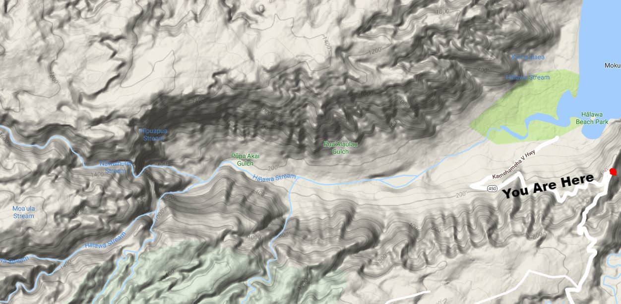
Start by facing north. As you look down below on the impressive vista before you, you'll see the end of the road, and therein lies the Halawa Valley State Park. This area is the head of the valley. The two pocket beaches here mark where the Halawa stream empties into the Pacific Ocean. As you gaze up the valley you'll see two sets of waterfalls. These are the Moa'ula and Hipuapua Falls and they connect the swampy marshlands of the upper plateaus with the meandering streams below. To the East you'll find steep cliffs leading down to the water's edge. While not as famous as the sea-cliffs on the northern part of the island, they paint an imposing picture. To give you a better illustration of what's in front of you, below you'll find a topographical map of the Halawa Valley area.
What Is a Valley?
While this might seem like a fairly basic question, it's important to ensure we have mastered the basics before proceeding onto more difficult concepts. Valleys are one of the most common land-forms on the surface of the planet. They are carved by flowing water or flowing ice through the process of erosion, which is the gradual wearing away of Earth surfaces through the action of wind and water. Valleys take on a wide variety of forms—from steep-sided canyons, such as the Grand Canyon on the Colorado River, to broad plains, such as the lower Mississippi River valley. The form of a valley depends on many factors, including what is eroding it, the slope of the land surface, the nature of the soil or rock where the valley is being created, and time.
To put it simply, a valley is a relatively large hollow or depression bounded by hills or mountains on Earth's surface that is developed by stream erosion or glacial activity and that is drained externally.
So How Many Types of Valleys are There?
This is an interesting and valid question. When most people look at a valley they only see some land between two higher areas; but geologists actually have many ways of classifying valleys.
- V - Shaped Valleys: V shaped valleys are valleys formed by rivers, they have a V-shaped
 cross-section and very steep sides. These valleys are usually found near the source of a river due to the presence of a steeper bank, however, they can also be formed downstream.
V-shaped valleys are formed by erosion. The river carries stones and rocks in its water. The force of the water and the grinding of rocks and stones cut down into the river bed to carve out a valley. Over time the valley becomes deeper and wider.
- U - Shaped Valleys: A U-shaped valley is the shape left after a valley has been deepened and widened by an erosion process. This may be a result of a glacier, flooding, or groundwater erosion. The original V-shaped valley, which would have been made by a river, is widened and deepened.
- Flat Floored Valleys: The third type of valley is called a flat-floored valley and is the most common type in the world. These valleys, like V-shaped valleys, are formed by streams, but they are usually older, or more developed. As the slope of a stream's channel becomes smooth, and begins to smooth the steep V or U-shaped valley, the valley floor gets wider. Over time, the stream continues to erode the valley's soil, widening it further. During this process, the shape of the valley changes from a V or U shaped valley into one with a broad flat valley floor. An example of a flat-floored valley is the Nile River Valley.
- Rift Valleys: A rift valley forms where the Earth’s crust is spreading or splitting apart. This kind of valley is often narrow, with steep sides and a flat floor. Many rift valleys have been found underwater, along the large ridges that run throughout the ocean. These ocean ridges are formed as tectonic plates move away from one another.

Even within these categories there are many other ways to classify valleys. However these will serve as a basis for understanding what exactly geologists look for when determining how to classify a valley.
Groundwater Sapping - A Different Type of Erosion
Groundwater sapping is a geomorphic erosion process that results in the headward migration of channels in response to near constant fluid discharge at a fixed point. The consistent flow of water displaces fine sediments which physically and chemically weathers rocks. Valleys that appear to have been created by groundwater sapping occur throughout the world in areas such as England, Colorado, Hawai’i, New Zealand, and many other places.
However, it is difficult to characterize a landform as being formed exclusively by groundwater  sapping due to phenomena such as pluvial runoff, plunge-pool undercutting, changes in water table level, and inconsistent groundwater flow. An example of drainage ways created purely by the outflow of subsurface fluids can be seen on the foreshores of beaches. As the surge of water and sand brought to land by a wave retreats seaward, the film of water becomes thinner until it forms rhomboid shaped patterns in the sand. Small fans form at the apex of the rhombic features, which are eventually fed by the remaining back-flow of water traveling down-slope. Channels begin to form head-ward in the form of millimeter wide rills along the sides of the fans; the creation of these small channel networks culminates when the last of the backwash dissipates.
Erosion by sapping tends to produce steep-sided U-shaped valleys of fairly uniform width with box-like, "theater-shaped" headwalls. They are characterized by low drainage density, one main channel and a lack of small inlets and short stubby tributaries.This contrasts with the more common branching or dendritic pattern of V-shaped valleys produced by overland flows that become wider with distance from their source. Groundwater sapping has been suggested as the cause for erosion of the valley and channel networks on Mars, although studies show that groundwater alone can not excavate and transport the material required to create these canyons.
To put this in simple terms, in a valley shaped by sapping, the level of the groundwater affects the movement of the primary stream in such a manner to form the valley. This is particuarly evident in valleys where the higher plateau areas are swampy/boggy as they drain through the bedrock to the aquifer below.
Logging your Earthcache
Hopefully all the geologic terms didn't confuse you too much. In order to log this earthcache as a find, you need to answer the following questions and send them to me via the message center. You do not need to wait for a response from me to log your find.
- What do you estimate the width of the Halawa Valley is? For a size comparison, the length of the valley is given in the reading above. What type of valley does that make Halawa?
- Is this width constant or dynamic as you proceed from the headwall of the valley to the originating source at the waterfalls?
- Using your previous answer and your own observations at GZ, is there evidence to support that this valley created by groundwater sapping? Why or why not?
- (Optional) Post a photo of yourself at GZ!
Sources
This earthcache has only provided a most basic overview of the erosion process known as "groundwater sapping." If you wish to learn more I highly recommend you consult some of the resources listed below.
- http://www.soest.hawaii.edu/coasts/publications/hawaiiCoastline/molokai.html
- http://www.scienceclarified.com/landforms/Ocean-Basins-to-Volcanoes/Valley.html
- https://www.nps.gov/kala/learn/management/upload/MinkV.pdf
- "Spring Sapping and Valley Network Development" by Baker, Kochel, Laity and Howard (1990)
- "Morphology of Large Valleys on Hawaii: Evidence for groundwater sapping and comparisons with Maritan valleys" by Kochel and Piper (1986)
- Barta G., De Hon R., Hargitai H. (2014) Sapping Valley. In: Encyclopedia of Planetary Landforms. Springer, New York, NY
- https://mountainsandvalleys.weebly.com/valleys-information.html
- https://en.wikipedia.org/wiki/Groundwater_sapping