Background
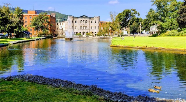
The Borough of Roaring Spring was so-named for its "world famous" natural spring, which is a unique geological feature located in the historic heart of this small town. Once known as the Big Spring, it puts forth roughly eight million gallons of water per day, the sound of which could be heard "roaring" from miles away. This "roar" is long gone, as much of the water is now diverted for other uses, but the spring remains. It has been, and still is, the foundation of many local businesses, including farms, a gristmill, paper mill, fire company, and water company, among others. Several of these businesses are visible from the posted coordinates. The area is now a popular local public park and is also used as a venue for various events, while still remaining an important component of the local infrastructure.
Springs & Magnitude
A spring represents a point where an underground source of water, known as an aquifer, breaks through the Earth’s surface. These may be found in caves, on mountainsides, in volcanic areas, and anywhere else where the porous nature of the local geology allows this water to escape its subterranean prison, as it follows the path of least resistance toward the surface. Depending on local conditions, this water may vary in color, temperature, taste, and composition.
In the case of this specific spring, you will notice the water here coming from what appears to be a hillside, with no apparent external source or input. Fissures in the permeable limestone bedrock, which is common in this area, have been slowly created over millions of years by erosion and dissolution from the water. These cracks provide an outlet from which the water flows forth. The hilly terrain of our "Ridge & Valley" Appalachian region offers many opportunities for these underground water sources to emerge and disappear again. A spring house has been constructed around the area to control the flow of the water. The central fountain helps to circulate the water before it drops over a spillway at the other end of the dam and disappears again. Springs can be classified in several ways, including their source, properties of the water, and the magnitude of flow.
Logging requirements
To complete this EarthCache, you will need to bring along a container of known volume to hold water (a one-gallon jug works best) to take a measurement, then email or message your observations to me before logging your find online. Please do not post your answers in your log, but feel free to tell us about your experience. As EarthCaches are designed to be educational, I reserve the right to delete any logs for which I have not received the appropriate response for the questions listed below. If you are making the find as a group, only one email or message is necessary, just please be sure to include the caching names of all those present.
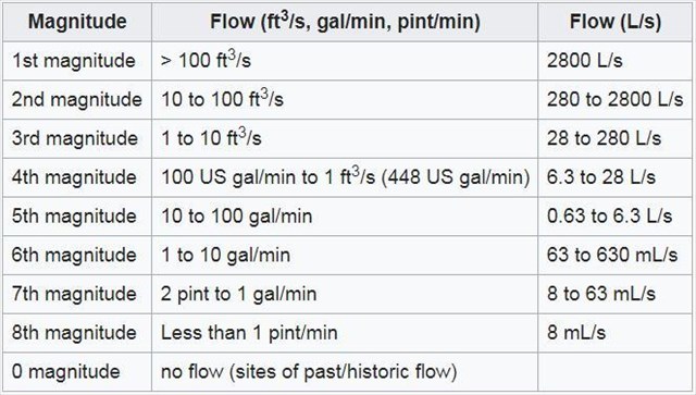
- Using the magnitude chart above, and based on information included in the description, please email me the classification of this spring. (Note – This will be different than your answer to #2, which only measures the water from the pipe, not the discharge of the entire spring.)
- Using your container, measure the flow rate of the water (in gallons per minute) coming out of the small pipe located at the additional waypoint. What is its magnitude? How does that compare to the entire spring?
- Observe the water you collect - do you see any colors from dissolved minerals? Bubbles from carbon dioxide? How does it smell? What about the taste?
- What factors, either natural or man-made, do you think could influence this flow rate of the spring? Consider local environment, climate, activities, and/or geologic erosion or actions in your answer. (Use your own knowledge or research.)
*Optional: Please upload a photo you took during your visit. The photo can be of anything you like - cacher, GPSr, the spring, the park - the more creative, the better! Can you show us your best fountain pose? 
*Notes
- Free parking is available right next to the spring, as well as on nearby streets, in the rare event that the lot is full.
- Please do not feed the ducks, fish, or geese. I know you probably want to, but just...don't.
- I repeat, DO NOT FEED THEM. While this used to be permitted, it is now prohibited by Borough ordinance.
- There is no swimming or wading allowed in the spring.
- Anyone is welcome to fill jugs of water for free from the pipe and you’ll likely encounter others doing the same, so you may need to be patient and wait.
- The path to the pipe is wheelchair-accessible, though the actual pipe may not be. During winter, this could be more difficult.
- Please take a few moments to CITO and enjoy your visit to this beautiful park.
- For an added treat, visit during evening hours (after dark) to see the fountain lit up with vibrant colors!
Resources
~* Congratulations to KB3PPR & KB3PPS for the FTF! *~