I love bridges! I've always been interested in them. Maybe it started back when I was seven years old and heard about the moving of the London Bridge to Arizona, piece by piece...how cool is that! Or my fascination whenever I go over a really high bridge and see the great view from it. Or seeing some new innovation in bridge design or a good-looking bridge, be it in the daylight or at night. If you haven't already done so, please read through "THE SERIES EXPLAINED" section below and then work on this fun, informative, and easy puzzle.
HELPFUL HINT: When looking at the links, click right mouse button and open up links in either another tab or window. This way you'll still have the main cache page to view.
THE PUZZLE
This is ninth in a series of caches about bridges. This time it's about water bridges, which include navigable aqueducts (water bridges that have navigable canals over other waterways, land, railways, etc.), standard aqueducts, a tunnel, and a bit of history.
The final coordinates for this puzzle are determined by finding the following answers.
Coordinates are: N43 AB.CDE W77 FG.HIJ.
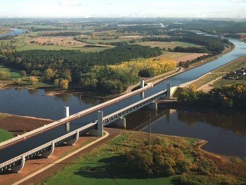
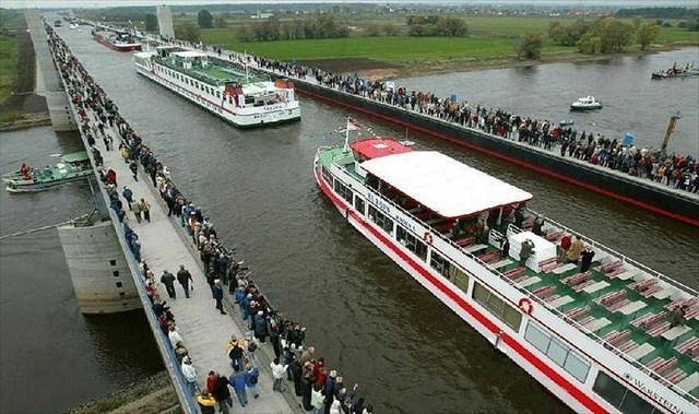
A: Magdeburg Water Bridge
Magdeburg, Germany
The Magdeburg Water Bridge is the longest navigable aqueduct in the world. It connects the Mittelland Canal to the Elbe-Havel Canal. Work on the Mittelland Canal portion began in 1905 and continued until 1942 when World War II halted it. It resumed in the late 1990s and opening in 2003. The water in it is only 13.9 feet deep.
A is the second digit in the total length, in feet.
https://en.wikipedia.org/wiki/Magdeburg_Water_Bridge
BONUS VIDEO: Nice views of the water bridge.
https://www.youtube.com/watch?v=4k1a7Q2XBlI
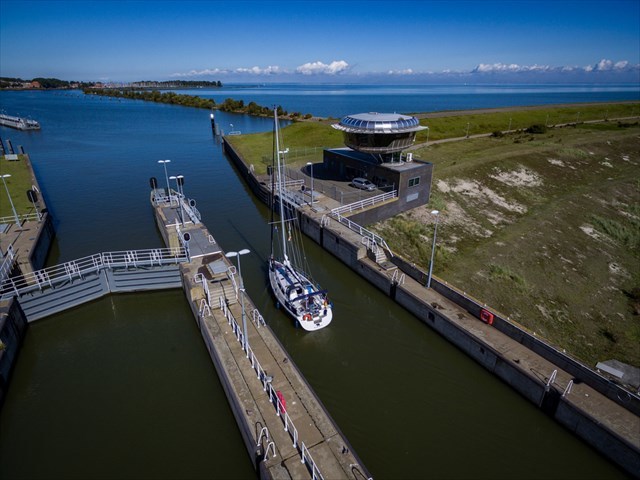
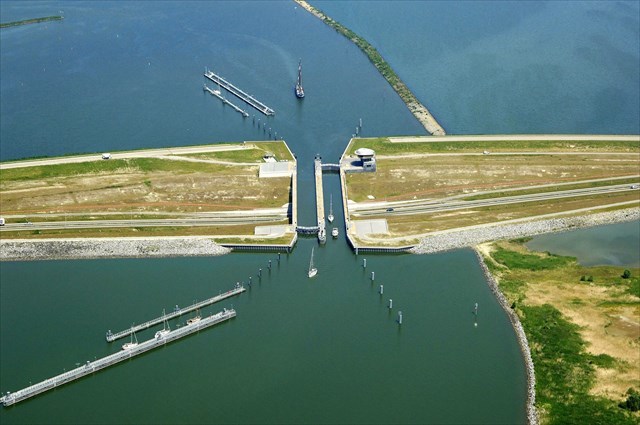
B: Krabbersgat Naviduct
Flevoland province, Netherlands
A naviduct is a navigable aqueduct in which the waterway also includes a lock. Krabbersgat Naviduct was the world's first, opening in April 2003. Without the lock the water flow through the aqueduct would be too high for navigation.
B is the second (or third) digit in the year the works (which include the naviduct) were commissioned.
https://en.wikipedia.org/wiki/Naviduct
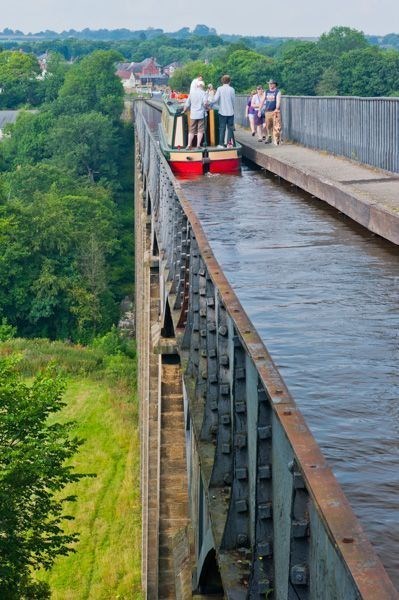
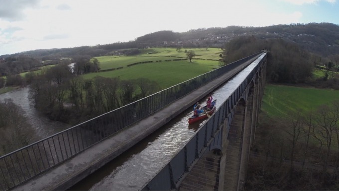
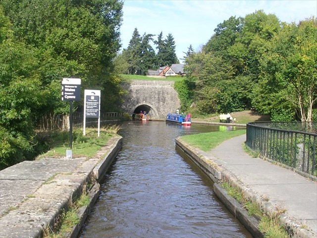
C: Pontcysyllte Aqueduct
Vale of Llangollen, Wales
The Pontcysyllte Aqueduct is the longest aqueduct in Great Britain and the highest canal aqueduct in the world at 126 feet high! It consists of 18 arches and is made of stone and cast iron. It is used for narrowboats, which are boats specifically designed to fit the narrow waterways of the United Kingdom.
C is the second digit in the height of the bridge, in feet.
https://en.wikipedia.org/wiki/Pontcysyllte_Aqueduct
BONUS VIDEO #1: Short video that highlights the aqueduct's height.
https://vimeo.com/246830381
BONUS VIDEO #2: If the last two photos make you cringe a little, watch this video of a kayaker as he goes over that bridge.
https://www.youtube.com/watch?v=1_8Ue4J1NW8
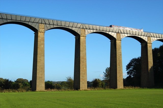
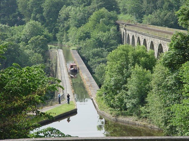
D: Chirk Aqueduct & Tunnel
Chirk, England-Wales border
The Chirk Aqueduct includes the Chirk Tunnel. The tunnel is on the Llangollen Canal, which is a name you may recall from Bridges #2: Lift Bridges (specifically, the hand-cranked lift bridge). The tunnel is wide enough for a single standard narrowboat and it's straight enough that a captain can see if another boat is in the tunnel. The tunnel has a complete towpath inside, which can be used for walking through it.
D is the last digit in the length of the tunnel, in meters.
https://en.wikipedia.org/wiki/Chirk_Tunnel
BONUS VIDEO: Short and amusing time lapse of a ride through the tunnel. Watch out for all those boats at the other end!
https://www.youtube.com/watch?v=deUHA4ywg5g
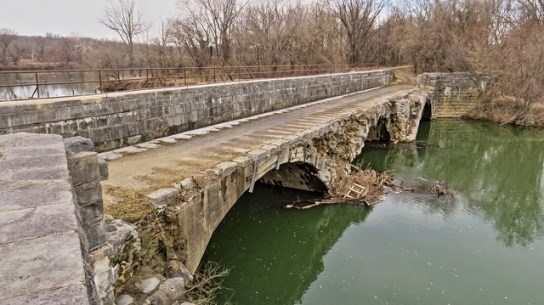
E: Conococheague Creek Aqueduct
Williamsport, MD, USA
The Conococheague Creek Aqueduct is another navigable aqueduct. The interesting thing about this one is a bit of its history. Here's an excerpt from one online link: " The wall of the aqueduct collapsed in the early morning of April 29, 1920 as a boat was passing though. The captain reported that he saw the wall “waver” as it entered the aqueduct and upon realizing the imminent danger he was in, he jumped from his boat to the abutment. The mule drivers upstream noticed the commotion and immediately released the 4 mules, saving them from being pulled into the aqueduct and swept into the river. The boat quickly washed out of the aqueduct and into the river with the escaping canal water."
E is the second digit in the number of feet between its north and south abutments.
https://www.nps.gov/choh/conococheague-aqueduct.htm
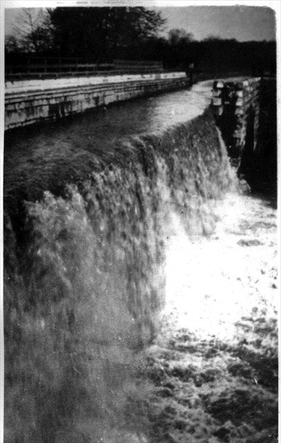
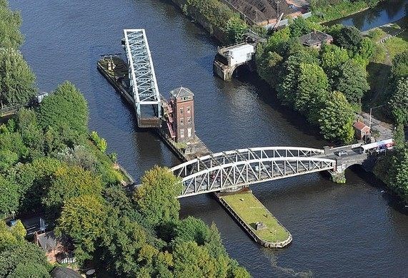
F: Barton Swing Aqueduct
Barton upon Irwell, Greater Manchester, England
The Barton Swing Aqueduct is the first and only swing aqueduct in the world. This structure came about because of a need in the 1890s to accommodate taller boats that needed to pass through. It opened to commercial traffic in 1894 and remains in regular use. The aqueduct itself can be used by narrowboats and broad-beam barges.
F is the first (or second) digit in the length, in feet, of the iron trough that essentially is the swing aqueduct.
https://en.wikipedia.org/wiki/Barton_Swing_Aqueduct
BONUS VIDEO: Interesting video about its history, construction, and operational details.
https://www.youtube.com/watch?v=IXOlJkPy9SA
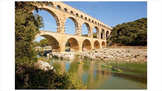
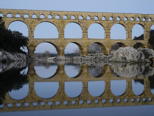
G: Pont du Gard Aqueduct
Vers-Pont-du-Gard, France
So far, all of the aqueducts and their bridges have been navigable ones. This bridge is part of the Pont du Gard Aqueduct, which brought water to the city of Nîmes, France up until the 6th century. It's estimated that it supplied about 8,800,000 imperial gallons of water a day. It was built as a three-tier aqueduct bridge and is the highest of all the elevated Roman aqueducts.
G is the number of spans in the low part of the aqueduct.
https://en.wikipedia.org/wiki/Pont_du_Gard
BONUS VIDEO: Some history and details about the aqueduct.
https://www.youtube.com/watch?v=zQqtiwIq9gw
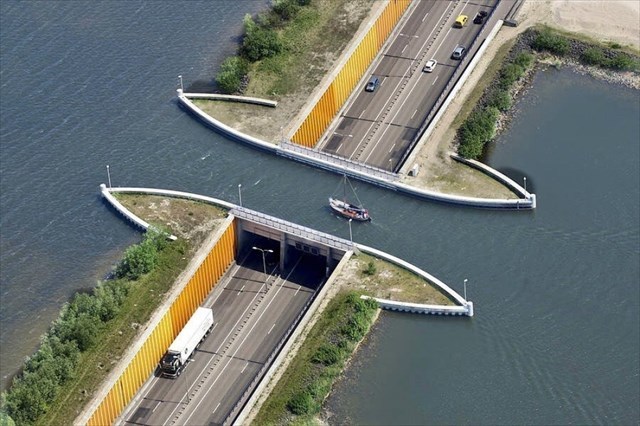
H: Veluvemeer Aqueduct
Harderwijk, Netherlands
The Veluvemeer Aqueduct is an aqueduct that goes over a roadway. It is 3 meters deep (9.84 feet) to allow small boats to pass through. There's a walkway as well so folks can enjoy the view. It opened in 2002.
H is the last digit in the length of the aqueduct, in meters.
https://www.amusingplanet.com/2014/03/aqueduct-veluwemeer-in-netherlands.html
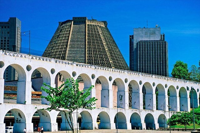
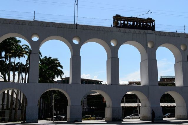
I: Carioca Aqueduct
Rio de Janeiro, Brazil
The Carioca Aqueduct's bridge is a great example of re-use. What once was an aqueduct that carried water to Rio de Janeiro is now home to a tramway. The aqueduct was deactivated at the end of the 19th century. It was later adapted to be the viaduct for the Santa Teresa Tramway.
I is the third digit in the year that the structure was adapted.
https://en.wikipedia.org/wiki/Carioca_Aqueduct
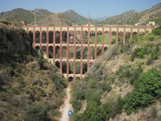
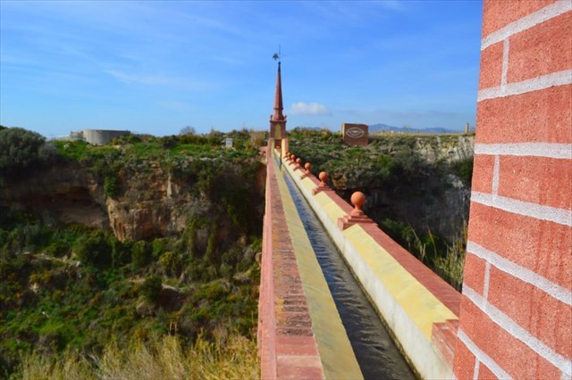
J: Eagle Aqueduct
Nerja, Andalusia, Spain
The Eagle Aqueduct (aka Nerja Aqueduct) is another example of a non-navigable aqueduct. It consists of four level. Originally built in the 19th century, it brought water to the San Joaquin Sugar Mill, and it continues to be used for local irrigation. The bridge in the photos show the restored version; restoration was done in 2009-2011.
J is the first digit in the number of arches.
https://andaluciarustica.com/en/nerja-the-eagle-aqueduct.htm
Check your answers on Certitude, where you will also get useful and informative details about the final location.

You can validate your puzzle solution with certitude.
THE SERIES EXPLAINED
To share my interest in bridges I've created this series of 12 caches. For each cache you'll look up information for 10 bridges. The bridges are from around the world, and no bridges are repeated throughout the series. So 12 caches with 10 bridges...120 bridges for you to enjoy!
The caches will be released throughout the winter months, allowing you to spend some time sitting nice and cozy in your pajamas & bunny slippers, researching the answers and watching videos or viewing photographs about each bridge. And I even give you links to where you can find the answers! Once you've solved it though you'll need to take off the bunny slippers, bundle up and go find the cache.
I've tried to make the hides as winter accessible as possible for the location. Happy caching!