For younger geocachers: Ponderosa Pines: Giants of the Colorado Forest
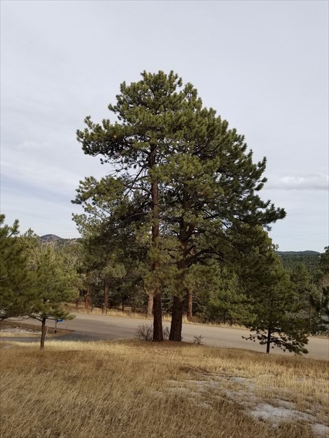
The tall trees around you are ponderosa pines, one of the most common and important trees in Colorado. They like sunny, dry places and often grow spaced far apart, creating open forests where grasses and animals can live underneath. These trees can live for hundreds of years and are tough enough to survive fires, heat, and strong winds.
Ponderosa pines are easy to recognize. On warm days, their thick reddish bark smells like vanilla or butterscotch! Their long needles grow in bundles of three, and they have rounded tops. Many animals depend on these trees for food and shelter, including deer, squirrels, and birds. As you search for the cache, take a moment to smell the bark and look up—you’re walking among some of Colorado’s true forest giants!
The ponderosa pine (Pinus ponderosa) is the most widely distributed pine tree in North America, and occupies a vast area in the West. Ponderosa pine forests, woodlands, and savannas occupy approximately 2 million acres in Colorado, or 8 percent of the state’s forested land. They are common in the four corners states, as well as AZ and WY, with some presence in Idaho, Texas, South Dakota, and the west coast states.
Ponderosa pine is well adapted to high temperatures and low moisture conditions. Although it is most common between 6,000 and 9,000 feet, it appears around 5,000 feet at the transition of prairies and shrublands into open savannas with widely spaced trees. As the elevation increases, these trees become more numerous, but the mature trees are spaced well apart, which is their natural setting in the ponderosa pine woodland. These mature trees are not very shade-tolerant, and may live to several hundred years old if they are allowed to absorb the solar energy on all sides. Between the large trees are smaller, younger versions of this species, as well as an understory of native grasses, berry-bearing shrubs, with occasional Douglas firs, Colorado blue spruce, and aspen trees mixed in based on terrain slope and water availability. On steeper terrain and at the higher elevations of their range, they are part of a dense, mixed forest with little sunlight reaching the ground. This environment is considered more of a forest than the woodland appears to be.
The ponderosa pine evolved in the more open environment of the woodland, where the mature trees encountered frequent fires (usually caused by lightning), but they have quite thick and spongy bark, which protects the trees from grass fires in their area, which the smaller trees cannot survive. The advent of aggressive fire suppression in the past century resulted in increasing encroachment of Douglas fir trees into Ponderosa forests, and they are more likely to transfer a fire from the ground into the tree crown, with devastating results on the mature ponderosas. The trees are also subject to damage from dwarf mistletoe and pine beetles. Native americans are reported to have eaten the inner bark, chewed the sap like gum, and made a blue dye from the roots.
These trees were more accessible to logging than other species, and with the development of mining and railroads in Colorado in the mid-1800s, many trees were cut for lumber as the non-native americans flowed into the state to seek their fortunes. These trees play a significant role in the recreation and water supply needs of current residents and visitors, and are found in the majority of the state’s wildland-urban interface communities. They also create a rich environment for wildlife such as mule deer, foxes, bears, mountain lions, and more recently coyotes, along with a variety of smaller mammals and birds that eat the seeds. Porcupines eat the inner bark, deer eat the twigs and needles, and the Abert’s squirrels are completely dependent on this tree for their survival.
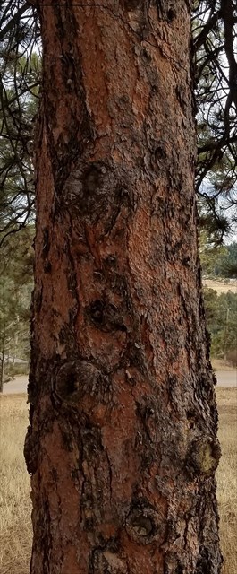
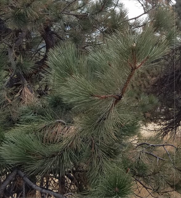
The ponderosa pine is relatively to recognize in Colorado, with its rounded top, its reddish bark that smells like butterscotch or vanilla on warm days, its gray-green needles that are about 4 or 5 inches long, and fused together into packets of 3 or sometimes 2 where they attach to the branch. they can be up to about 3 feet in diameter at eye level, about 150 feet tall, and may live for several hundred years. they have a long taproot that allows them to access deep water supplies in the coarse soil of the state, and helps them survive strong wind storms.
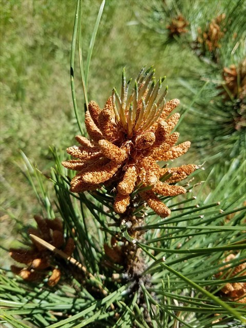
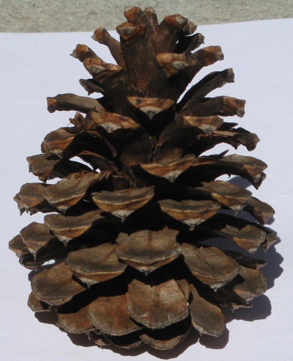
All pine trees are wind pollinated, and each ponderosa produces both male and female cones. the 1"-long male cones (left photo above) are small and form near the branch ends in june, and they turn yellow with the pollen produced, which is released in dense clouds, and covers cars and driveways. the 4”-long female cones (right photo above) absorb the pollen from adjacent trees, and are fertilized for the production of seeds between the scales of the female cones, which can produce new trees when released and deposited on the soil beneath the trees. the trees also shed about 1/3 of their needles every year, and the ground near the trees is often covered with inches of these needles. the lower branches of these trees will dry up over time, and can be self-pruned by grass fires and animal herd passage. the lower elevations of staunton state park are dominated by ponderosa pine woodlands, and they are higher elevation mixed forests which contain significant numbers of these trees.
 This cache is located within Staunton State Park, which has one public entrance along S. Elk Creek Road, six miles west of Conifer, about 1.5 miles off U.S. Highway 285. Parking along either side of S. Elk Creek Road and Upper Ranch Road adjacent to the park boundary is prohibited. All vehicles entering the park must have a daily park pass ($10) or a CO state park annual or special pass.
The Park is open year-round, and day use hours at 6:00 am to 10:00 pm. A walk-in campground (up to ¼ mile from parking) is open for public use, and overnight parking is currently permitted only for those staying in the campground. During summer and autumn weekends, the park may reach capacity, and cars are allowed to enter only if a parking space is available. Horse trailers are admitted if space is available for parking trailers in the new, dedicated, unpaved parking lot. All Park trails are natural surface, some trails are hiker-only, but other trails are multiuse for bicycles and horses also. Information about the park can be found on Staunton State Park website
All visitors must follow park rules and regulations. These include dogs on leash at all times, clean up after pets, travel on developed trails to the extent feasible, leave no trace, respect areas closed for resource management, and be careful around wildlife (especially mountain lions, coyotes, and black bears). Fires are strictly prohibited, except for camp stoves with an on/off switch in the designated campsites and grilles found in the picnic areas. No motorized vehicles are allowed on trails within the Park. An exception is the special tracked chairs that the Park offers to visitors who cannot access selected trails on their own mobility. Pack your own trash out of the back country, and trash receptacles are located near the parking areas. Also, be prepared for changing weather, bring adequate water and footwear, and trails may be snow-covered or icy in winter.