An Eternal Debt of Gratitude is owed to BarnyardDawg for doing so much work on these Earthcaches to help get them published! These caches will always tie the South Dakota and Malaysia Geocaching communities together!
The Big Sioux river, with its tributaries, drains the major portion of the area qovered by the quartzite in South Dakota. The exposed quartzite strata at Falls Park are classified as Sioux Quartzite, dating back 2280 ± 110 Ma (2.28 billion years to about 110 million years ago).
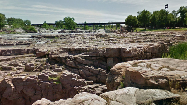
Sioux Quartzite is extremely resistant to erosion, but certainly not immune to it. Erosion has revealed several interesting geological features. Among them, beach phenomena and cross-bedding.

Cross-bedding at Falls Park, Sioux Falls.
Beach phenomena are not uncommon in the quartzite, being" expressed "in ripple marks and false or cross-bedding. Cross-bedding is layering within a stratum and at an angle to the main bedding plane.
One of the best examples of cross-bedding observed in South Dakota can be found here at Falls Park. Here the normal stratum are nearly horizontal or inclined slightly toward the south, with overlying false beds tilted in a significant angle to the north. Cross-bedding can be observed when you look in the direction of the railroad bridge. The exposed top stratum can largely be identified as petrified beach. Looking down at the bottom tier of the waterfall, a vertical rockface provides and example of normal strata, sitting almost level and layered parralel to each other. Behind you, on the other side of the fence, ripples from the petrified beach can be observed in various states of weathering.
These ripples serve as a paleocurrent indicator, a geological feature (typically a sedimentary structure) that helps one determine the direction of flowing water in the geologic past. An invaluable tool in the reconstruction of ancient depositional environments. There are two main types of paleocurrent indicators; Unidirectional, which give a clear, single direction of flow, and bidirectional, which give a good linear direction, but it is unclear which direction along the linear trend the water flowed.
How to claim this EarthCache?
Once you know how to identify the ripples and cross-bedding layers, continue to observe your surroundings during your visit at Falls Park to get an idea of the extend of these features.
Email me the following;
1. The text "Big Sioux River Beach" on the first line.
2. The answers to the following questions;
- When you observe rock surfaces around the park you can clearly identify the beach ripple effect in various states of weathering. Are these ripples limited to a specific location, or are they a common sight here at the falls with clearly identifyable examples on either side of the river?
- Describe the surface of the false bedding containing the ripples, how does it feel and why?
- In wich general direction did the paleocurrent flow? Was it unidirectional?
- Given that the normal strata at Sioux Falls are nearly horizontal, at what angle would the overlying false beds be tilted to the north? An approximate answer in degrees will suffice.
- Save the active river bed riddled with debris, would you agree that most of the visible rock at Falls Park's river banks could be classified as false bedding (pertrified beach)? Explain your answer.
3. Optional task: Share your experiences and photos taken during your visit.