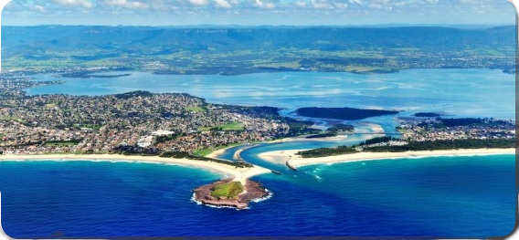
Lake Illawarra
Lake Illawarra can be accessed from a number of points around the shoreline.
Lake Illawarra is a trained intermediate wave dominated barrier estuary or coastal lagoon. Lake Illawarra receives runoff from the Illawarra Escarpment through Macquarie Rivulet and Mullet Creek drawing from a catchment area of 238 square kilometres. Incidentally, Lake Illawarra has more than five freshwater inlets. Covering a surface area of 35.8 square kilometres this relatively shallow lake has an average depth of 2.1 metres due to the infilling of sand that has been eroded from the surrounding catchments.
Located on the south-eastern side of the lake, at Windang, is a narrow tidal entrance to the Tasman Sea.
A lagoon is a common coastal feature around the world. Lagoons are often called estuaries, bays, sounds or lakes. Most, if not all lagoons do not include the term ‘lagoon’ in their name; Lake Illawarra is an example.
The terms "lagoon" and "estuary" are often loosely applied.
LAGOON
Normally elongated and parallel to the coast
Have little or no fresh water inflow and little or no tidal flow
Is shallow and separated from a larger body of water by shallow or exposed barrier islands or reefs.
ESTUARY
Usually drowned river valleys, elongated and perpendicular to the coast
Receives a regular flow of fresh water.
WHAT IS A LAGOON
There are two types of Lagoons; an Atoll and a Coastal Lagoon.
An Atoll is a ring-shaped coral reef, island, or series of islets. An atoll surrounds a body of water called a lagoon.
Coastal Lagoons form in areas with small tidal ranges along coastal plains with flat or gently sloping landscapes where barrier islands or reefs can develop, when the sea-level is rising relative to the land along the shore (either because of an intrinsic rise in sea-level, or subsidence of the land along the coast). When a shallow basin near the coast gradually erodes, and the ocean seeps in between the sandbars or barrier islands a lagoon is created.
Due to the gentle slope of the coast, coastal lagoons are shallow and sensitive to changes in sea level of which determines the size and depth of coastal lagoons. When the sea level is low, coastal lagoons are swampy wetlands. When the sea level is high, they can look like coastal lakes or bays, and may let the sea breach or destroy barrier islands leaving reefs too deep under water to protect the lagoon.
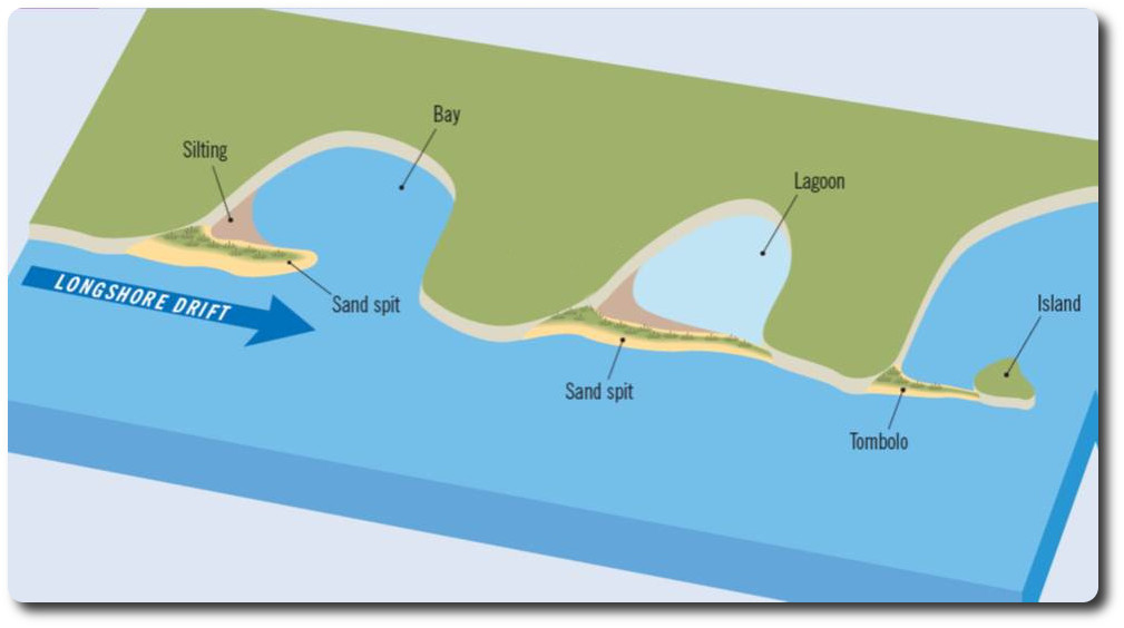
Coastal lagoons are usually connected to the open ocean by inlets between barrier islands. These inlets affect the nature of the lagoon according to their size and number as well as inflow of fresh water, precipitation and evaporation. Those with many wide inlets have strong tidal currents and mixing.
Coastal lagoons tend to accumulate sediment from mangroves, in-flowing rivers, runoff from the shores, and by tides carrying sediment through the inlets. Even storm waves can over-wash barrier islands depositing large quantities of sediment in a lagoon. Lagoons behind coastal barriers are normally zones of fine sedimentation due to the quieter conditions. The fine sediment transported by rivers from inland areas.
Lagoons with little or no inflow of fresh water, little or no interchange with the ocean, and high evaporation rates may become highly saline. While those with no connection to the open ocean and a significant inflow of fresh water may be entirely fresh.
Intermediate wave dominated coastal waterways are when waves are the principal factor in shaping the overall geomorphology. Characterised by a sandy barrier and a narrow entrance that is backed a broad central basin and a fluvial delta, where the river enters the basin. (A Fluvial Delta is sedimentation build-up at the point where a freshwater source enters an estuary)
Narrow entrances can close for periods of time hence the need for the construction of rock walls to increase wave energy within the waterway, due to the reflection of waves from the shoreline.
A wave-dominated estuary represents a coastal bedrock bay that has been partially infilled by sediment from the catchment and the ocean, in which waves are the dominant force shaping the physical features of the earth’s surface.
In Australia, wave-dominated estuaries are most abundant on the south-east and south-west coasts, where they occur on exposed coastlines with a relatively small tidal influence. Wave-dominated estuaries feature a barrier at the mouth that encloses a central basin, and the barrier creates a narrow entrance of water between the central basin and the sea. Sediment in wave-dominated estuaries ranges from fine to coarse sands in the barrier and tidal inlet deposits, fine organic muds and sandy muds in the central basin, to coarse, unsorted gravels, sands and muds (mostly from the land) in the river-mouth. Depending on the amount of incoming sediment, the central basin may be irregularly-shaped by following the shape of the flooded bedrock valley.
Fine and coarse sediment enters the estuary from the catchment with differing amounts depending on catchment and climatic conditions, and the volume of freshwater input. The amount of sediment from the erosion of rocks is supplied by rivers to the entrance of the estuary is usually relatively large. Coarse sediment (i.e., gravels and sands) is deposited at the head of the estuary forming a fluvial bayhead delta that, unless disturbed by waves, progrades into the central basin. Fine sediment (i.e., muds, clays, and organic material) is deposited on the fringes of the central basin by river processes, tides, and internally generated waves. The waving effect (movement) of saltmarshes and mangroves also aid in depositing the sediment, as do floods. Coarse ocean sediment is driven along the coast by strong waves and deposited as barrier, and tidal deltas at the entrance. During storms, large waves transport sediment over the barrier and form washovers that extend into the central basin.
The sediment trapping efficiency of wave-dominated estuaries is very high because sediment from the catchment and marine sources is trapped in the low-energy central basin, which may capture up to 80% of fine sediment.
Logging Requirements:
Please submit your answers to the questions to me via the above links. Should any clarification be needed I will contact you.
You may log your find immediately, however please be aware that if the logging logging requirements are not met and within 10 days you risk your log being deleted. Thanks.
QUESTIONS:
1. Is Lake Illawarra is a lagoon or an estuary, and how was it formed? Give your reasoning for your answer.
2. From your observations
(a) Is there any evidence of sedimentation in this vicinity?
(b) If so, what is the consistency of this sedimentation?
(c) What is the source of the sedimentation?
3. Lake Illawarra is classed as a 'trained intermediate wave dominated barrier' lake, what do you think this means?
Sources:
www.nationalgeographic.org/encyclopedia/lagoon
www.britannica.com/science/lagoon-geography
en.wikipedia.org/wiki/Lagoon
https://ozcoasts.org.au/