THE BORROWDALE LAKES
Borrowdale has experienced several periods of glaciation, the greatest of these being during the Pleistocene period (1.81 million–11.500 years BP), when the whole of the Lake District may well have been covered by a large dome of ice. During this episode, ice would have moved outwards, possibly along the course of pre-existing valleys from a centre around Scafell Pike and Great Gable.
At this time, the whole of Borrowdale would have been filled with ice, and the presence of erratics of Borrowdale Volcanic rock on the top of Maiden Moor and Cat Bells, which are formed of Skiddaw Slates, is a clear indication that they must have been carried northwards.
At the southern end of Borrowdale, two main troughs, themselves fed by tributary valleys, some of them hanging valleys, unite near the hamlet of Rosthwaite. It is not difficult to visualise a time when snow and ice would pour down these valleys quite freely, until it met the constriction known as the Jaws of Borrowdale. It would have been during the periods of heaviest glaciation that the profile of the landscape was formed, e.g. the gouging of corries and the tell-tale U-shaped troughs. But much of the detail that can be seen today was formed during periods of glacial retreat and stillstand.
During periods of stillstand, debris carried by the ice accumulates at the snout of the glacier to form a terminal moraine. As, during warmer periods, the ice retreats, so moraines are formed across the valley, each providing clues to the sequence of events. But because climate change is irregular, periods of stillstand alternate with periods of advance or retreat. Quite often, moraines occur behind rock bars or constrictions, like the Jaws of Borrowdale, sufficient in size to cause meltwater accumulations into large and shallow lakes until such times as the water reaches the lowest overflow point.
A study of the situation around Rosthwaite shows evidence of a number of these features, including the likely existence of pro-glacial lakes.
The Rosthwaite moraines
The hamlet of Rosthwaite is built on a particularly resistant upthrust of rock, a roche moutonnée, known as The How. The landscape to the south of The How is noticeably undulating and characterised by ridges and a scattering of erratics, some of which have been consumed into drystone walls.
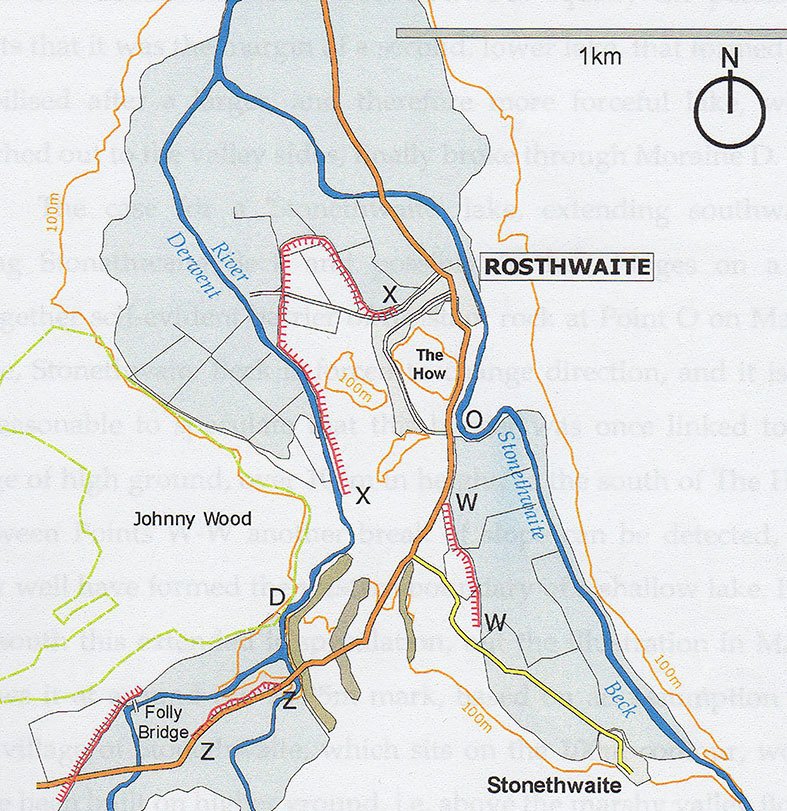
Essentially there are three moraines, and these are terminal moraines from the glacier that once occupied the valley of Stonethwaite Beck – see map below on which they are marked as A-A, B-B, and C-C.

Map 1: Showing three glacial moraines A-A, B-B and C-C
The content of these moraines is best seen at Point D on the map (Stage 2). Here the River Derwent is diverted northwards as it encounters the moraine, and is forced through a narrow constriction, causing substantial erosion to the moraine, exposing its contents where it has been undercut. Here the bedrock is exposed, but is not buried beneath glacial deposits. So, there must have been a time when the river flowing through the gap was substantially higher than the present. Evidence for this is the presence in the rock of small kettle holes, i.e. circular, bowl-like hollows formed in the rock by the erosional action of pebbles in the water.
The orientation of moraine A-A, being crescent-like and facing east indicates that it is a moraine of the glacier once present in Stonethwaite It is particularly evident to the south of the valley road, where it is topped by a drystone wall extending southwards to abut against the fellside beyond.
The retreat of the Borrowdale glaciers occurred in phases, and this is evidenced by yet more moraines – B-B and less obviously C-C. It can best be seen from near the church, when it appears as a low ridge extending northwards to meet the valley road.
Evidence for pro-glacial lake formation
The low-lying nature of the land south of the Jaws of Borrowdale clearly suggests that the land may well have been flooded in the past, and that it still floods from time to time.
Indicators that support the case for the presence of pro-glacial lakes are the several slope breaks that can be found in the area – see map below.
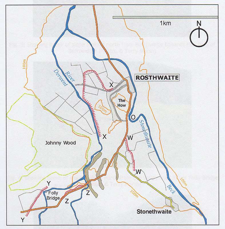
Map 2: Showing breaks of slope
The breaks of slope are not always evident, but show themselves particularly well at the northerly point X (Stage 1), Y and Z (Stage 3).
What these breaks of slope possibly indicate is a boundary formed by a lake or water action of some kind. That lakes may well have occurred here is supported by the frequently water-logged nature of the ground. But quite what shape and size they were is a matter of conjecture. Map 3 gives an indication of possibilities.
Map 3: Showing possible extent of pro-glacial lakes
The extent of these Borrowdale ‘lakes’ is not clear, but there is clearly defined high ground on which Rosthwaite is built, and a well-defined break of slope (X-X), which may well have formed the margins of the lake.
The coordinates take you to the parking area in Rosthwaite.
To claim this EarthCache, please do your best to answer the following questions. You will need to wander about a bit, so it is best to park at Rosthwaite, and figure out a safe route yourself. This is not an EC that you can do in a hurry, and vague answers that suggest that no serious attempt has been taken will not be accepted. So, take your time and enjoy the area. There are no ‘right’ answers, other than those that involve a measurement. The purpose of the EC is to help visitors to learn how to read the landscape.
1. At the northerly point X (Stage 1), look over the wall to identify a break of slope. What is the height of the slope, i.e. from top to bottom? How do you think this may have been formed – river or a standstill lake? What are your reasons for your answer?
2. Go to Point D (Stage 2), and examine the moraine opposite. Describe the contents as you see them. Is there anything about what you see that indicates water action?
3. Go to the gate at the more northerly Point Z (Stage 3), and examine the break of slope over the wall. Again, what would you say is the height of the break of slope, and what is its visible length?
4. While at Point Z, look SE across the road and you will see fairly level farmland that abuts the rising fell ground beyond. This farmland is marginally higher than that to the north of road, but it ends abruptly at the base of the rising ground in a shallow break of slope. Can you think of a reason for this, i.e. was it part of a larger, shallow lake, or was it caused by river action? Give reasons for your answer.
5. What does the presence of erratics on the top of Cat Bells and Maiden Moor (which you don’t need to visit), tell you about the direction of flow of the valley glaciers?
6. What modern-day evidence can you see, notably along the roadside, to suggest that the valley floods from time to time?
There is no obligation to add pictures, but if you have some good images of this special area, feel free to add them.