Español
La Serra do Courel, al Este de la provincia de Lugo, es un espacio natural singular en el que se reúnen características geológicas, botánicas y faunísticas únicas. Si en O Courel la biodiversidad es elevada, las riquezas arqueológica y etnográfica no se quedan atrás. Pero hoy vamos a centrarnos en un aspecto menos conocido, aunque fundamental para entender los anteriores: su geología. En este territorio montañoso de poco más de 21.000 hectáreas de extensión se encuentran algunos de los parajes gallegos incluidos en la lista Global Geosites, un inventario de lugares geológicos de relevancia mundial elaborado por la Unión Internacional de Ciencias Geológicas
El territorio Montañas do Courel se convirtió en 2019 en el primer geoparque de Galicia amparado por la Unesco.
A Fonte do Cervo
Denominada de forma popular A Fonte da Fame, tiene unas características muy especiales: de la misma roca brotan dos manantiales contiguos pero propiedades muy distintas, del de la izquierda brotan aguas calcáreas y del otro aguas ferruginosas.
Aguas subterráneas
El ciclo hidrológico comienza con la evaporación del agua de la superficie del océano. Cuando se eleva el aire húmedo, se enfría y el vapor de agua se condensa para formar nubes. La humedad se transporta alrededor del planeta hasta que vuelve a la superficie en forma de precipitaciónes. Una vez que el agua llega al suelo, uno de estos dos procesos pueden ocurrir;
1) una parte del agua puede evaporarse a la atmósfera
2) el agua puede penetrar en la superficie y se convierten en las aguas subterráneas.
Las aguas subterráneas son el agua encontrada bajo la superficie de tierra, contenida en los espacios dentro del suelo poroso y la roca. Las aguas subterráneas pueden ser obtenidas a partir de manantiales, perforaciones o pozos. Las rocas permeables tienen espacios diminutos entre las partículas de roca sólida, que permiten al agua y otros fluidos pasar y ser sostenida dentro de la estructura de la roca. Las rocas impermeables no tienen estos espacios y el agua no puede pasar por ellos.
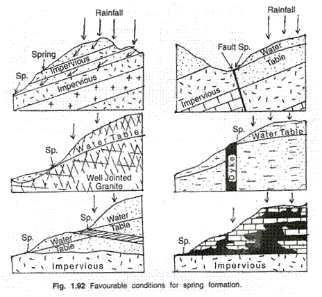
Manantiales
Un manantial surge en el punto donde el límite entre una capa permeable de roca subterránea y una capa impermeable alcanza la superficie. El agua de lluvia se filtra por el suelo dentro de la parte permeable del subsuelo o de la roca subterránea. La filtración se detendrá si esta capa de subsuelo permeable se asienta sobre la cima de una capa impermeable y el agua no puede avanzar más. Dependiendo de la pendiente de las capas, el agua correrá a lo largo de la cima de la capa impermeable a un punto donde esta alcanza la superficie y surge como un manantial.
Condiciones favorables para la formación de manantiales:
Aguas Ferruginosas
Las aguas ferruginosas, son las que contienen suficiente cantidad de hierro, para que este metal se pueda percibir al gusto y descubrir por el análisis. Al salir de la fuente, la mayor parte de estas aguas son claras y transparentes, inodoras, de sabor estíptico o parecido al de la tinta de escribir. Expuestas al contacto del aire, presentan en la superficie una película ferrugínea rojiza, ó irisada, y depositan, bajo la forma de copos amarillentos, cierta cantidad de protóxido de hierro
Para registrar este earthcache, enviame un correo electrónico con las respuestas para las siguientes preguntas:
1) ¿Cual es la orientación de los manantiales (N-S-SE-...) ? ¿A que altura del suelo estan?
2) ¿Por que piensas que el agua brota aqui, y no mas abajo?
4) Coje un poco del agua ferruginosa entre las manos, ¿Cual es su color? ¿Por que tiene ese color? Explicalo
5) Añade una fotografia tuya en el local, u otra en la que se pueda ver algún objeto, o tu nick en un papel
- Si piensa que a concluido con exito los objetivos de esta Earthcache y ya me envio todas las respuestas según lo pedido, por favor, proceda a logar el cache como encontrado, despues verificare las respuestas enviadas,y si es necesario, contactare con usted para efectuar las correcciones oportunas a su registro.
-Todos los logs sin respuestas seran apagados sin aviso.
English
Location
Serra do Courel, to the East of the province of Lugo, is a unique natural space in which unique geological, botanical and faunal characteristics are gathered. If in O Courel biodiversity is high, the archaeological and ethnographic riches are not left behind. But today we are going to focus on a less known aspect, although fundamental to understanding the previous ones: its geology. In this mountainous territory of just over 21,000 hectares there are some of the Galician sites included in the Global Geosites list, an inventory of geological sites of global relevance prepared by the International Union of Geological Sciences
The territory Mountains of Courel became in 2019 in the first geopark of Galicia protected by Unesco.
Fonte do Cervo
Popularly called "A Fonte da Fame", it has very special characteristics: two contiguous springs sprout from the same rock but very different properties, from the left springs calcareous waters and from the other ferruginous waters
Groundwater
The hydrologic cycle begins with the evaporation of water from the surface of the ocean. As moist air is lifted, it cools and water vapor condenses to form clouds. Moisture is transported around the globe until it returns to the surface as precipitation. Once the water reaches the ground, one of two processes may occur;
1) some of the water may evaporate back into the atmosphere
2) the water may penetrate the surface and become groundwater.
Groundwater is water found beneath the ground surface held in the spaces within porous soil and rock. Groundwater can be obtained from springs, boreholes or wells. Permeable rocks have tiny spaces between the solid rock particles that allow water and other fluids to pass through and be held within the rock structure. Impermeable rocks do not have these spaces and water cannot pass through them.
Springs
A spring occurs at the point where the boundary between a permeable layer of underground rock and an impermeable layer reaches the ground surface. Rainwater percolates through the soil into permeable layers of subsoil or underground rock. The downward percolation will be stopped if this layer sits on top of an impermeable layer and the water can go no further. Depending on the slope of the layers, the water will run along the top of the impermeable layer to a point where it reaches the surface and emerges as a spring
Favourable conditions for spring formation:
Ferruginous Waters
Ferruginous waters, are those that contain enough iron, so that this metal can be perceived to taste and discover by analysis. When leaving the source, most of these waters are clear and transparent, odorless, with a stylistic or ink-like flavor. Exposed to the contact of the air, they present on the surface a reddish or iridescent ferruginous film, depositing, in the form of yellowish flakes, a certain amount of iron protoxide.
To log this earthcache, send me an email/message with the answer to the following questions:
1) What is the springs orientation (N-S-SE -...)? At what height of the ground are they?
2) Why do you think that water flows here, and not below?
3) Take a little of the ferruginous water between your hands, what is its color? Why does it have that color? Explain it
4) Add a photo of yourself at the place, or another in which you can see an object, or your nick on a piece of paper
-If you believe you have successfully completed this Earth Cache goals and has already sent to me all the requirements as requested, Please, feel free to log it as found. Later i will verify the requirements sent and, if necessary, contact you in order to make the necessary corrections to your log.
-Logs without answers, will be deleted without notice.
Fuentes:
-Percorrido xeoloxico pola Serra do Courel
-Wikipedia |
