Look-Off, Annapolis Valley
The Annapolis Valley is a valley and region in the Canadian province of Nova Scotia. It is located in the western part of the Nova Scotia peninsula, formed by a trough between two parallel mountain ranges along the shore of the Bay of Fundy.
The Annapolis Lowland, (more commonly known as the Annapolis Valley) measures approximately 126 kilometres (78 mi) in length from Digby and the Annapolis Basin in the west to Wolfville and the Minas Basin in the east, spanning the counties of Digby, Annapolis and Kings and is about five miles wide.
From this marshy divide the Annapolis River, 43 miles long, flows westward to the Annapolis Basin, and the Cornwallis River, 19 miles long, flows eastward to the Minas Basin. The two rivers, therefore, have gradients of 3 ft./ mile and 6.5 fUmile respectively. The Annapolis Valley, mantled in large part by stratified glacial drift, is agricultural land and therefore heavily populated relative to the adjacent uplands.
Geologically founded upon weak, mainly red, sedimentary rocks of Triassic age (250-205.7 million years old), its elevation ranges from sea level at its western and eastern ends to about 35 m in the centre, rising to about 60 m on north and south flanks. The lowland is overlooked on the north by the basalt-capped escarpment of North Mountain, which rises to 180-240 m, and on the south by the granite upland of South Mountain, rising to 150-210 m.
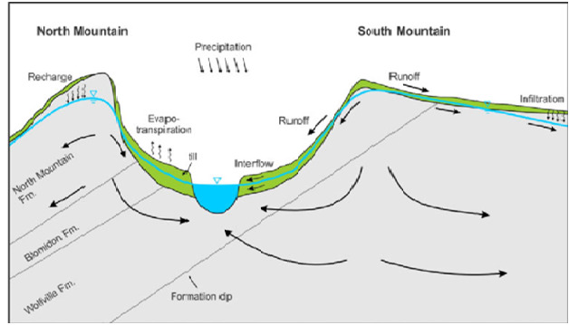
North Mountain:
The steep face of basaltic North Mountain shelters the valley from the adjacent Bay of Fundy and rises over 260 metres (850 ft) in elevation near Lawrencetown and forms the north side of the Annapolis Valley .The North Mountain lava flows are basaltic; some flows are massive; about two-thirds of the flows, however, contain zeolitic amygdules.
South Mountain:
The granitic South Mountain rises to a somewhat higher elevation and shelters the valley from the climate of the Atlantic Ocean approximately 100 kilometres further south on the province's South Shore. This southern upland has a granite core, a batholith 125 miles long and up to 50 miles wide, which forms the axis of the Nova, Scotian peninsula. The northwest flank of this southern highland is underlain by tightly folded Paleozoic sediments into which the granite intruded in late Devonian time. The contact between the granite and the Paleozoic sediments is locality discordant, but the general trend is NE-SW parallel to the Annapolis Valley, to the axis of North Mountain, and to the shore of the Bay of Fundy. Along the base of South Mountain the Paleozoic formations pass under the Triassic sediments of the Annapolis Valley with angular nonconformity.
The shelter provided by these two mountainous ridges has produced a "micro climate" which provides relatively mild temperatures for the region and, coupled with the fertile glacial sedimentary soils on the valley floor, the region is conducive to growing vegetable and fruit crops. Particularly famous for its apple crop, the valley hosts in excess of 1,000 farms of various types, the majority being relatively small family-owned operations.
Following the retreat of glacial ice, about 13 000 years ago, the lowlands were nearly completely flooded by the sea to a height of 30 m. Subsequent isostatic uplift caused withdrawal of the sea, but in the last 6000 years sea-level rise has led to the growth of extensive salt marshes at each end of the lowlands, through which the Annapolis and Cornwallis rivers flow in broad meanders.
These marshes were the focal area of Acadian French settlement from the founding of Port-Royal (1605) to the mid-18th century. Dikes were built by Acadians to regulate tidal flooding of the marshes and to permit their drainage for use as rich hayfields. Towards the centre of the lowlands, well-drained, stone-free soils on undulating topography free of spring frosts form the basis of apple orchards and dairy farming.

To log this earthcache please answer the following questions and send in a timely manner to my geocaching profile or email. Answers not received will result in deleted logs.
1. What is the height of the land at the earthcache coordinates?
2. Take a reading on the valley floor to compare.
3. Why do you think the Annapolis Valley is such a rich farmland?
4. Name a few crops that the valley is known for.
5. Post a picture of the view.
[REQUIRED] In accordance with the updated guidelines from Geocaching Headquarters published in June 2019, photos are now an acceptable logging requirement and WILL BE REQUIRED TO LOG THIS CACHE. Please provide a photo of yourself or a personal item in the picture to prove you visited the site.