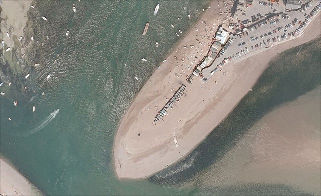
Denn Spit
The town of Teignmouth is built on Denn Spit at the entrance of the Teign estuary. The point at Teignmouth (see image below) is just the far end of the much bigger Denn Spit. Here at the posted coordinates you are standing on the very tip of the much larger Denn Spit.
Coastal landforms
Coastal landforms can be either depositional or erosional. Beaches and spits are examples of depositional landforms. A further depositional coastal landform is a tombolo, the name given to a spit that joins an island to the mainland. Cliffs and caves are examples of erosional landforms.
Longshore drift
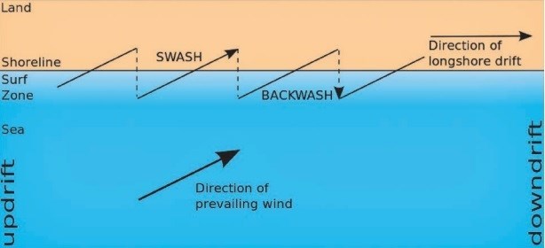
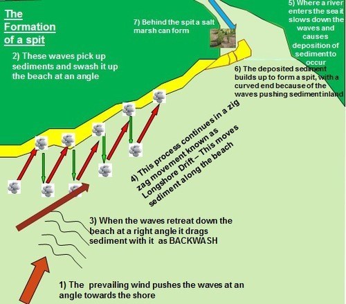
Sediment is carried in the sea parallel to the coastline by the process of longshore drift. This occurs due to waves meeting the beach at an oblique angle, moving sediment down the beach in a zigzag pattern.
Spit formation
Spits are created by deposition of sediments suspended in the sea. A spit is an extended stretch of sand or shingle jutting out into the sea from the land. Spits occur when there is a change in the shape of the landscape or there is a river mouth. This change in shape of the coastline interrupts longshore drift by causing the water to lose energy and slows down. As it does so, any sediment it is carrying is deposited.
Coastal geology and geography around Teignmouth
The coastline north and south of Teignmouth has many cliffs formed of distinctive reddish sandstone and breccia giving a pattern of small bays, or coves, and intervening headlands. The Italian word breccia means rubble, typically as used in road building. The breccias found in Devon are formed of angular gravels embedded in red sand. Longshore drift south of the Teign estuary is from south to north and rather weak. Between northern Teignmouth and the far end of Denn spit (where you are standing) the drift is from north to south. Much further north, across the entrance to the River Exe, south to north longshore drift has created the enormous spit of Dawlish Warren.
To log this EarthCache go to the posted coordinates (the exact position is not relevant) and answer the following questions.
1. Look at the sand you are standing on. Describe the appearance of the sand. (Colour? Coarse or fine? Describe the pebbles.)
2. What do you think is the origin of this sand?
3. Why do you answer question 2 in that way?
4. What do you think is the most likely reason(s) for the spit here to form on the north side of the river, while just a few miles north at Dawlish the spit is on the south side of the river? (ie, speculate why the longshore drift is in a different direction - no need to worry about a "correct" answer, just give reasons for your suggestion)
5. (Optional) Please add a photo of you and/or your group here.
Send me your answers either via my profile or via the messaging geocaching.com (Message Center), but please log this cache "Found it" before hearing back from me. I will contact you if there is a problem.