Cache is not at the posted coordinates. You will need to visit three stages to find necessary information for the final location with the cache.
One time I found a book Saskatoon - A Century in Pictures which had lots of interesting photos of different periods of time in this city. I wanted to share some history of the streets of Saskatoon.
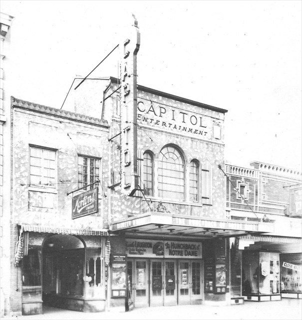
Posted coordinates is just a virtual stage, you don't need to visit it to obtain information. Coordinates are showing where The Capitol Theatre used to be, constructed on Second Avenue in 1929, one of the large luxurious theatres built in major centers across the country to usher in "talking" films. It also served the city as an auditorium and concert hall for many years.

Public demonstration in May, 1979. On the fiftieth anniversary of the Capitol Theatre, local community action groups held a "birthday party" to protest plans for demolition of the theatre, but to little avail, for it came under the wrecking ball later that year.
Stage 1

July 4, 1913. Saskatonians of American origin paraded on Twenty-first Street, at the time a dirt street with board sidewalks. All the buildings shown, except the bank on the right, are still standing today. Make your way to N 52° 07.617 W 106° 39.834 and you'll find the building from the photo that has J.F.Cairns sign on the side. Look up in front of the building and you will see a four digit number. That's your ABCD.
Stage 2

The busy intersection at Second Avenue and Twenty-first Street in 1958. Motorists whose cars did not have signal lights were required to signal by hand. The first traffic light in the city had been installed at this intersection in 1946. Look at the photo and find the spot under a hanging sign - on the right side of the corner building, next to Sobies. Visit that spot located at N 52° 07.651 W 106° 39.876 and you'll see three rather big digits on the wall. That's your EFG.
Stage 3

The fiery destruction of the Drinkle No 1 Building in 1925. Before the First World War, the University of Saskatchewan held classes in this building.

Fire happened at the end of January, when it was cold with temperatures of -22C and below. Drinkle Block suffered devastating fire, here shown with icycles resulting from water from firemen's hoses. Rebuilt and renamed the MacMillan Building, it now stands at the corner of Second Avenue and Twenty-first Street. Make your way to N 52° 07.631 W 106° 39.910 and on one of the entrance walls you'll see a date and a name. The date is your HIJK.
Final location
The cache is located at N 52° 07.(D)(J)(K-2) W 106° 39.(G)(E)(D+1). Please use stealth as it can be rather busy with muggles.
Check your solution: A+B+C+D+E+F+G+H+I+J+K=46.