La Earthcache / The Earthcache
Parce qu'il n'y a pas que le grès vosgien en Alsace...
Cette petite série de caches géologiques a pour objectif de permettre la découverte sur le terrain de la richesse géologique du Centre Alsace et d'avoir un court aperçu de son histoire tumultueuse qui a aboutit à la mise en place de cette diversité de roches et des phénomènes tectoniques majeures dont cette région a été l'objet au travers des Ages.
Ce septième épisode va partir à la découverte d'une formation rocheuse sédimentaire du Mésozoïque caractéristique de la colline sous-vosgienne du Florimont, le Calcaire du Muschelkalk.
► Contexte géologique local
Le site géologique du Florimont est un ensemble de deux collines, le Sommerberg (382 m) et le Dorfbourg (308 m) situé à l'extrémité Sud du champ de fractures de Ribeauvillé.
L'observation de la carte géologique dévoile une grande diversité de formations constitutives de l'histoire géologique des Vosges et du fossé rhénan avec des couches allant de -320 Ma à -30 Ma.
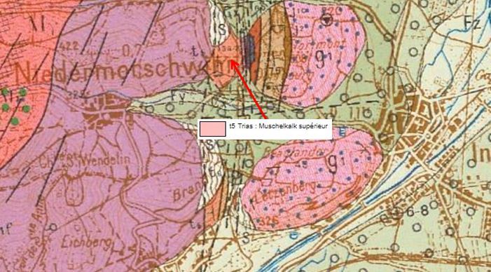
L'une de ces formations a une position centrale, il s'agit de la formation "t5. Muschelkalk supérieur", qui se subdivise en deux unités lithostratigraphiques :
- Calcaire à entroques à sa base (8-10 m d'épaisseur)
- Calcaire à cératites au dessus (45 à 50 m d'épaisseur)
► Les calcaires du Muschelkalk
Le Muschelkalk (ou calcaire coquillier) désigne une partie des strates du Trias moyen datées d'environ -235 Ma à -245 Ma.
Elle est formée de deux formations différentes, s'expliquant par une variation des conditions de dépôt.
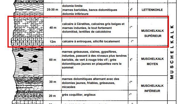
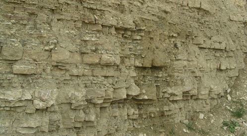
~ Le Calcaire à entroques
Le calcaire à entroques est massif, compact, de couleur gris-beige devant jaune sale par altération, disposé en bancs métriques.
Il ne présente aucune forme de stratification.
Son grain est très fin, constitué de carbonates micritiques invisibles à l'oeil nu.
La micrite est une boue carbonatée ou une calcite très finement cristallisée (cristaux de calcite entre 1 et 4 µm) constituant tout ou partie de certaines roches carbonatées.
Cette formation s'est mise en place dans un domaine marin restreint de type lagon, peu profond dans lequel se déposent les carbonates fins et micritiques très bioturbés.
Il présente un aspect bréchique bien visible, en rapport avec l’agitation de l’eau peu profonde lors du dépôt dans une zone récifale, riche en encrines et soumise à de brusques variations des niveaux d'eau à la suite de tempêtes.
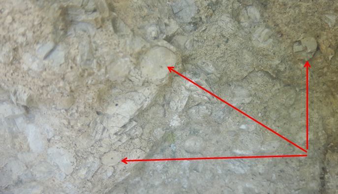
Ce calcaire se caractérise par la présence d'un fossile stratigraphique, l'encrine.
Cet Échinoderme (crinoïde) du Trias était fixé au fond de la mer par une longue tige, composée d'articles en entroques, rappelant l'empilement des vertèbres de la colonne vertébrale.
Il peut se présenter sous une forme fossile entière, mais est plus généralement repérables par des restes sous la forme d'entroques (des articles constituant la partie solide du pied de la tige).
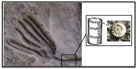
Dans le Calcaire à entroques du Muschelkalk, ces entroques ont généralement connus une silicification, transformant leur composition chimique de carbonatée à silicifiée.
~ Le Calcaire à cératites
Le calcaire à Cératites est une formation plus litée, moins massive, avec une alternance de bancs de marnes tendres (dépôt de boues argileuses) et de calcaires plus indurés, constitués de dépôts de calcite et de fossiles carbonatés.
Cette formation s'est mise en place dans un domaine marin ouvert caractérisé par des alternances marnes/calcaires du Calcaire à cératites, les marnes représentant la sédimentation en eau calme, tandis que les bancs à cératites représentent des épisodes tempétueux.
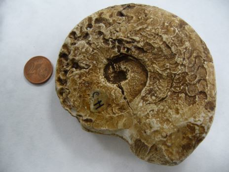
Ce calcaire est également caractérisé par un fossile stratigraphique, la cératite.
Il s'agit d'un mollusque céphalopode marin qui s'est particulièrement développé au Trias, et qui se caractérise par une coquille spirale à lobe simple.
Because there is not only the Vosges sandstone in Alsace ...
This small series of geological caches is intended to allow the discovery on the ground of the geological wealth of the Alsace Center and to have a brief overview of its tumultuous history which has led to the establishment of this diversity of rocks and phenomena major tectonics of which this region has been the object through the Ages.
This seventh episode will begin to discover a Mesozoic sedimentary rock formation characteristic of the Florimont hill, Muschelkalk Limestone.
► Local geological context
The Florimont geological site is a set of two hills, the Sommerberg (382 m) and the Dorfburg (308 m) situated at the southern end of the Ribeauvillé fracture field.
The observation of the geological map reveals a great diversity of formations constituting the geological history of the Vosges and the Rhine ditch with layers ranging from -320 Ma to -30 Ma.
One of these formations at a central position is the formation "t5 Upper Muschelkalk", which is subdivided into two lithostratigraphic units:
- Limestone with crinoidal articles at its base (8-10 m thick)
- Limestone with ceratites above (45 to 50 m thick)
► The limestones of Muschelkalk
The Muschelkalk (or shell limestone) refers to a portion of the Middle Triassic strata dated from about -235 Ma to -245 Ma.
It is formed of two different formations, explained by a variation of the deposit conditions.
~ Limestone with crinoidal articles
The limestone with crinoidal articles is massive, compact, gray-beige in front of dirty yellow by alteration, arranged in metric banks. It has no form of stratification.
Its grain is very thin, consisting of micritic carbonates invisible to the naked eye.
The micrite is a carbonate sludge or calcite very finely crystallized (crystals of calcite between 1 and 4 microns) constituting all or part of some carbonate rocks.
This training was set up in a narrow marine lagoon-type, shallow area in which the very bioturbated fine and micritic carbonates are deposited.
It has a conspicuous breccia appearance, related to the agitation of shallow water when deposited in a reef zone, rich in encrines and subject to sudden changes in water levels following storms.
This limestone is characterized by the presence of a stratigraphic fossil, encrine.
This echinoderm (Crinoid) of the Triassic was fixed at the bottom of the sea by a long stem, composed of articles in crinoidal articles, recalling the stacking of the vertebrae of the vertebral column.
It may be in a whole fossil form, but is more generally detectable by remains in the form of crinoidal articles (articles constituting the solid part of the foot of the stem).
In the Intercropped Limestone of Muschelkalk, these crinoidal articles have generally been silicified, transforming their chemical composition from carbonate to silicified.
~ Limestone with ceratites
Ceratite limestone is a more bedded, less massive formation with alternating soft marl (clay loam deposit) and more indurated limestone deposits consisting of calcite deposits and carbonate fossils.
This training was set up in an open marine area characterized by marl / limestone alternation of limestone with ceratites, the marl representing sedimentation in calm water, while the schools with ceratites represent stormy episodes.
This limestone is also characterized by a stratigraphic fossil, the ceratite.
It is a marine cephalopod mollusk that has developed particularly in the Triassic and is characterized by a spiral shell with a simple lobe.
► Sources bibliographiques / Bibliographical sources
Les Questions / The Questions
La lecture attentive du descriptif de la cache, ainsi qu'une observation des éléments de terrain et un peu de déduction sont normalement suffisants pour répondre aux questions de cette EarthCache.
A careful reading of the description of the cache, as well as observation of terrain features and some deduction is usually sufficient to answer questions of this EarthCache.
Questions pour valider :"Les Calcaires du Muschelkalk à Florimont"
Questions to validate: "Limestones from Muschelkalk in Florimont"
Après avoir attaqué l'ascension de la colline du Sommerberg à partir du TrealHead 1 (N 48° 06.038 E 007° 17.132) puis tourner à gauche au TrealHead 2 (N 48° 06.097 E 007° 17.198), vous longez les parcelles de vignes jusqu'à arriver devant un affleurement près d'une cabane en bois (voir photo WP1).
After having climbed the Sommerberg hill from TrealHead 1 (N 48 ° 06.038 E 007 ° 17.132) then turn left at TrealHead 2 (N 48 ° 06.097 E 007 ° 17.198), you follow the vineyard parcels to arrive in front of an outcrop near a wooden hut (see photo WP1).
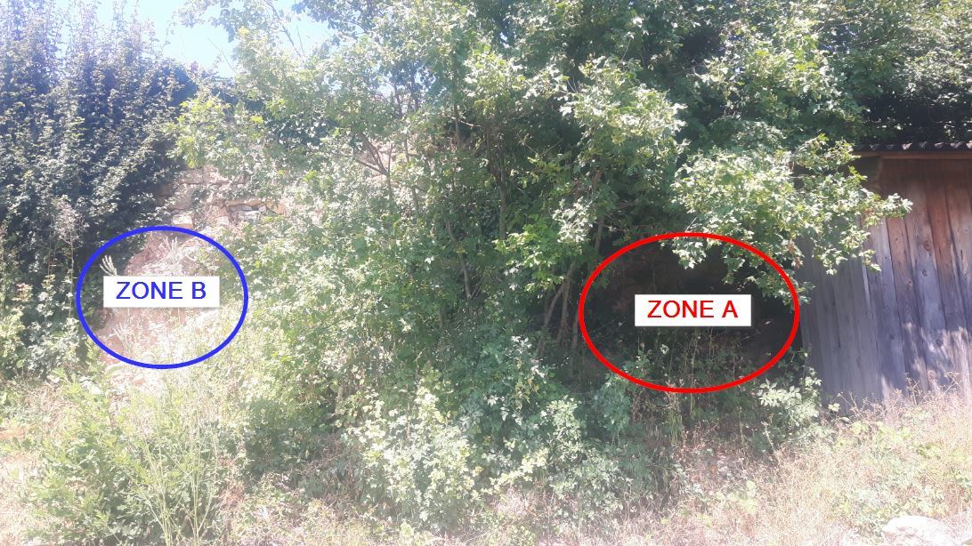
- Question 1 : Décrire l'affleurement de la zone rouge A selon les critères suivants : couleur ; roche massive ou litée ; taille des grains ; Dureté de la roche. En déduire la nature de cette roche.
- Question 1 : Describe the outcrop of the red zone A according to the following criteria: color; massive rock or bed; grain size; Hardness of the rock. Deduce the nature of this rock.
- Question 2 : En fonction de la taille des grains formant cette couche géologique et en utilisant le descriptif, comment pouvez-vous qualifier sa texture ?
- Question 2 : Depending on the size of the grains forming this geological layer and using the description, how can you qualify its texture?
Décalez vous de quelques mètres à gauche et observez de près les blocs de roche de la zone bleue B.
Shift a few meters to the left and look closely at the blocks of rock in blue area B.
- Question 3 : Vous pouvez voir des éléments bien visibles parsemer la fine matrice de calcite. Décrire ces éléments : couleur, taille, forme. De quoi s'agit-il ? En quoi la présence de ces éléments confortent-elles l'identification de la nature de cette formation ?
- Question 3 : You can see some conspicuous elements from the fine calcite matrix. Describe these elements: color, size, shape. What is it about ? How do the presence of these elements support the identification of the nature of this training?
Vous pouvez vous loguer sans attendre notre confirmation,
mais vous devez nous envoyer les réponses en même temps soit par mail via notre profil (
fafahakkai), soit via la messagerie geocaching.com (Message Center).
S'il y a des problèmes avec vos réponses nous vous en ferons part.
Les logs enregistrés sans réponses seront supprimés.Une photo de vous ou de votre GPS avec le Dorfbourg (l'autre colline du Florimont) et les vignes en arrière plan est la bienvenue, mais n'est pas obligatoire.
You can log this cache without waiting for our confirmation, but you must send us the answers at the same time, by e-mail via our profile (fafahakkai) or by the system of Message Center of geocaching.com.
If there is a problem with your answers we will notify you. The logs recorded without answers will be deleted.
A photo of you or your GPS with the Dorfburg (the other hill of Florimont) and the vines in the background is welcome, but not mandatory.
Rappel concernant les « Earthcaches »: Il n'y a pas de conteneur à rechercher ni de logbook à renseigner. Il suffit de se rendre sur les lieux, de répondre aux questions ci-dessus et de nous renvoyer les réponses.
Reminder concerning "Earthcaches": there is neither a container to look for nor a logbook to sign. One need only go to the location, answer to the differents questions and send us the answers.