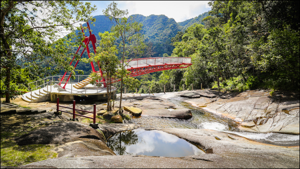
Known locally as Telaga Tujuh, the Seven Wells Waterfall is named after the seven natural pools that have been formed at different levels by water streaming down Langkawi's second highest mountain, Mount Mat Cincang. It is arguably the most picturesque and best waterfall on the island.
Type of Earthcache: Denudation (Erosion).
About solution cavities, potholes and chimneys
Solution cavities come in all shapes and sizes and they can develop anywhere in or on a rock where water persistently accumulates. Their size determines whether they are referred to as solution cavities, potholes or chimneys. Larger examples include caves, caverns, sinkholes and dolines.
The geological landscape at the Seven Wells Waterfall was formed along a river with a gap of height created by fault movement that created a waterfall. Upstream, flowing water formed seven potholes in the Sawar Granite, from which the location derived its name. Seasonal differences create different circumstances which can lead to different conclusions as to how these potholes have formed.
During the dry season, several potholes contain stagnant water filled with green algae, suggesting the potholes were created through solution. Regardless how slow, rock dissolves under the action of rainwater or groundwater charged with H2CO3 (carbonic acid) and naturally occurring organic acids.
During the rainy season, the same potholes become active with a strong current flowing over them. This current moves pebbles and other debris, abrading materials that are called grinders, found on the bottom of these potholes, allowing it to act like a screw to bore the rock. This suggests that these potholes have been created by abrasion instead.
Diameters of the potholes range from 1.5m to 5m with depth from 30cm to 1.5m. At this point, it is interesting to mention that larger vertical potholes, or chimneys, with a depth of more than 2 metres, would contain a stagnation zone, whereby the water at the bottom can be near still and sediments would remain relatively undisturbed under any condition. This in turn suggests that, from a certain depth onward, any deepening would be by solution and not abrasion.

Seven Wells Waterfall / Telaga Tujuh.
How to claim this EarthCache?
For this EarthCache, we will focus on one particular pothole. It is easily identified from the given coordinates (bridge). Looking upstream, it is the raised round pothole on the right bank of river.
Send me the following;
1. The text "GC81GQ3 Seven Wells - Potholes" on the first line.
2. The answers to the following questions;
- Do you think this pothole has been created by solution or abrasion? Explain why.
- How many potholes, excluding smaller solution cavities, can you identify?
- Take a closer look. Describe what you see when you look into the pothole.
- How does this pothole differ with the one located right next to it?
3. Provide a photo of yourself or a personal item to prove you have visited the site.*
References
* Effective immediately from 10 June 2019, photo requirements are permitted on EarthCaches. This task is not optional, it is an addition to existing logging tasks! Logs that do not meet all requirements posed will no longer be accepted.
For additional information, visit; Geosociety.org, Geocaching.com Help Center and Geocaching.com Forum.
