Although you may be able to access this container during the winter months, it may be difficult to appreciate the concept of this geocache if the stream is frozen over, which is typical between November and early April.
Have you ever wondered how much water is flowing in that fantastic creek along which you are hiking? In Colorado, we all know that the flow varies from a maximum during spring runoff of the melting snow to a minimum during the late summer and fall, depending on the recent monsoon rainfall. The amount of flow is very important to understanding drought cycles and water rights downstream. The calculation of flow is quite simple in theory, but is complicated in practice. The equation for flow is:
Q = V times A
where
Q is the flow rate (in cubic feet per second),
V is the velocity of the water (in feet per second),
A is the cross-sectional area (in square feet) of the channel where the velocity is measured.
While this calculation is simple in a pipe with water flowing under constant conditions, the flow in a creek is more complicated by the variation in the width and depth of the creek, as well as the changes in flow direction and velocity in changes of creek direction and due to obstacles (rocks) in the flow path. Flow of water on the earth’s surface in a ditch or channel is referred to as open-channel flow, because there is a constant atmospheric pressure at the water/air interface, as opposed to a pipe where it is possible to build up a different pressure than atmospheric pressure. And you must remember that the pressure in the water increases with depth from the surface because gravity acts more strongly on the denser water than the air.
While working at the U.S. Soil Conservation Service, Colorado State University professor Dr. Ralph L. Parshall saw a need for more accurate measurement of surface waters – in particular irrigation / water rights flows. At that time, weirs or Venturi flumes were used to measure flow, but both devices had shortcomings. Starting in 1915 with the sub-critical Venturi flume, Dr. Parshall made a series of modifications, ultimately leading to an improved geometry.

The critical improvement that Dr. Parshall introduced was a drop in the floor in the throat section of the flume. The constriction of the throat creates the water depth to flow relationship and by sloping the floor down here, the resulting flume is able to withstand relatively high degrees of submergence without affecting the flow rate. This allows only one measurement to be needed to determine the flow rate through the flume – greatly simplifying the determination of the flow rate.
Six years after his work began, Dr. Parshall filed a patent for his new “Parshall Flume”. Over the years, Dr. Parshall’s work has been extended to flumes both larger and smaller than his original investigations. Currently there 22 sizes of Parshall flume recognized and standardized. This device is widely used throughout the world. It is an accurate and economical device for the measurement of open channel flows in a variety of applications, including:
- Watershed monitoring
- Edge-of-field runoff
- Stream gauging
- Dam seepage
- Irrigation canals
- Spring discharge measurement
- Sewage treatment plants
- Industrial discharge monitoring
- Mine discharge
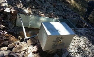
The flume here on Black Mountain Creek has a 2 foot throat width, and is two feet deep, and can measure the flow of clean water to an accuracy of about 2% over its design capacity range. The actual equation of free flow for this device vs. depth of water at the inlet measurement point (where there is a ruler installed) is:
Q = K times (Ha)n
where
K = flume discharge constant = 8 (for this particular size flume)
Ha = liquid depth at measurement point
n = discharge exponent (for this particular size flume) = 1.55
With this equation, and only one real-time measurement of liquid depth (Ha), it is possible to measure the flow in Black Mountain Creek. The result is presented in the following graph:

Usually the flume is designed for free flow which is not restricted by downstream conditions. However, over time, growth of vegetation downstream or new flow obstruction there can affect the ability of the water to leave the flume. To allow for reasonable accurate measurement under these changed conditions, another water depth measurement location Hb was defined, and it comes into play when the ratio of Hb/Ha (submergence) reaches 0.7 and above. A different, but more complex equation can be used to correct the flow rate between submergence values of 0.7 and 0.9. Above a submergence of 0.9, the flow data becomes increasingly overstated, and cannot be reliably used because of the accuracy of the more complicated equation. But that is probably more information than you wanted to know. If you want more info, you can see Open channel flow.com
By the way, the maximum standard height measurement for this 24” wide flume is 2.5 feet, and this device was not built to take advantage of the maximum depth, so probably the expected flow was not as high as the 33.11 cubic feet per second that a 2.5 foot depth would measure. It is also possible that these higher flow rates were considered free river flow for this creek, and did not have a legal consequence. And since this flume does not have a screen upstream to trap debris, the flow measurement could be disrupted by a floating branch or bark that gets trapped in the converging section. Another problem in the winter is ice buildup on the water surface that can interfere with the depth measurement. (photo below)

While we are discussing the measurement of water flow, it is useful and relevant to put the legal water rights in Colorado in perspective.
Colorado Water Law and its Development
Several factors were important in the development of the existing rules for water use in Colorado:
A) Early settlers realized that Colorado does not receive much precipitation, and the precipitation that does accrue does so in the form of snow in the mountains, which creates overflowing conditions on streams during the spring with dwindling supplies throughout the rest of the year. Therefore, any water allocation system to be developed had to take the environment into consideration and be different from those utilized in areas that normally receive adequate year-round precipitation.
B) After the gold rush of California in the late 1840s, many people in California returned to Colorado to take a stab at striking it rich in Colorado, and with them, brought ideas used in California to settle arguments over land, and eventually water. Mining is very water intensive, for both sluice gates and high-pressure water (placer) mining, and over time there were disputes from miners along a given waterway on property ownership and eventually water rights. To settle such disputes, Miner's Courts were established as they were in California. Originally created to settle disputes over land ownership, Miner's Court developed the theory that if you were on the land first, it was your land or claim, and those following had no right to it (thus, first in time, first in right). The system was eventually transferred to water ownership disputes. The first to beneficially use the water that was needed, owns that amount of water, and the second one beneficially using the water gets what is left (if any).
C) With little water available from rainfall, water had to be used directly from stream systems. If the only persons allowed to use such water were those next to the stream (riparian) very little land could be utilized for agricultural development. Early in Colorado history, most crops were only grown near streams. However, economic conditions in the east eventually lead to a foreseeable profit in the growing of cash crops if only more acreage could be developed. Thus, developers began colony settlements such as the Union Colony (Greeley) and the Fort Collins Agricultural Society to foster such acreage production. These companies would build canals from the main stem of the river and give a share of the water to a farmer to irrigate fields previously not irrigated (Precursors to mutual ditch companies).
During abundant water supply times all was well, but when drought occurred, water users found themselves at odds and without water. Violence erupted resulting in the Water Wars of 1874, which in turn eventually led to Article XVI of the Colorado Constitution enacted in 1876, when Colorado was granted statehood. Sections 5 and 6 of Article XVI, provides:
5. Water of streams public property. The water of every natural stream, not heretofore appropriated, within the State of Colorado, is hereby declared to be the property of the public, and the same is dedicated to the use of the people of the state, subject to appropriation as herein provided.
6. Diverting unappropriated water priority of preferred uses. The right to divert the unappropriated waters of any natural stream to beneficial uses shall never be denied. Priority of appropriation shall give the better right as between those using water for the same purposes; but when the waters of any natural stream are not sufficient for the service of all those desiring to use of the same, those using the water for domestic purposes shall have the preference over those claiming for any other purpose, and those using the water for agricultural purposes shall have preference over those using the same for manufacturing.
The basic tenant of the Colorado appropriation system to be remembered is "first in time, first in right." An appropriation is made when an individual physically takes the water from a stream and transports it to another locale for beneficial use. The first person to appropriate water and apply that water to a beneficial use has the first right to use that water within a particular stream system. The senior water right user, or first appropriator, must then be satisfied before any other junior rights are fulfilled.
Beneficial use is defined under section 37-92-103(4), Colorado Revised Statutes as “the use of that amount of water that is reasonable and appropriate under reasonably efficient practices to accomplish without waste the purpose for which the appropriation is lawfully made”. Without limiting the generality of the previous sentence, beneficial use includes:
(a) The impoundment of water for firefighting or storage for any purpose for which an appropriation is lawfully made, including recreational, fishery, or wildlife purposes;
(b) The diversion of water by a county, municipality, city and county, water district, water and sanitation district, water conservation district, or water conservancy district for recreational in-channel diversion purposes; and
(c) For the benefit and enjoyment of present and future generations, the appropriation by the state of Colorado in the manner prescribed by law of such minimum flows between specific points or levels for and on natural streams and lakes as are required to preserve the natural environment to a reasonable degree.”
This summary of Colorado Water Law is derived from Synopsis of Colorado Water Law
Impact on Staunton State Park Development
The land where Davis Ponds now sit was homesteaded by W. Dougherty in 1892, and had previously been owned by the Federal government. In 1892, the population of the city of Denver was about 110,000 people, and the water supply for them and the burgeoning farms on the plains of eastern Colorado was a major operation. Since Black Mountain Creek is a tributary of the North Fork of the South Platte River, which runs through Denver, most of the water flowing down the creek was already being used for other beneficial purposes downstream. The later owners of the land developed a series of three ponds for farm use, with each pond having an earthen dam. When the State bought the land for development of the State Park in 1999, the sale included some water rights, but they dated from no earlier than 1892. So when it was determined that the earthen dams did not meet current safety requirements for public use, the ponds were reconstructed in 2012-2013 into two ponds with the same storage capacity of the original three ponds. The dams now in place are a much more industrial design which can withstand periodic major floods and seismic events. During the construction phase, the three ponds were drained and the stored water allowed to go downstream. When it was time to refill the two ponds behind the new dams, the filling had to be delayed somewhat due to demands for water allotments from downstream users that were more senior than the water rights of the owner of the land where the ponds are located. The key piece of information that influenced the timing was the flow data provided to the State Engineer by this flume upstream of the ponds.
 This cache is located within Staunton State Park, which has one public entrance along S. Elk Creek Road, six miles west of Conifer, about 1.5 miles off U.S. Highway 285. Parking along either side of S. Elk Creek Road and Upper Ranch Road adjacent to the park boundary is prohibited. All vehicles entering the park must have a daily park pass ($10) or a CO state park annual or special pass.
The Park is open year-round, and day use hours at 6:00 am to 10:00 pm. A walk-in campground (up to 1/4 mile from parking) is open for public use, and overnight parking is currently permitted only for those staying in the campground. During summer and autumn weekends, the park may reach capacity, and cars are allowed to enter only if a parking space is available. Horse trailers are admitted if space is available for parking trailers,in the new, dedicated, unpaved parking lot. All Park trails are natural surface, some trails are hiker-only, but other trails are multiuse for bicycles and horses also. Information about the park can be found at Staunton State Park website
All visitors must follow park rules and regulations. These include dogs on leash at all times, clean up after pets, travel on developed trails to the extent feasible, leave no trace, respect areas closed for resource management, and be careful around wildlife (especially mountain lions, coyotes, and black bears). Fires are strictly prohibited, except for camp stoves with an on/off switch in the designated campsites and grilles found in the picnic areas. No motorized vehicles are allowed on trails within the Park. An exception is the special tracked chairs that the Park offers to visitors who cannot access selected trails on their own mobility. Pack your own trash out of the back country, and trash receptacles are located near the parking areas. Also, be prepared for changing weather, bring adequate water and footwear, and trails may be snow-covered or icy in winter.