 Les Earthcaches

 Je vous propose de venir vous promener sur le chemin de Halage, le long de la Mayenne...
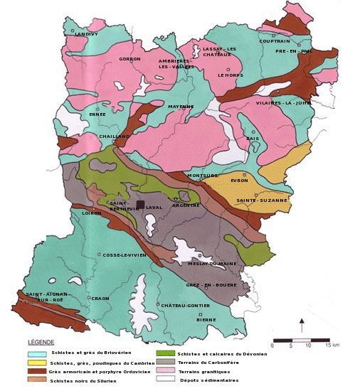
Géologiquement, le département de la Mayenne est semblable à la Bretagne, puisque dans le prolongement du Massif armoricain ; comme celui de cette région la plupart de ses roches, granites, porphyres, schistes, grès paléozoïques, sont d'origine ancienne ; les granites bleus et les prophyres des Coëvrons sont surtout remarquables.

I suggest you come for an hike on the Halage path, along the Mayenne...
Geologically, the department of Mayenne is similar to Brittany, since in the extension of the Armorican Massif; like that of this region most of its rocks, granites, porphyries, schists, Paleozoic sandstones, are of ancient origin; the blue granites and the prophets of the Coevrons are especially remarkable.
Rappel géologique :
L'ensemble du territoire mayennais fait partie du massif armoricain, et son sous-sol s'est formé au Paléozoïque, notamment grâce à l'activité volcanique, puis a été recouvert par des formations tertiaires diverses. Une grande partie du département, environ 1 800 km², est ancienne, puisqu'elle est constituée de schistes précambriens. Ces schistes forment le sous-sol de la Mayenne angevine et de petits territoires épars, comme le sud de Laval et les environs d'Évron, de Chailland, de Bais, d'Ernée ou encore de Villaines-la-Juhel3.
La moitié nord du département, avec le mont des Avaloirs, la forêt de Pail, la forêt de Charnie et les Coëvrons, est surtout constituée de grès du Silurien. Les schistes de Renazé, exploités jusqu'au XXe siècle, ainsi que ceux de Javron datent de la même époque. Les sous-sols du Silurien représentent 600 km². Le nord de la Mayenne est aussi partiellement formé d'anciens terrains éruptifs ayant laissé du gneiss et du granite. Ces terrains représentent 900 km².
Au centre, le département est marqué par le bassin sédimentaire de Laval datant du Carbonifère et du Dévonien. Il s'étend d'est en ouest de Sablé-sur-Sarthe à Saint-Pierre-la-Cour et sa faible largeur est comprise entre Montigné-le-Brillant et Louverné. Similaire au bassin de Châteaulin dans le Finistère, il forme une zone de faiblesse au sein du massif armoricain, il est comprimé entre les blocs rigides mancellien au nord et rennais au sud6. Il est composé de schistes et de calcaires carbonifères formant des couches plissées. Le marbre et la chaux y a été abondamment exploitée, notamment à Saint-Berthevin, Argentré, Louverné, Grez-en-Bouère et Saint-Pierre-la-Cour. Le bassin regroupe environ 1 200 km².
Enfin, les vallées fluviales autour de Château-Gontier, Gorron, Ambrières, Mayenne, Craon, Meslay-du-Maine ou encore Évron contiennent des alluvions déposées pendant l'Ère tertiaire, notamment du gravier. Ces alluvions concernent environ 150 km².
Le grès est une roche sédimentaire détritique, issue de l’agrégation et la cimentation (ou diagenèse) de grains de sable. Il peut s'agir d'une roche cohérente et dure1. Ces grains de sable sont souvent composés de silice (le plus souvent du quartz, mais parfois de grains de feldspath et de micas noirs), mais ils peuvent avoir d’autres compositions. On parle alors plutôt d'arénites dans le cas où la composition en quartz est inférieure à 75%.
Les schistes sont associés aux zones de métamorphisme général. Ce sont des roches métamorphiques formées en profondeur par la pression et la température à partir de roches préexistantes. Les schistes peuvent présenter des natures différentes (schistes ardoisiers, schistes chloriteux, talcschistes, etc.) mais beaucoup sont issus du métamorphisme de degré moyen d'argiles anciennes. On y retrouve souvent du mica. Ils contiennent aussi d'autres minéraux qui donnent aux schistes des couleurs et des textures diverses. Globalement, les schistes présentent un aspect feuilleté, lisse et brillant.
Voici une liste des éléments contaminants et des teintes de couleur connexes observés dans les roches :
* noir - carbone
* cobalt - vert / bleu
* chrome - vert / bleu
* cuivre - vert / bleu
* Haematite - rouge / rose
* oxydes de fer, par ex. Goethite - rouge, brun et jaune
* manganèse - rose / orange
* oxydes de manganèse - noir / jaune
* Silice pure - Blanc
* Pyrite - Noir
Geological reminder:
The entire Mayenne territory is part of the Armorican massif, and its subsoil was formed in the Paleozoic, thanks to the volcanic activity, and was covered by various tertiary formations. Much of the department, about 1800 km2, is ancient, consisting of Precambrian schists. These schists form the subsoil of the Angevin Mayenne and small scattered territories, such as the south of Laval and the vicinity of Évron, Chailland, Bais, Ernée or Villaines-la-Juhel3.
The northern half of the department, with the Mount of Avaloirs, the forest of Pail, the forest of Charnie and the Coevrons, consists mainly of sandstone of the Silurian. The shales of Renazé, exploited until the twentieth century, as well as those of Javron date from the same period. The basements of the Silurian represent 600 km². The north of Mayenne is also partly formed by ancient eruptive lands having left gneiss and granite. These lands represent 900 km².
In the center, the department is marked by the sedimentary basin of Laval dating from Carboniferous and Devonian. It extends from east to west from Sablé-sur-Sarthe to Saint-Pierre-la-Cour and its narrow width is between Montigné-le-Brillant and Louverné. Similar to the Châteaulin basin in Finistère, it forms a zone of weakness within the Armorican massif, it is compressed between the rigid Mancellian blocks to the north and Rennes to the south. It is composed of carboniferous shales and limestones forming folded layers. Marble and lime have been abundantly exploited, notably at Saint-Berthevin, Argentré, Louverné, Grez-en-Bouère and Saint-Pierre-la-Cour. The basin groups around 1,200 km².
Finally, the river valleys around Château-Gontier, Gorron, Ambrières, Mayenne, Craon, Meslay-du-Maine or Evron contain alluvium deposited during the Tertiary Era, including gravel. These alluviums concern about 150 km².
Sandstone is a detrital sedimentary rock, resulting from the aggregation and cementation (or diagenesis) of sand grains. It can be a coherent and hard rock1. These grains of sand are often composed of silica (most often quartz, but sometimes grains of feldspar and black micas), but they can have other compositions. Instead, we speak of arenites in the case where the quartz composition is less than 75%.
Shales are associated with areas of general metamorphism. These are metamorphic rocks formed in depth by pressure and temperature from pre-existing rocks. Shales may have different natures (slate schists, chloritic schists, talcschists, etc.), but many are derived from medium-grade metamorphism of ancient clays. There is often mica. They also contain other minerals that give shales different colors and textures. Overall, shales have a laminated, smooth and shiny appearance.
Following is a list of contaminating elements and related colour hues observed in rocks :
* carbon - black
*cobalt - green/blue
* chromium - green/blue
* copper - green/blue
* Haematite – red/pink
* iron oxides, eg. goethite - red, brown, and yellow
* manganese - pink/orange
* manganese oxides - black/yellow
* Pure silica – White
* Pyrite - Black
Pour valider votre visite sur le site, envoyez-moi, en précisant bien le nom de l’earthcache, vos réponses par courrier électronique (à partir de mon profil, ou sur la messagerie [Message Center] de geocaching.com) aux questions suivantes. Vous pouvez loguer "Found it", je vous contacterai en cas de nécessité:
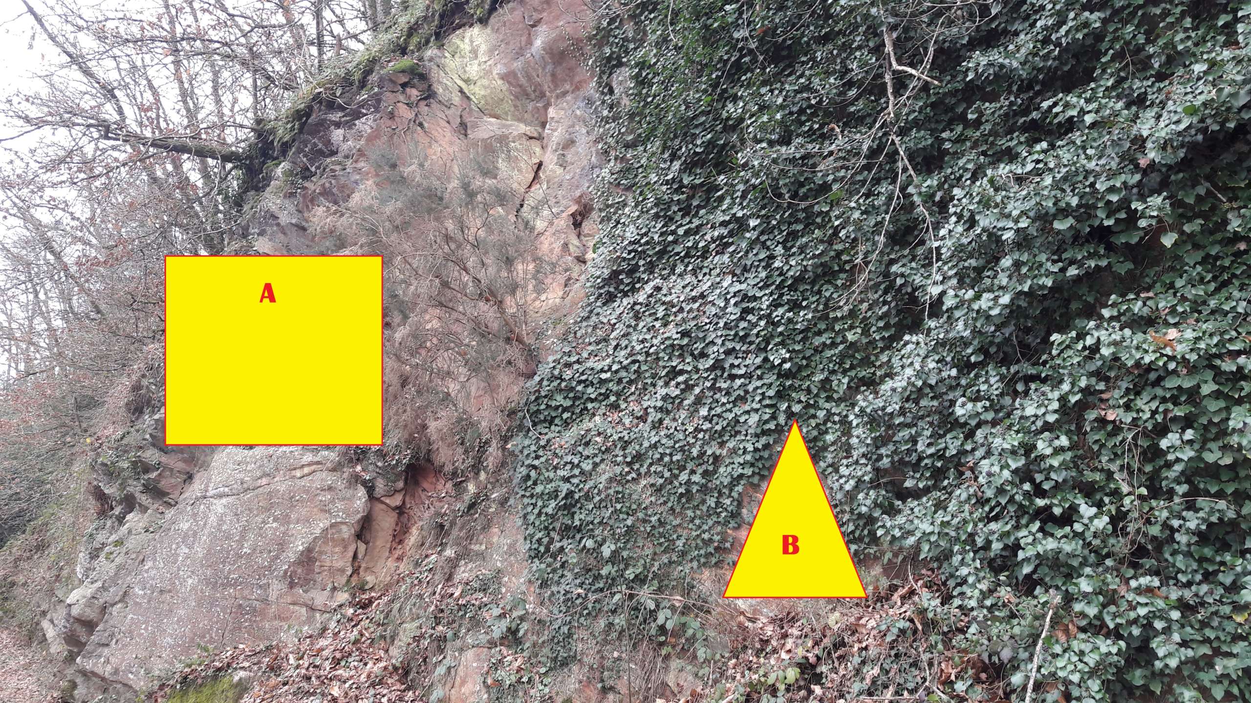
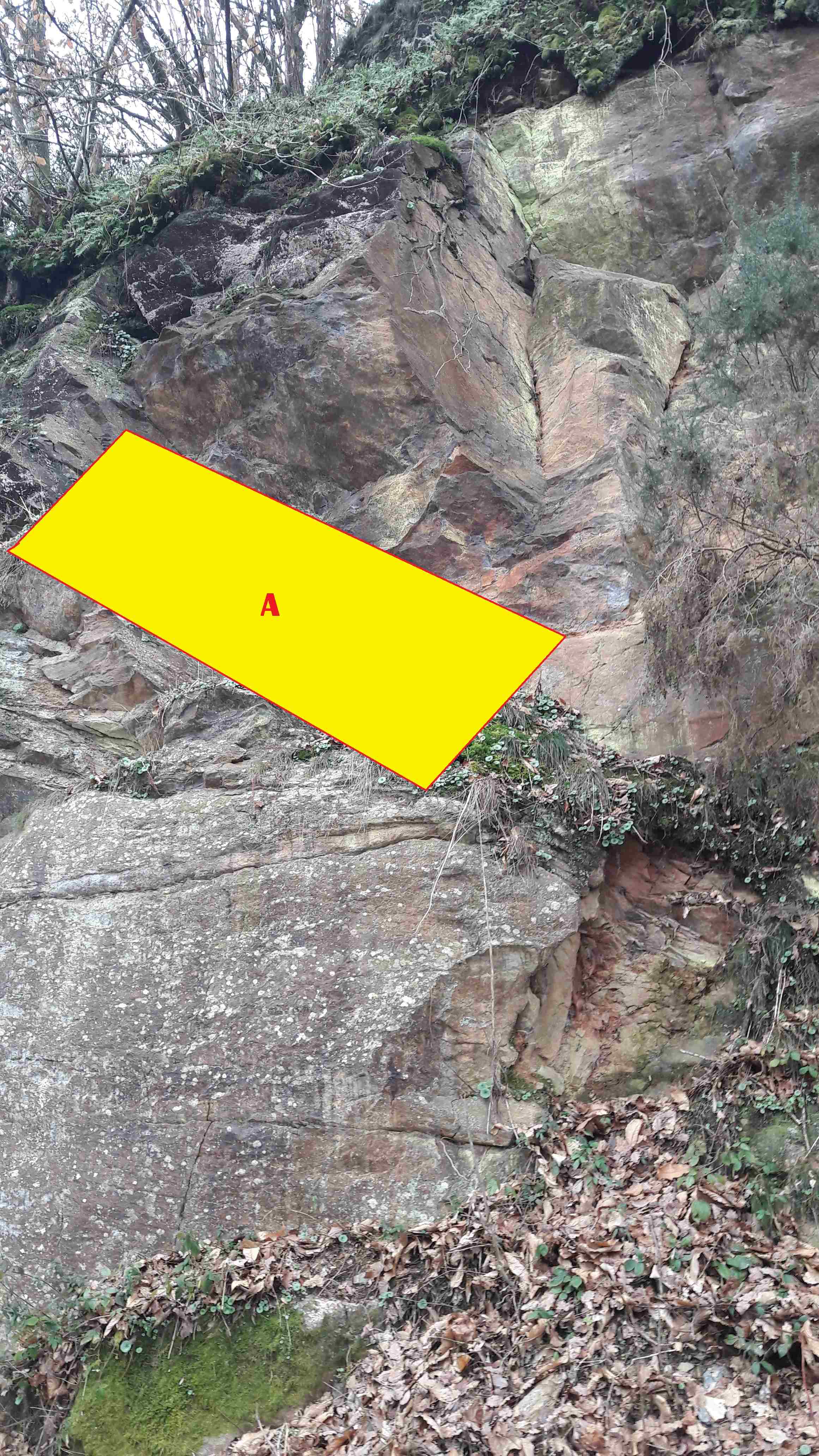
Q1 - Décrivez les caractéristiques de la zone A (couleur, taille des grains, présence d'une foliation, présence de vénules de quartz,...).
Q2 - De quelle roche roche s'agit-il? Est-ce cohérent d'en trouver ici?
Q3 - Quelle est la couleur prédominante de la zone B. A quoi est-elle due ?
Une photo du site, en noir et blanc, sera la bienvenue, bien que facultative.
To validate your visit to the site, send me, although specifying the name of the earthcache, your answers by e-mail (from my profile, or email [Message Center] from geocaching.com) the following questions . You can log "Found it," I will contact you if necessary:
Q1 - Describe the characteristics of zone A (color, grain size, presence of foliation, presence of quartz venae, ...).
Q2 - What rock is it? Is it consistent to find here?
Q3 - What is the predominant color of zone B. What is it?
A photo of the site, in black and white, will be welcome, although optional.
Rappel concernant les « Earthcaches »: Il n'y a pas de conteneur à rechercher ni de logbook à renseigner. Il suffit de se rendre sur les lieux, de bien lire le descriptif, d’observer et de comprendre pour pouvoir répondre aux questions ci-dessus. Loguez „Found it„ et, en même temps, envoyez nous vos propositions de réponses via notre profil, soit par mail, soit par la messagerie (message center). En cas de problème, nous vous contacterons. Merci de ne pas faire figurer de réponse dans vos logs !
Reminder concerning "Earthcaches" There is no container to search for information or logbook. Simply visit the site, to read the description, observe and understand in order to answer the questions above. Log in "Found it" and at the same time, send your answers via our profile proposals, either by email or by mail (Message Center). In case of problem, we will contact you. Thank you not to include response in your logs!