|
To complete this earthcache you will need to bring:
- Tape measure (at least 1.5m)
- Watch (something to count seconds)
- Notebook and pen to record your findings
- It will be easier if you are prepared to go wading
|
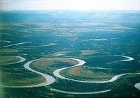
Grovetown Lagoon is an oxbow lake. That is it is a meander (loop) of the Wairau River that has became separated from the river, creating an independent lake. Let's have a look at how it was made.
To make an oxbow lake, start with a meander...
Water tends to travel downhill in a straight line, in a state known as laminar flow, which simply means a smooth, non-turbulent flow. However obstacles such as river plants, animals, rocks and debris upset that flow, deflecting the water so that a local patch of water runs at an angle to the general flow of the river. Sometimes a eddy current is made, where water flows in a circle, especially behind a larger obstacle. Where there is a reasonable slope to the land, these deflections have little effect on the overall direction of the river however, when the river reaches a wide plain with very little slope, these small currents can cause the river to change course, creating "meanders." Meanders become self sustaining.
When a river reaches a low-lying plain, often in its final course to the sea or a lake, it meanders widely. In the vicinity of a river bend, water flows faster on the concave bank (the bank on the outside of a bend), scouring out the bank wall with lateral erosion and undercutting, creating a small cliff. Similarly, the river bed under the cliff is scoured out, creating deep water. The material collected from this erosion action is deposited downstream onto the convex banks (the inside of the bend), where water speed is slower and consequently has less energy, creating shallow water and beach like structures called point bars. Continuous erosion of the concave bank and deposition on the convex bank of a meandering river cause the formation of a very pronounced meander with two concave banks progressively getting closer together.
Then cut through the neck.
When the narrow neck of land between the two neighbouring concave banks is finally cut through a new, straighter river channel develops — leaving an abandoned meander loop. When deposition finally seals off the loop from the river channel, an oxbow lake is formed. This process can occur over time from a few years to several decades, and may sometimes appear essentially static. Once the oxbow is isolated from the river, unless it has a stream or other source of water feeding it, it will silt up and evaporate, becoming a swamp and eventually disappear, leaving an oxbow scar - just a light depression in the ground where the lake once was.

All oxbow lakes are the result of a meander becoming disconnected from its river. There are three principal means by which this disconnection happens:
|
Meander convergence
If the erosion at the neck continues long enough the bends will simply join. Water will take the direct route and seal up the connection to the old meander. This creates a highly curved oxbow lake with its ends close together and converging.
|
 Nowitna River, Alaska
About to break through
|
Flood
Floods cause large amounts of water to enter the river course, often with debris. Meanders have the effect of slowing the water, causing flood waters to back up upstream. Should they breach the banks of the neck of a meander the fast flowing water may scour out the land, carving out a new water course across the neck of the meander. Most naturally occurring oxbows are formed this way - where the neck of a meander gets quite small, and a flood finishes the work.
Human intervention
The removal of meanders - straightening the river - is a common strategy for both flood prevention and improved navigation. A straighter river allows for higher water speeds so that high volumes of water can pass through an area quickly. The Mississippi River in the United States, for example, is shorter now than it was in the 19th century, because engineers have cut off hundreds of meanders. This created hundreds of oxbow lakes. These lakes eventually dried up to create land for farming, housing, and industry. Similarly, the Oxford Canal in England is a river course straightened primarily to improve navigation.
Grovetown Lagoon
Grovetown Lagoon may one day silt up and disappear, but this will take considerably longer than normal as, unlike most oxbow lakes, Grovetown Lagoon does have a supply of fresh water. These consist primarily of two drains and a freshwater spring. The drains remove surface water from the adjacent agricultural land and normally have no flowing water, except during and after rain, but the spring has a strong flow at all times of the year. The lake, however, does not have any natural exits. As you walk to the stream waypoint you will pass two pump houses, one at each end of the lake, that provide the outlet function. When the lake level gets too high they automatically switch on to pump excess water into the adjacent Wairau River.
Note: The lake area is undergoing restoration as a wetlands area, with significant native planting and weed and pest control. Do not handle any wooden boxes you may find - these are pest traps that have very strong springs and are quite capable of breaking your fingers.
The Earthcache
Copy-and-paste the questions below into a message to the cache owner. Make sure you identify which earthcache this is! Below each question add your answers. Please wait for the CO okay before logging your find.
At and near the published coordinates (or maybe online):
Q1. Identify which of the above three processes created the Grovetown Lagoon. When or how long ago did this happen?
Q2. What evidence in the landscape supports your answer to Q1? Also, what evidence is missing that you would expect to see for each of the rejected options? You effectively need three statements, one for each option, to adequately answer this question.
It might help to check out the nearby map and re-read the cache description.
At the spring waypoint:
Q3. What is the rate at which water from the spring enters the lake?
Anywhere around the lake:
Q4. (Optional) Please post a photo showing us the state of the lake at the time you visited.
To measure the rate at which water enters from the spring, you need to go to the stream waypoint. You can circle the entire lake if you wish, but getting there by walking anti-clockwise around the lake from the cache coordinates is the quickest route. Walk in front of the rowing club onto the stop bank. You will pass a gate - be a responsible kiwi and ensure you leave gates the way you find them. Follow the path beside the pumphouse to the stream. Find a point in the stream with a fairly even bottom then measure the width in metres (w), measure the depth in metres (d). Mark off a length in metres (l) and drop a stick or leaf into the fastest part of the current and time how long it takes to travel that length (s). Try to be accurate - it will be much easier to do this if you stand in the stream. The water is fresh and clean and the bottom of the stream is firm sand.
Speed of the water = w * d * l / s * 1000 litres per second.
Be sure to state any conditions that are present that may make your answer different from expected (eg recent heavy rain).