Introduction to the EarthCache
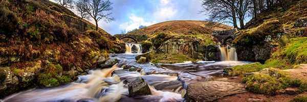
Three Shires Head is a popular beauty spot in the Peak District. It is the point where the counties of Derbyshire, Cheshire and Staffordshire meet and this boundary is exists here because two rivers meet at this point. It was reputed that illegal boxing matches used to be held at Three Shires Heads and when the police turned up the participants would simply cross over the stream into another county and thus escape arrest. There are two very different old bridges that cross the river here made by man as part of ancient silk trader packhorse routes, but it is nature that has sculpted the cascading waterfalls, the pools and created the scene we see today.
So how does a beauty spot like this come to exist? Well, it wasn't like this originally, it is geological processes over the years that have created the picturesque scene that is here today and this EarthCache looks at how and why this happened. This is an observational EarthCache. This means you only need to visit the listed location and observe the rocks. Any information required to answer the questions will be found in the listing, you do not need to complete any further research and the questions should be easily answerable when you are there.
I've made it a D3 because there are a few questions - but although there's a few, I've made the questions really easy by splitting everything down so many of the questions only need a couple of words to answer and all the information can be found in the listing. Sometimes it's easier to ask more questions with simpler answers than to ask less questions with more complicated answers so please give it a go, I'm sure you'll have no problems.
The easiest access to Three Shires Head is still along the old packhorse track from the parking although it can be incorporated into many different walks in this beautiful part of the Peak District. Although not directly accessible by motor vehicles you can get there on foot, bike or horseback from the parking waypoint which is 3/4 of a mile away.
Sedimentary Rocks
Three Shires Head is situated on Axe Edge, on the border of Derbyshire, Staffordshire and Cheshire. Axe Edge is made of sedimentary rocks. Sedimentary rocks are formed from particles of sand, shells, pebbles, and other fragments of material. Together, all these particles are called sediment. Gradually, the sediment accumulates in layers and over a long period of time hardens into rock. An example might be millions of years ago a flood caused a layer of sand to be deposited. Then maybe a few years or many years later another flood left another layer of sand. This process continued for millions of years, the lower layers gradually getting squeezed more and more by the heavy deposits above them.
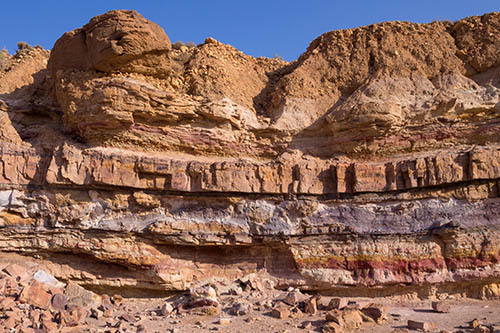
When you put enormous pressures on sand for a long time, the sand grains fuse together, forming sandstone. The process of turning loose material into rock is known as lithification. Often, sedimentary rock is fairly soft and may break apart or crumble easily however there can be some sedimentary rocks that are quite hard and Three Shires Head demonstrates both harder and softer varieties of sedimentary rocks. You can often see sand, pebbles, or stones in sedimentary rock, and it is usually the only type that contains fossils.
The Rocks of Axe Edge
Axe Edge consists of two types of rock - softer shale and harder millstone grit. The harder millstone grit was originally buried beneath the softer shale but in places it has now become exposed because the softer shale is more easily eroded where as the harder millstone grit is much more resistant to erosion. Let us take a look at the differences between these two rocks.
Shale
Shale is a specific type of mudrock. Mudrocks are a class of fine grained sedimentary rocks. The varying types of mudrocks include: siltstone, claystone, mudstone, and shale. Most of the particles of which the stone is composed are less than 0.0625 mm (1/16th mm or 0.0025 inches) and are too small to study readily in the field.
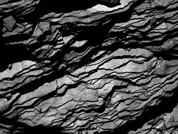
Shale is a fine-grained, sedimentary rock composed of mud that is a mix of flakes of clay minerals and tiny fragments (silt-sized particles) of other minerals, especially quartz and calcite. The ratio of clay to other minerals is variable. With increased pressure over time, the clay minerals may become aligned, with the appearance of fissility or parallel layering. This finely bedded material splits readily into thin layers and is called shale, and this is the distinction from mudstone.
Shale is characterized by breaks along thin laminae or parallel layering or bedding less than one centimeter in thickness, called fissility. Fissility refers to the property of a rock which allows it to be split along planes of weakness into thin sheets. Other types of mudstones are similar in composition but do not clearly show the layers, and could not be broken into thin sheets.
Millstone Grit
Millstone Grit is a catchall name for a variety of coarse sandstones, referred to here as "grits". Grits were laid down in the delta of an immense river which flowed from a mountainous area. The land was below the sea, and every tide, every flood, dumped sand onto the sea floor. Generally the layers were thin and/or disturbed by currents. Occasionally some event would occur which laid down layers many metres thick in a very short time. All this happened around 300 million years ago, long before the dinosaurs. Eventually the grits were buried by the shale. The layers of sand, under pressure and subject to chemical change, became rock. Eventually what is now England was pushed up out of the sea and erosion began.
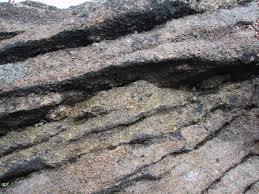
Some layers of gritstone were often laid down in ways which have left uniform rock, free of lines of weakness. They outcrop on famous rock climbing Edges such as the Roaches which are not so far away in Staffordshire. Rocks free of natural lines of weakness are a kind of "freestone" to a mason - a material which can be worked in any direction. These are the layers worked for centuries to produce querns and millstones to grind cereals such as wheat and barley. Grit continues to be quarried for building stone and many examples can be seen in the local area, including stone used in the bridges here at Three Shires Head.
Formation of a V-shaped valley
At Three Shires Head, not only do two streams meet to become one, but in addition two valleys meet and become one larger valley. Valleys are classified as either U shaped, V shaped or flat floored depending on how they are formed and you may well have done other EarthCaches relating to the identification of the valley type. On this occasion the valley is a v-shaped valley and you should be able to spot evidence when you visit to explain why we know this is the case.

A V-shaped valley, sometimes called a river valley, is a narrow valley with steeply sloped sides that appear similar to the letter "V" from a cross-section. V shaped valleys are formed by the flow of water. In a hilly area such as here at Three Shires Head, water falls onto the hills and as it drains downwards with gravity the water forms small channels in soil. Eventually, the water channels combine to become strong streams, which over time cut down into the rock through a process called downcutting. These valleys form in mountainous and/or highland areas with streams in their "youthful" stage. At this stage, streams flow rapidly down steep slopes. An famous example of a V-shaped valley is the Grand Canyon in the Southwestern United States. After millions of years of erosion, the Colorado River cut through rock of the Colorado Plateau and formed a steep sided canyon V-shaped canyon known today as the Grand Canyon.
Where the rocks forming the hills are weaker (rocks such as mudrocks) the streams will find it relatively easy to erode the rock. The sediment the rocks were originally formed from gradually gets washed away and the channel gets deeper in the hillside. Where the hill is formed from different types of rock, eventually the water may hit a harder stone that lies beneath the softer rock and this hard rock may not be so easily eroded and this rock will become exposed and small cascades or waterfalls may be created.
Questions to Answer (Logging Requirements)
There is no physical box here, in order to log a find on an EarthCache you must answer the questions below and send them to me via my profile (either email or message centre). I do read all answers and try to reply to them all - however if I'm busy I may not be able to reply immediately so please do not wait for a reply before posting your find. You are not expected to have any previous geological knowledge, your best attempt at the answers is all that is required. Ideally, please send your answers at the same time you submit your log, or within a few days of your visit. If you do not send answers, your log may be deleted. The questions are in two parts - valleys and rocks.
Firstly, let's answer some questions about the valley.
V1) Let's begin by looking at the valleys here. What type of valley is it and how has it formed?
V2) Imagine you were stood here, in exactly this spot, all that time ago when England had not long since been pushed out of the sea and Axe Edge had only just been created. If you were stood exactly where you are today what would be here - how would it be different to today?
V3) Geologically speaking, why do you think the builders of the old packhorse road decided to build their packhorse trail at this particular height in the valley and build their bridges at this particular point?
Secondly, we will turn our attention to the different rocks.
R1) Find an exposed area of the rock that is prominently exposed in either the cliffs, waterfalls or bedrock of the stream that has been recently in contact with the water. This means it will be fresh and unpolluted. Describe the texture, colour, hardness and any other notable features of the rock.
R2) Above there are descriptions of two types of rock - shale and millstone grit. What type of rock is prominently exposed in the cliffs, waterfalls and bedrock of the streams between the bridges and the meeting point of the two rivers? Your answer to R1 should help.
R3) The rock here appears to form shelves - these are individual layers of rock formed due to sedimentary processes. What is the height of the biggest one and where did you spot it? Why are some layers thicker than others?
R4) Explain (briefly) why this rock has become exposed in this particular place? Considering the hardness of the two rock types, how well do you think it is resisting erosion from the water compared to the other type of rock the hill is formed from? How has the water flowing down the valley over the years created the beautiful scene you see here today?
R5) Panniers Pool lies beneath the packhorse bridge and is a popular place for wild swimming as it can be up to 7ft deep depending on the water flow. Given what you've learned about the rock here, explain why this particular pool might have become so deep when other pools have not? You are not required to swim in it to answer the question but extra marks if you do! The consensus suggests it's usually quite chilly!
R6) You have named one type of rock in question R1, but we know the other rock must be here somewhere as it features greatly in Axe Edge. Can you spot any - if so where did you see it? Why is the rock type in question R1 so exposed when this type of rock much harder to observe?
Please feel free to include photographs of you and/or your GPS device at Three Shires Head - this also provides additional proof of your visit but is optional and not a logging requirement.
Please note, you may well not have phone signal here. Whilst this EarthCache has been designed so you can send the answers from GZ, be aware at the time of publication, if you use the message center via the official app, it does not queue messages to be sent when you have signal as it does it logs, it simply deletes them if there's no signal. Therefore please consider sending an email via my profile if you have any doubt over the signal.
Thank you for visiting the Three Shires Head EarthCache