Rosario Head, A Tale of Two Terranes 💥 EarthCache
Rosario Head, A Tale of Two Terranes 💥
-
Difficulty:
-

-
Terrain:
-

Size:  (other)
Please note Use of geocaching.com services is subject to the terms and conditions
in our disclaimer.
For purposes of logging this cache you must answer the following three questions:
1) At the posted coordinates locate the pillow basalt. Describe their shape, color, and texture. Do they have gas bubbles or polka dots? What does this tell you about its environment of formation?
2) Proceed to waypoint 1. This guy is a long way from home, purportedly Alaska! How does this rock seem different than its neighbors?
3) Carefully proceed to WP2. Follow the trail down the hill until you come to an intersection. Go left or west until you get to wp3 and locate the ribbon chert. Describe their shape, color, texture and direction of pattern.

 An earthcache is the magical combination of geocaching and geological discovery. They vary greatly from traditional geocaches in that there is NO PHYSICAL CONTAINER! Once at the Earth Cache site, take in the scenery, the geological marvels or oddities, and read the cache description. You will likely be asked to answer some questions about the site and optionally take a picture. You can email the cache owner or use the Message Center to send answers to the required questions. Please don’t be intimidated about answering the questions. They are not graded and were meant to enrich your visit, open your eyes and provide you with new knowledge and insights about the location. Most importantly have fun!
This earthcache is located at Deception Pass State Park and placed with permission and a permit.
This is a tale of two terranes! Like the pole you’ll encounter on your walk, the land narrates a story. The rocks here bear witness to a long, complex, and tortuous course of geologic evolution. This faulted, folded, sheared and generally disheveled collection of rocks tells a quite remarkable tale of island evolution, accretion, rift tectonics and terrane abduction, as well as more recent events which have molded their modern appearance. These rocks are crystal balls on an exotic and remarkable past.
Folds, faults, and other geologic structures accommodate large forces such as the stress of tectonic plates jostling against each other, and smaller forces such as the stress of gravity pulling on a steep mountainside. An understanding of the structures that shape the earth’s crust can help you see when and where the crust was subjected to pushing or pulling, terrane accretion or crustal rifting.
Faults
A fault is a planar surface within the earth, along which rocks have broken and slid. Faults are caused by elastic strain that culminates in brittle failure. The rocks on either side of a fault have shifted in opposite directions, called the offset directions. If a fault is not vertical, there are rocks above the fault and rocks beneath the fault.
Not every crack in the ground is a fault. What defines a fault is the movement of the rock on either side. When that movement is sudden, the released energy causes an earthquake. Some faults are tiny, but others are part of great fault systems along which rocks have slid past each other for hundreds of miles.
Large faults within the Earth’s crust result from the action of plate tectonic forces, with the largest forming the boundaries between the plates, such as subduction zones or transform faults. Energy release associated with rapid movement on active faults is the cause of most earthquakes.
Folds
Ductile rocks behave plastically and become folded in response to stress. (When rocks bend or flow, like clay, it is called ductile deformation.) Even in the shallow crust where rocks are cool and relatively brittle, folding can occur if the stress is slow and steady and gives the rock enough time to gradually bend. If the stress is applied too quickly, rocks in the shallow crust will behave as brittle solids and break. Deeper in the crust, where the rocks are more ductile, folding happens more readily, even when the stress and strain occurs rapidly.
Anticlines and Synclines
The most basic types of folds are anticlines and synclines. 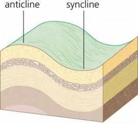 Imagine a rug, the sides of which have been pushed toward each other forming ridges and valleys – the ridges are “up” folds and the valleys are “down” folds. In terms of geologic structures, the up folds are called anticlines and the down folds are called synclines. Synclines can be as small as the side of a cliff or as large as an entire valley. Anticlines can be as small as a hill or as large as a mountain range. You're looking at an anticline, actually, when you view Rosario Head. Think of it as the crest of a land wave: synclines are the troughs. The land around the Pacific Northwest is wavier than the ocean.
About the hike:
From parking the walk is only .5 mile round trip with a very small amount of elevation gain. Take the loop trail clockwise or left around Rosario Head, but be careful of the steep drop off along the cliffs. Keep children and dogs away from the edges. Along the beach you will have crossed the terrane boundary between Decatur and Lopez terranes. You’ll start and end your journey on the Decatur Terrane. Rosario head is a knob of the Lopez Terrane. Faults and folds have sliced, diced and twisted these rocks into a remarkable jumble.
Make your way to the posted coordinates. 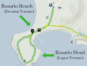 Pillow basalt is exposed here. The pillow basalt was formed as magma was extruded into the ocean at a spreading center where two oceanic tectonic plates were moving apart. Some pieces of basalt may look like they have “polka dots.” The white dots on the rock are minerals that filled in the gas bubbles in the lava. Pillow basalt with polka dots erupted at a shallower depth. In very deep water, such as at a seafloor spreading center, the weight of the water squeezes out the gas in the lava, and the basalt that forms has no vesicles (gas bubble holes). Do the pillow basalt located here have gas bubble holes or polka dots? What does this tell you about its environment of formation?
Now make your way over to WP1. Here you will find a large erratic. An erratic is a rock or boulder that differs from the surrounding rock and is believed to have been brought from a distance by glacial action. (In this case all the way from Alaska!)
Carefully proceed to WP2. Follow the trail down the hill until you come to an intersection. Go left or west until you get to wp2. If you want to get an idea of the power of the forces at a plate boundary, note how contorted these rocks are! They’re ribbon chert, formed in a deep ocean environment from the exoskeletons of a sea plankton radiolarian. For ages, they lived their lives and died their deaths, drifting silently down to the seafloor, where time and pressure turned them to stone. To put together the history of the area, geologists analyzed microscopic fossils from the chert. The fossils are species of radiolaria (or radiolarians, one-celled organisms that had mineral exoskeletons and lived in shallow ocean water).
The next logical question is, "How were these deep ocean rocks transported onto the continent and exposed at sea level at Rosario Head?" Essentially these rocks were scraped onto the North American continental plate as the Juan de Fuca/Farallon oceanic plate was subducted beneath it.
EDUCATIONAL LOGGING REQUIREMENTS
In order to substantiate your visit and comply with the educational requirement for Earth Caches you have to submit your answers to the following questions to the cache developers via their profile:
For purposes of logging this cache you must answer the following three questions:
1) At the posted coordinates locate the pillow basalt. Describe their shape, color, and texture. Do they have gas bubbles or polka dots? What does this tell you about its environment of formation?
2) Proceed to waypoint 1. This guy is a long way from home, purportedly Alaska! How does this rock seem different than its neighbors?
3) Carefully make your way to WP2 and locate the ribbon chert. Don't go straight over to it. Follow the trail down until the intersection. Then go left or west to the coordinates. Describe their shape, color, texture and direction of pattern.
4) On your hike around the head did you observe more faults or folds? Based on what you learned about faults and folds what does that tell you about Rosario Head's rock makeup or background?
|
Links
Coastal Care
The Coast Nerd Gazette
Fidalgo Island Crossings
Tidal Life
Reading the Washington Landscape
Northwest Geology Field Trips

|
- This geocache has an approved Permit to be placed at this location on property managed by the Washington State Parks and Recreation Commission. Visitors are responsible for acquainting themselves with policies and rules pertaining to State Parks areas.
- The following items may not be placed in the geocache: food, illegal substances, medications, personal hygiene products, pornographic materials, hazardous materials, or weapons of any type.
- By searching for the cache, visitors agree that they are responsible for their own actions, and acknowledge that neither the State of Washington nor the cache owner is responsible for any loss or injury that may occur in relation to such search.
- Report any incident, problem, or violation to State Parks staff.
|
Additional Hints
(Decrypt)
Qba'g sbetrg gb ohl naq/be qvfcynl lbhe cnex cnff! Or pnershy nf lbh cebprrq gb JC2! Qba'g tb fgenvtug bire gb vg. Sbyybj gur genvy qbja hagvy gur vagrefrpgvba. Gura tb yrsg be jrfg gb gur pbbeqvangrf.