Basalts and Breccias at St Edmund's:
At the headline coordinates we will be studying two rocks from an interesting period of earth's history: the Permian. Characterised by a locally hot dry environment with temperatures on average several degrees above today's mean, this time period resulted in the deposition of large volumes of red sandstones, conglomerates and breccias that produce Devon's classic red soils and hills. These can be seen clearly via natural exposure at the coastline from Torbay to Exmouth and at engineered road cuttings in the Exeter area. Both rocks have been extensively used as building stones in the wider area since at least the medieval period and can be seen in many of Exeter's historic buildings.
Ruins of St Edmund's Chapel:

St Edmund's is now nothing more than a ruin but was once one of three chapels that stood on the medieval Exe Bridge; only 8 arches of the bridge survive from an original 18 or so that would have spanned the river Exe and would have appeared very different from what stands here today. As the only local crossing point, it would have seen significant traffic over its near 800 year history. The chapel stood at the eastern end of the bridge and outside the city's west gate; it was built parallel with the bridge across two of the bridge's arches. The fabric of the church was supported underneath by stone pillars to allow water to pass underneath the church and through the spans of the bridge. Finally demolished in 1973, all that remains now is part of the bell tower.
Exeter basalts and breccias:
Basalt: a fine-grained igneous rock of volcanic origin. Basalt is formed from the relatively rapid cooling of low Silica (SiO2) and high temperature (around 1000-1200c) lavas erupted from volanic fissures and vents. Basalt can be deposited in sheets at the surface or dikes and sills at shallow depths.
Basalt flow above vesicular rubble:
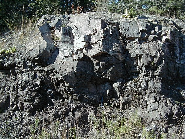
The Exeter series of Basalts has been classified as olivine-basalt, olivine-trachyte, ciminite or trachybasalt depending on which paper from 1902 (Teall), 1932 (Tidmarsh) or 1969 (Knill) you believe. None of this is important, however, as most rocks defy our attempts to pigeonhole them. What is clear is that this particular rock has been quarried in the Exeter area for at least several hundred years; one of these quarries can be found near Pocombe but now plays host to a private storage area so I wouldn't recommend going there. It can appear in several forms; massive (uniform texture), vesicular (bubbly) and veined (typically a white dolomitic carbonate).
The basalt lavas of the Exeter area would have flowed some time in the Permian period between 290-250 million years ago when the area was somewhere near the equator in the supercontinent of Pangaea but since that time have experienced significant chemical alteration and intrusions of hot mineral rich fluids from subsequent volcanic events.
Breccia: a sedimentary rock consisting of unrounded angular fragments of other rocks bound together by small particles of sand or clay and chemically cemented together. The angular nature of the fragments (clasts) suggests that they would not have travelled far from their original source.
A typical arid desert environment prone to deposition by flooding:

The Exeter Breccias form part of the Teignmouth Breccia series but can be further classified as Alphington and Heavitree Breccia. Our interest is in the Heavitree Breccia, though, as its well-cemented matrix means it has been extensively quarried as a local building stone. Generally it consists of a fine grained red mass with dissimilar fragments of less than 8cm size (and frequently much smaller).
It was deposited in a dominantly dry semi-arid region with periodic sheet flooding from heavy rainstorms that would have transported rock fragments from nearby hills and mountains and spread muddy and sandy gravel fairly evenly over the area repeatedly for several million years in the Permian Period between 290-250 million years ago. This resulted in beds of up to 300m thick and one such exposure can be clearly seen at the M5 motorway cutting just east of Exeter.
At the headline coordinates:
1. Examine the irregularly shaped blocks of basalt that have been used to pave the surface of the arched bridge. Describe their appearance (colour, texture, etc)
2. Do all the basalt blocks appear to be all the same or do they differ in appearance?
3. Examine the basalt blocks used to construct the exterior wall of the chapel. The best examples are just to the right of the obvious arched doorway. Describe their appearance. Do they appear the same as the paved surface or do they differ? If so, why do you think this is?
4. Examine they breccia blocks that were used to construct the interior walls. Describe the appearance of the fragments that make up the breccia.
5. From your examination of the area, what can you conclude about the relative ages of the basalts and breccias?
Answers can be sent by message or email; you do not need to wait for a personal response to log a find but please ensure to send your answers or your log may be deleted.