Rehabilitation Of Pits and Quarries
"Aggregate extraction is an interim land use. Once aggregate is extracted from a pit or quarry, the site is rehabilitated into productive wildlife habitats, wetlands, golf courses, recreational parks, urban uses, conservation lands, forestry or agricultural lands.”
(OSSGA) Ontario Sand and Gravel Association
What is Rehabilitation?
Rehabilitation of a pit or quarry involves the management of all of the property's natural resources during the aggregate extraction process.
Topsoil, including the seed sources that it contains, and overburden are managed carefully (i.e. stripped and placed separately in a manner that reflects the original profile) throughout the life of the operation to ensure that they can be used to progressively create a new landscape and land use for the pit or quarry.
Rehabilitation sequences are carefully planned during the preliminary licensing process, and become a legal requirement when the site is first
licensed. As the aggregate extraction progresses through the site, the topsoil and overburden are sequentially replaced to ensure that the property is properly prepared for its future land use.
Rehabilitation activities commonly include wildlife habitat restoration and forestry management activities, proper soil enhancement to ensure agricultural productivity, landform creation to support recreational activities, and many other state of the art techniques designed to ensure the next land use for the property is productive and sensitive to local land use patterns.
Progressive Rehabilitation
Aggregate producers must perform progressive rehabilitation as they extract their sites. Progressive rehabilitation means rehabilitation done sequentially within a reasonable time after extraction of aggregate resources is complete.
As one area of their pit or quarry is being extracted, rehabilitation must be completed in the areas where the aggregate reserves have been exhausted. Progressive rehabilitation is beneficial in many ways as it:
Reduces the open areas within a pit or quarry
Reduces soil erosion potential
Reduces double-handling of soil materials
After Uses
There are many good examples in Ontario of after uses. These include:
- Agriculture
- Tender fruit production and grape vineyards
- Naturalization and wildlife habitat Wetlands, floodplain habitat development
- Golf courses
- Recreational parks and lakes, trails and conservation lands
- Forestry
- Urban uses
Factors to consider when selecting an appropriate after use:
- Surrounding land uses (present and future)
Surrounding ecological/natural heritage systems
Stakeholder input (neighbours, municipalities, special interest groups, partners)
- Method of extraction (depth, proximity to water table)
- Available resources (topsoil, overburden, seed bank, transplanting opportunities)
- Geology of the deposit
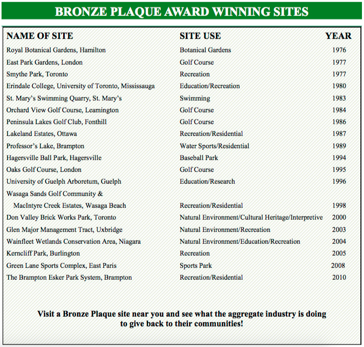
Bronze Plaque Award
“The Bronze Plaque Award was established in 1975 as the most prestigious industry award presented by the Ontario Stone, Sand & Gravel Association . . . It is reserved for sites that have become truly outstanding examples of the state-of-the-art in pit or quarry rehabilitation.”
(OSSGA) Ontario Sand and Gravel Association
Bronze Plaque Award winning sites such as the Royal Botanical Gardens in Hamilton, Erindale College (University of Toronto) in Mississauga, the University of Guelph Arboretum in Guelph, and the Don Valley Brick Works Park in Toronto are all excellent educational resources to their host communities.
These rehabilitated pits and quarries provide opportunities for wildlife habitat, passive recreation, geological interpretation, botanical research and show- case important cultural heritage features.
Logging Requirements
To Log this EarthCache, you must submit your answers, to the following Questions, to the CO at the top of the page.
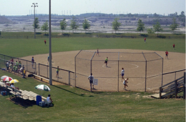
1) The posted coordinates will bring you to an extensive view of a quarry in transition. In the distance, the quarry is in full operation, but you will be standing in a part of the quarry that has been rehabilitated. Please provided % estimates for the current uses of the quarry you see in front of you.
a) Operating quarry,
b) ball park area,
c) re-naturalized area
2) From the Parking lot,
a) to the baseball diamond, estimate (or measure) the difference in elevation,
b) then estimate the difference in elevation from the parking lot and the base of the current quarry (depth of quarry)
3) From the list of after uses, in the cache description, draw a sketch of the quarry from where you are, showing both the rehabilitation area, as well as the area still be used for aggregate excavation, be sure to identify all the after uses on your sketch.
Optional
4) We are looking for a photo here, of your GPS, thumbs up or of yourself (if you wish), with the Bronze Plaque Award in the background.
References:
https://www.ossga.com/multimedia/9/rehabilitation2010.pdf
https://www.ossga.com/multimedia/9/bronze_plaque_award2010.pdf