On the side of a busy road, closely near the Elephant and Castle roundabout there's a small yard that is not often spotted by many passengers. While not having a lot of distinguishable features from other small parks and green areas in the hugely populated city, it has a long hidden history that is waiting to be acknowledged.
The History
The history of the church officially starts in the fourteenth century when it is mentioned in a medieval document, but it may be a lot older as there is a church mentioned in the Doomsday Book that may or may not refer to the site of St. Mary’s. The lands around it had belonged to the Manor of Walworth, but the area changed its name to Newington, possibly because of the new houses, or ‘New Town’ that had sprung up on the edge of Walworth. According to John Noorthouck, it “is thought to receive the addition of Butts from the exercise of shooting at butts formerly practised here, and in other parts of the kingdom, to train the young men to archery”, although he does concede that it perhaps derived from the Butts family of Norfolk who had an estate in the area.
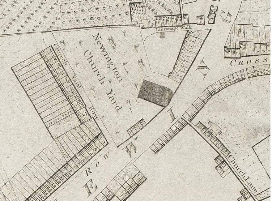
According to John Stow, in 1715 the church showed “a sudden rupture in the wall, which put the Congregation, then assembled, into such a general consternation that they all ran out, and many in making their escape, were bruised and trodden under foot, and received great hurt”. An investigation was launched and the structure was found “so much decayed in the pillars, walls and beams, and in the roof and foundation” that it was deemed unsafe and not worth the money repairing. The main part of the church was demolished in 1720, leaving just the clock tower standing. A new church, incorporating the old clock tower, was speedily built and opened in March 1721 and enlarged in 1793.
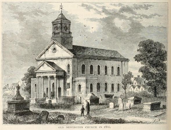
The Newington Butts Road became busier and busier and as the church stood so close to the road, it was considered a public danger. In 1876, the church was demolished and a new one built in Kennington Park Road. The old churchyard became a public garden and a year later, on the site of the old church, a new clock tower was erected which is described by Edward Walford:
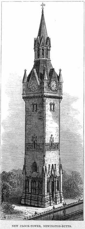 "This tower is fourteen feet square at the base, and carried up in five stages with buttresses to a height of about a hundred feet. The clock-face is placed at the height of seventy feet. In the lower part of the building the material is Portland stone, the remainder being of Bath stone, and the front to Newington Butts, as well as the two sides, is enriched with carvings in florid Gothic. There is a doorway in the centre of the front, with windows in the upper part. On the left side of the doorway is the following inscription: This tower was built at the expense of Robert Faulconer, Esq., Anno Domini 1877, on the site of the old parish church of St. Mary’s, Newington."
A newspaper report elaborated on Walford’s last remark. According to the Illustrated London News, the new tower had “at the sides of the doorway two handsome panels, filled with polished red granite, on which is the following inscription in engraved and gilded letters: – ‘This clock tower, erected A.D. 1877 by R.S. Faulconer, Esq. formerly a churchwarden of the parish of St. Mary, Newington, probably marks the site of the Saxon church mentioned in the Doomsday Book in connection with Walworth, as it certainly does that of several churches which have been built in succession upon it. The last church upon this site was erected in 1793, and was removed under the authority of an Act of Parliament in 1876, in which year on May 1, the new mother church of St. Mary, Newington, in the Kennington Park-road, was consecrated'”.
The Task
In order to get the final coordinates, gather information bellow from the information stand about St. Mary's Churchyard and from the surroundings in the area.
Stage 1
A - What year was the Domesday Book written?
B - What year was the rupture spotted according to the board?
C - What year the church had to be moved to the south?
D - What year the churchyard has been relandscaped?
E - What year was Michael Faraday baptised in St. Mary's Church?
F - What year Robert Rogers created Rogers' Rangers unit?
Stage 2
X - How many stones have black hemisphere on the top?
Y - How many stones have white hemisphere on the top?
Final location
N 51° Num1.Num2'
W 000° Num3.Num4'
Num1 = F-B-Y-1
Num2 = (2*D-A-E-25)/2
Num3 = (D-C+13)/(X+Y)
Num4 = C-F+X-2