|
Welcome to Zanzibar. Zanzibar is an island of coral origin. It forms coral limestone. Today we look at the eastern coast of the island, where this limestone created a small island that is subject to erosion and a spectacular spectacle. Welcome to the next sequel of the Geocache AGT series.
GEOLOGY ISLAND
The Zanzibar archipelago, consisting of the islands of Unguja and Pemba and several surrounding islets, arepart of the ancient Miocene Rufiji/Ruvu delta. The coreof these islands consists of rocks ranging in age fromMiocene to recent clacareous sediment with limestone of marine origin that was subsequently more or lesscovered by sands, silt and clays brought by rivers fromthe East African mainland. The abundance of corallimestones on both islands is thought to indicate thepossibility that the sea might have covered much of theislands at some point in time. However, due to periods of isostatic movement and block faulting over the coastalTanzania and offshore zone these islands remainedabove sea level as blocks of the original delta.
The islands are about 40 km from the coast of EastAfrica separated by Pemba Channel on the north andZanzibar Channel on the south. Unguja Island is about 40 km south east of Pemba and about 56 km north of Latham Island or Fungu Kizimkazi, which is a small un-inhabited island also part of the Zanzibar archipelago.
Pemba Channel is much deeper and can reach up to 800m in depth off the continental shelf of the mainlandTanzania.Pemba is a simple fault block and rose earlier thanUnguja; it is thus composed of lower stratigraphic rocks,and geologically much older than Unguja.Topographically, it is a single ridge and watershed with araised east coast. It is dissected by hills and ridges andhas a marked indented western coastline with low-lyingshore and numerous marine inlets and dense mangroveforests. The highest point on Pemba Island is atSiniongoni about 90m above sea level.
Unguja Island is elongate and indented only sparselywith a stand of mangrove forests much smallercompared to that of Pemba. Believed to have emergedfrom the sea later compared to Pemba, it wasconnected to the mainland of Tanzania as late as duringthe beginning of the Pleistocene age. The topography of Unguja Island is generally flat but with a central ridgerunning from north to south whose highest point is atMasingini about 120m above sea level.
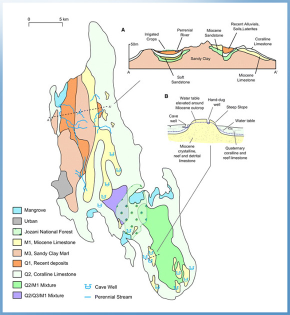
M1
Crystalline, reef and detrital limestone
Hard and dense crystalline Miocene limestone consisting of broken limestone, crushed coal,shell fragments and bands of flint. Sandy and gritty, formed as discontinuous reef, cavernousin places. Supplies water to lakes at Bambi and many springs and well, including cave wells
M3
Marls, sandy clays and clayey sands
Forms the main base rock of Unguja. Bluish grey to bluish green in colour comprising ofdense, roughly sorted Miocene chalky rocks with veins of gravel which weather to a red,yellow, or brown colour.
Q1
Soils, laterites, alluvial and colluvialdeposits
Mixture of red, brown and black Quaternary soils rich in iron oxide typical of tropicalenvironments. This fine grained soil maintains a water table forming an underground aquiferwhich provides a source of water for hillside springs.
Q2
Coralline and reef limestone
White, cream or yellow-brown Quaternary limestone which tends to be grey along rocky andjagged outcrops. Notably free from iron staining. Common across Unguja, except thenorth-eastern region, forming the island’s main underground aquifer. Frequently cavernousforming many cave wells in conjunction with M1.
Q3 Marine and fluvial sands and sandstone
Sands mixed with shell fragments, fish bones and sharks’teeth which are lightly cementedforming grey, coarse Quaternary sandstone. Provides water for pumped wells at KisimaMchanga and Cheju.
Doline
Bowl-shaped depression
Bowl-shaped closed depressions (1–1,000 m in diameter) formed by the dissolution oflimestone rocks by corrosive groundwater (carbonic acid from the reaction of water withcalcium carbonate which is abundant in limestone rocks). Fine-grained soils often drain intothese features.
Infiltration
The rate at which a soil or rock is ableto absorb water
Low infiltrating soils on Unguja are relatively fine grained, well-weathered soils typical of the Q1 geology type. Rainwater and irrigation will absorb relatively slowly into the soil helping tokeep soils saturated and retain water at the surface. Conversely, the Q2 rock type ischaracterised by high infiltration due to cracks and crevasses.
Regolith
Fine-grained weathered material
Loose, fine-grained material formed by weathering of rocks.
Terra rossa
Red clay soil
Red clay soil produced by the weathering of limestone.
Perennialstream
A river channel that runs continuouslythroughout the year
Limestone
Limestone is a carbonate sedimentary rock that is often composed of the skeletal fragments of marine organisms such as coral, foraminifera, and molluscs. Its major materials are the minerals calcite and aragonite, which are different crystal forms of calcium carbonate (CaCO3). A closely related rock is dolostone, which contains a high percentage of the mineral dolomite, CaMg(CO3)2. In fact, in old USGS publications, dolostone was referred to as magnesian limestone, a term now reserved for magnesium-deficient dolostones or magnesium-rich limestones.
About 10% of sedimentary rocks are limestones. The solubility of limestone in water and weak acid solutions leads to karst landscapes, in which water erodes the limestone over thousands to millions of years. Most cave systems are through limestone bedrock.
Limestone has numerous uses: as a building material, an essential component of concrete (Portland cement), as aggregate for the base of roads, as white pigment or filler in products such as toothpaste or paints, as a chemical feedstock for the production of lime, as a soil conditioner, or as a popular decorative addition to rock gardens.
|
|
A coral reef is a sea structure made out of living organisms which together form a wall.
Stony corals are usually the main organism found in a coral reef, but other types of skeletal material also join together to form the thick walls.
A coral reef is also "constructed" by the thousands of fish, sponges, and sea urchins grazing around the area. As these organisms move about, they actually help the coral reef settle and gain a more stable structure. Waves are also partly responsible for the size and format of a coral reef, as they affect the geology of the formation.
Coral reefs
Coral reefs begin to form when free-swimming coral larvae (planulae) attach to the submerged edges of islands or continents.
A fringing reef is one of the three main types of coral reefs recognized by most coral reef scientists. It is distinguished from the other two main types (barrier reefs and atolls) in that it has either an entirely shallow backreef zone (lagoon) or none at all. If a fringing reef grows directly from the shoreline, the reef flat extends right to the beach and there is no backreef.
There are two main components that make up a fringing reef, the reef flat and the reef slope.
Reef flat
The reef flat is the shoreward, flat, broadest area of the reef. The reef flat is found in fairly shallow water, and can be uncovered during low tide. This area of the reef is only slightly sloped towards the open ocean.
Since the reef flat is adjacent or nearly adjacent to land, it sustains the most damage from runoff and sediments. Typically, few of the flat's corals are alive. Seagrasses, seaweeds, and soft corals are often found there.
|
|