To log this EarthCache, you will need to visit the physical location and answer questions in relation to geology. You will then need to send your answers to me via the Message Centre. You are welcome to log the cache before you send the answers, however answers not sent within 1 week will result in your log being deleted.
Welcome to the Surf Coast - home to some of the most stunning beaches and coastlines in the world! This earth cache will give you a lesson in the geology of the Torquay Coastline, speficially some of it's stunning caves! This earth cache is tide dependent. At high tide the posted coordinates and WP1 are likely to be hard to get to. Currents could push you against cliff faces and also smash you against rocks beneath the water. However, at low tide it is a quick walk to the posted coordinates and a little wading to WP1. A TAPE MEASURE is also required to complete this cache.
The Torquay Cliffs:
At the posted coordinates you will be standing at a rock formation in front of a cliff. Look up towards the cliffs around you. The pigments in the cliffs of Torquay are the result of breakdown and movement of unstable iron oxide (commonly known as rust) within the rocks. Rust creates coloured pigments such as sienna, umber and ochre within the cliff face. These limestone cliffs were formed over 15 million years ago in a seabed of coastline along Australia. This ocean seabed was full of life with crustaceans including scallops, clams, sea snails and corals. When these animals died, their calcium-rich body parts accumlated on the sea-floor creating layers upon layers of skeletons that compressed over time into what Geologists now call Zeally Limestone.
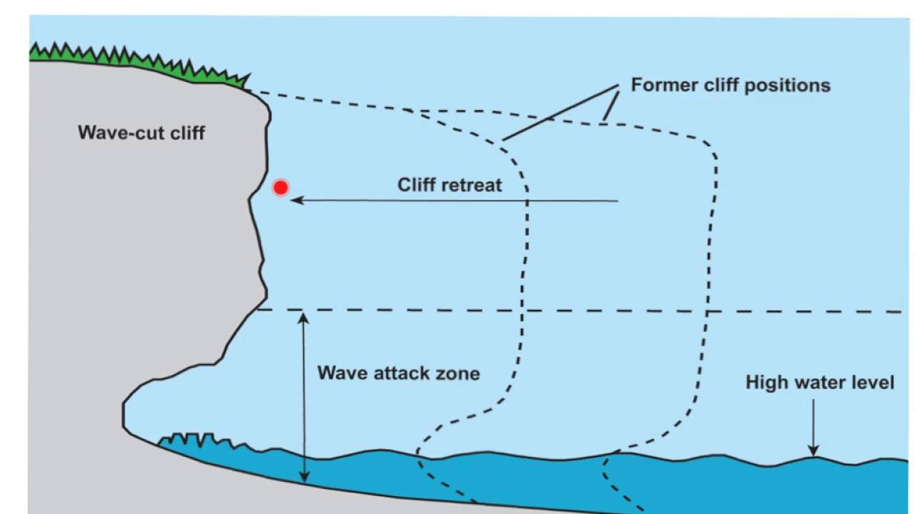
Rock erosion:
At the posted coordinates take a look around you at the caven, the surrounding cliff face and the nearby rock formations. All of these little caverns would once have been part of the coastline until coastal erosion caused the deterioration of the rock face.
Coastal erosion is typically driven by the action of waves and currents, but also by mass wasting processes on slopes, and subsidence (particularly on muddy coasts). Significant episodes of coastal erosion are often associated with extreme weather events (coastal storms, surge and flooding). On coastal headlands, such processes can lead to undercutting of cliffs and steep slopes and contribute to mass wasting. Coastal erosion is a natural process which occurs whenever the transport of material away from the shoreline is not balanced by new material being deposited onto the shoreline. Many coastal landforms naturally undergo quasi-periodic cycles of erosion and accretion on time-scales of days to years. This is especially evident on sandy landforms such as beaches, dunes, and intermittently closed and open lagoon entrances. Natural erosion can cause the formation of caverns, such as that at the posted coordinates.
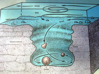
Potholes:
At WP1 you will be in a small cave or "pothole". A pothole is a circular or cylindrical hole in the rock which is produced by force of water and abrasion. A pothole is formed when a circular current of water carrying small pebbles and sediment begins to wear away at the surface. The force of water and the sediment it carries is greater than the resistance of the rock. Once the process has begun, it continues and the rock in that location continues to erode away.
Questions:
Q1. At the posted coordinates take a look at the surrounding cliffs. What colour are the cliffs and in your own words what causes this colouration?
Q2. At the posted coordinates you will see a cavern. How did this cavern form and what kind of stone is it formed from?
Q3. Standing in the middle of the cavern at the posted coordinates (so the middle of the main area of the cavern not the little side chambers), what is the height from the sandy bottom to the roof in the middle to the nearest 10cm?
Q4. At WP1 you will be inside a cave. How was this cave formed and how does it differ in formation to the cavern at the posted coordinates?
Q5. At WP1 you will need to wade inside of the cave to its centre. Standing (or swimming) in the centre of the cave, measure the height of the cave from the sandy bottom to the roof of the cave at WP1. What is the centimetre difference between the heights of the cavern at the posted coordinates and this cave at WP1? What process created the difference in the depth of these rock formations?
Please feel free to log this cache once you've completed the EarthCache requirements while waiting for a response to your answers. You will need to send me your answers to verify your find for this EarthCache by using the Message Centre.
References
Manifold, P. author, Manifold, P. photographer, Manifold, P. illustrator., & Rawling, T. J. (2017). Written in stone : reading the rocks of the Great Ocean Road. Melbourne : Philomena Manifold, Oct. 2017. Retrieved from http://ezproxy.deakin.edu.au/login?url=http://search.ebscohost.com/login.aspx?direct=true&db=cat00097a&AN=deakin.b3978669&authtype=sso&custid=deakin&site=eds-live&scope=site