このEarthCacheはGeocaching の公式ブログにて紹介されました。
This EarthCache was featured on the Geocaching Official Blog.
注意事項 (Please note)
①崖は崩落の可能性があります。ご注意ください。
②道路を横断する際には車に気をつけてください。
①This cliff has a possibility which will be broken. Be careful.
②Be careful. if you will cross the road.
阿蘇は現在も活発に活動中の火山です。そして過去の様々な火山活動の痕跡を通じて火山について学ぶことができる場所でもあります。
ここでは「スコリア丘」について考えてみましょう。
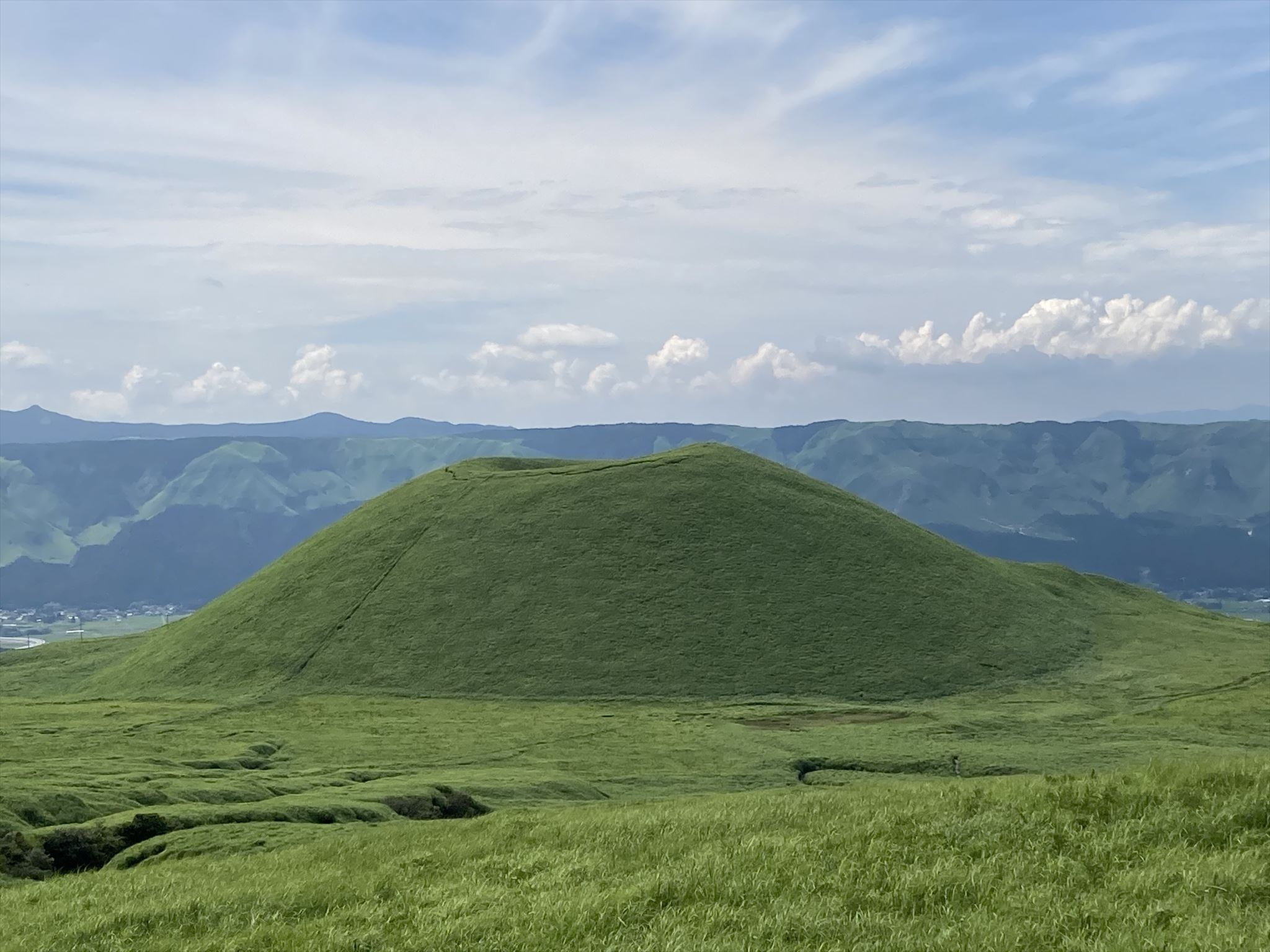
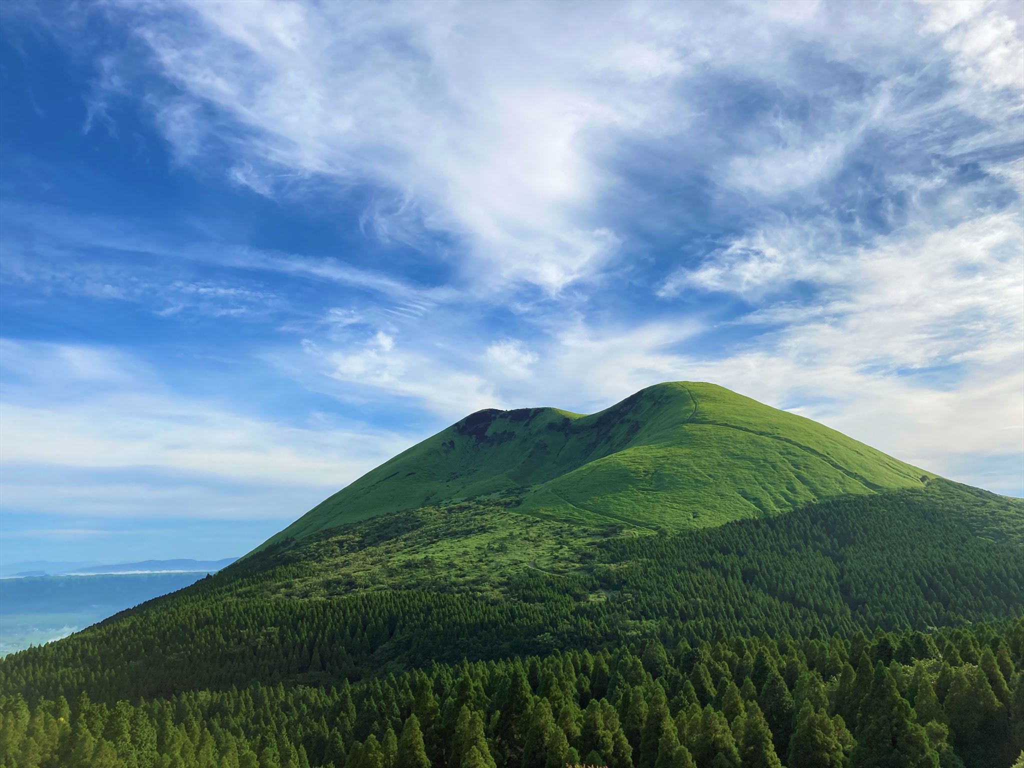
スコリア丘はスコリア(破片状の火山噴出物)が火口の周囲に堆積して生じた円錐形の火山体のことです。「米塚」・「上米塚」・「杵島岳」がその代表的なものです。
Mt. Aso is an active volcano. And it is also a place where you can learn about volcanoes through traces of past volcanic activity.
Let's learn about "Scoria Hill" this EarthCache.
The scoria hill is a cone-shaped volcano formed by scoria (fragmented volcanic products) deposited around the crater. "Komezuka",”Kami-Komezuka”,”Mt.Kishima” are the representative thing.
「米塚」(参考地点1)「Komezuka」(Reference point 1)
「杵島岳」(参考地点2)「Mt.Kishima」(Reference point 2)
阿蘇の代表的な3つのスコリア丘について地形図で観察してみましょう(下図参照)。 いずれも円錐形をした山体であることが分かります。
Let's observe the topographical map about three representative scoria hills of Aso.(Please refer to the figure below). It turns out that all are cone-shaped mountains.
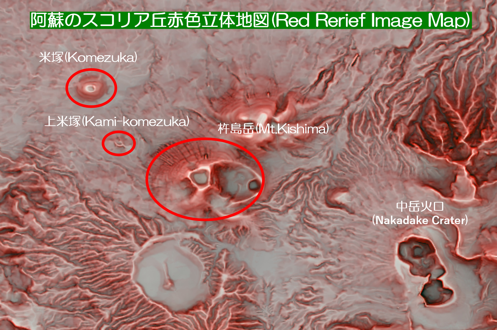 出典:株式会社ぶよお堂「赤色立体地図RRIM10_2016」
Source: Mapshop Co.Ltd. "RRIM_2016"
次に観察ポイントで実際に観察してみましょう。
「1.上米塚」(GZ)
スコリア丘の内部構造を直接観察できる、きわめて貴重な断面が見られるポイントです。崖の断面を観察してTASKに解答してください。
「2.米塚」(参考地点1)
約3,000年前に形成された典型的なスコリア丘で、国内では最も均整のとれたものの一つです。基底直径は約380m、比高は約80m。米塚を形成した一連の噴火活動で、大量の玄武岩溶岩も流出し、米塚の北~西側一帯に広く堆積しました。
「3.杵島岳」(参考地点2)
約3,500年前に形成された玄武岩のスコリア丘。山頂火口のほか、山頂の北西部および東麓に火口群がある単成火山です。
Next, let's actually observe at the reference points.
「1.Kami-Komezuka」(GZ)
Here is very valuable the place where you can directly observe the internal structure of the scoria hill.Please observe carefully here and answer TASK.
「2.Komezuka」(Reference point 1)
It is a typical scoria hill formed about 3,000 years ago and is one of the most balanced in Japan.The base diameter is about 380 m and the relative height is about 80 m. Through a series of eruptive activities that formed Komezuka, a large amount of basalt lava flowed out, and was widely deposited all over the north to west of Komezuka.
「3.Mt.Kishima」(Reference point 2)
Basalt scoria hill formed about 3,500 years ago. In addition to the summit crater, it is a monogenetic volcano that has craters in the northwestern part of the summit and in the east shore.
出典:世界大百科事典(平凡社)
Source: World Encyclopedia (Heibonsha)
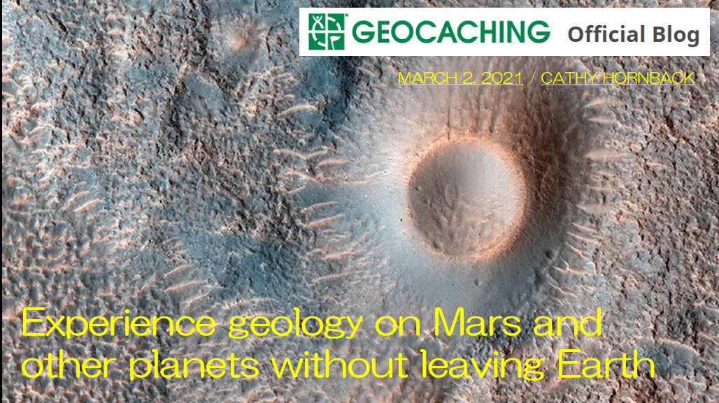
「火星のスコリア丘」
火星にもスコリア丘と思われる地形があります。この写真は2020年3月にシドニア地域で撮影されました。
「Scoria in Mars」
Mars also has a terrain that seems to be a scoria cone. This photo was taken in the Cydonia region in March 2020.

Image Credit: NASA/JPL/UArizona
1. 以下のTASKを実行してください。
2.キャッシュ名と解答をキャッシュオーナー(hikohohodemi)にメールしてください。
3. 答えはログに記入しないでください。
4.メールを送信したらファウンドログを上げてください。私の承認を待つ必要はありません。
1. Please carry out following TASK.
2. Please send e-mail this cache name and the answer to following questions to cache owner.(hikohohodemi)
3. Do not include this answer in your on-line log.
4. You do not need to wait for confirmation from me before posting online.
TASK 1
GZ(下の写真参照)で崖の下に落ちているスコリア片を観察してください。スコリアの表面にある穴は1cmより大きいですか?小さいですか?
また、どうして穴が空いたのでしょうか?あなたの考えを述べてください。
Please observe some scoria pieces at the cliff in the Kami-komezuka.(see the photo below) Are the holes on the surface of reddish brown scoria larger more than 1cm ? Are these small?
Why were there holes in Scoria? Please explain your thoughts.
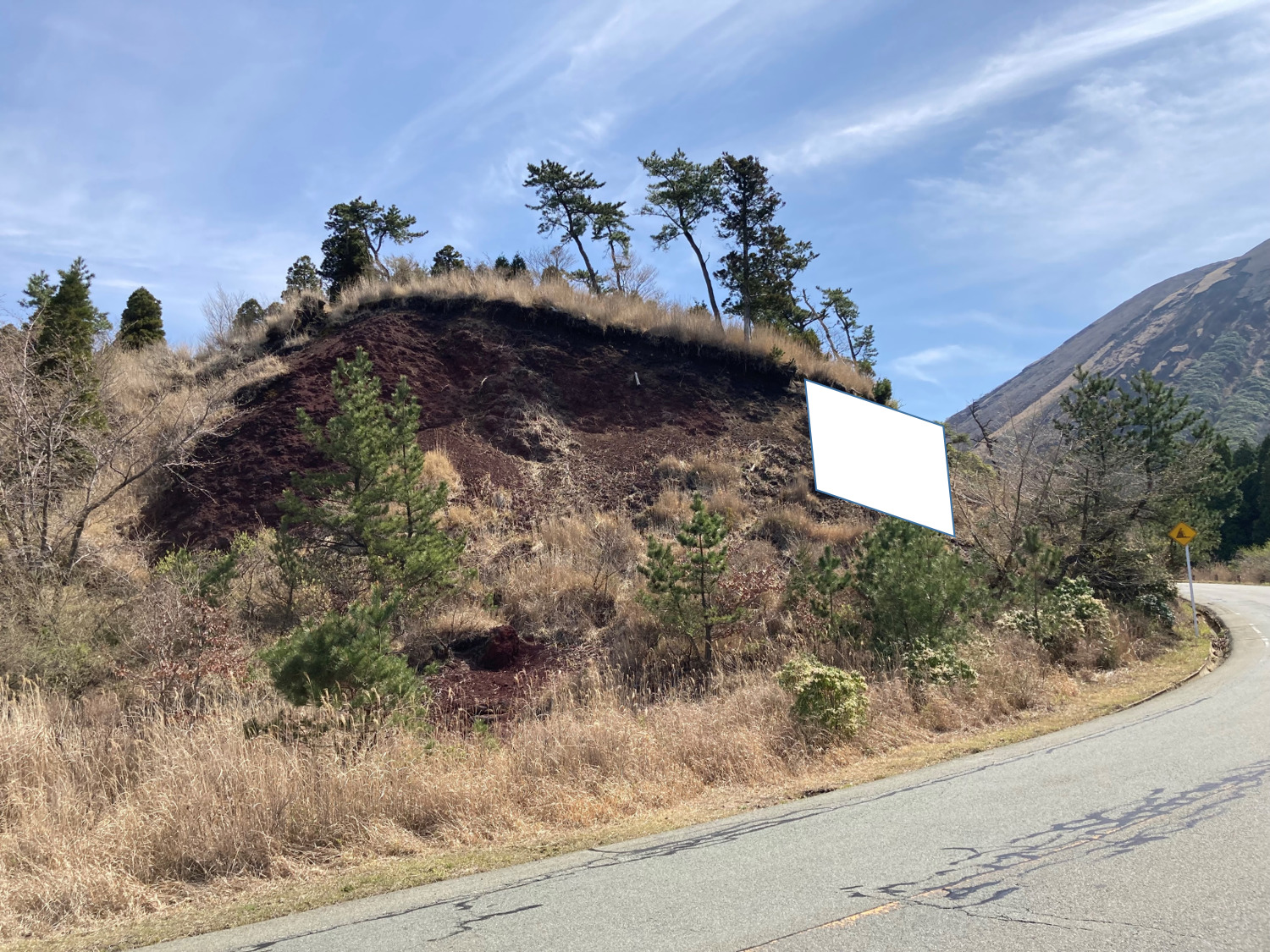
TASK 2
GZ(上の写真参照)で崖を観察してください。スコリアはほとんどが赤褐色をしています。しかし、崖の右端上部(白い部分)のスコリアは違う色をしています。何色でしょうか?
また、何故そうなったのかあなたの考えを述べてください。
Please observe the cliff at GZ(see the photo above). Almost core scoria is reddish brown in this cliff. However, the upper right side end has a different color. What color is it?
Also, please explain your thoughts on why.
OPTION
米塚(参考地点1)もしくは展望台(参考地点2)でスコリア丘を背景に、あなたまたはあなたのGPS機器の写真を撮り、ログにアップロードしてください。
Please upload the photo(you or your GPSr on the scoria hills at "Komezuka"(reference point 1) or "Observation Point"(reference point 2) to the log.