Welcome to the L Street Slide Zone,
created during the 1964 Great Alaska Earthquake.
On March 27, 1964 at 5:36 p.m., the largest earthquake ever to strike North America shook southcentral Alaska with ground movement lasting more than four minutes. The epicenter of the 9.2 magnitude quake was located in Prince William Sound, 80 miles east of Anchorage, at the relatively shallow depth of 25km. This earthquake is the second largest earthquake ever recorded in the world, after a M9.5 earthquake in Chile in 1960.
Purpose of visit: To observe a complex translatory slide site caused as the result of a large-magnitude earthquake and apply earth science to understand how the impact of this slide can still be seen here more than fifty years later. This Earthcache takes you on a four-stop tour of the L Street slide zone, along downtown Anchorage’s northwest side, where lands along the bluff between Ship and Chester Creeks moved outward in a generally northwestward direction. You will observe landforms visible today and correlate them to what was observed in the immediate aftermath of the L Street Slide.
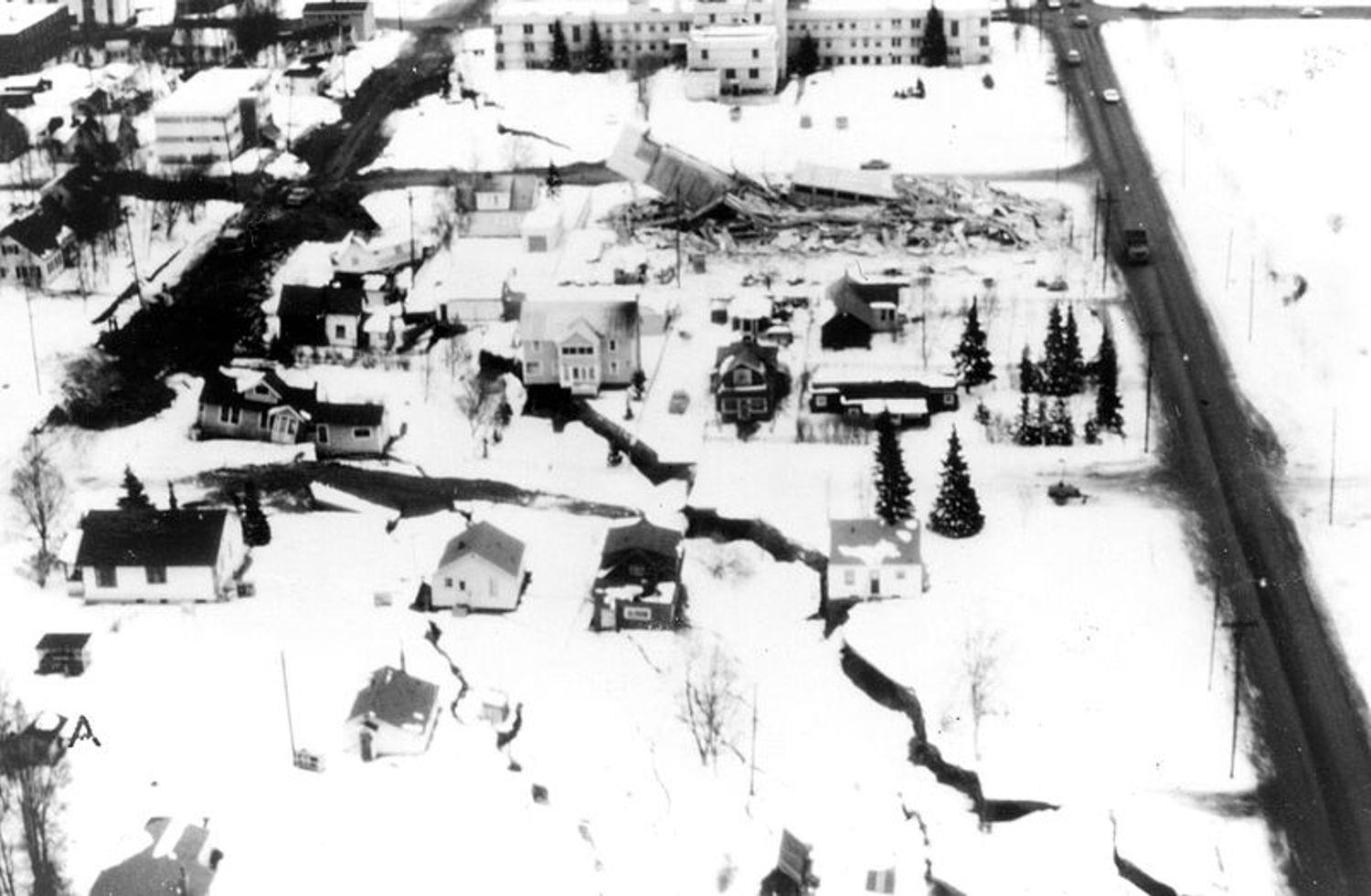
Aerial Photo – looking east from above a portion of the L Street Slide zone. View is from O Street across N and M Streets to L Street (visible at top of photo), centered between Eighth Avenue (at left) and Ninth Avenue (at right). The Delaney Park Strip is visible to the right (south) of Ninth Avenue. St Mary’s Residence Hospital (at top center of photo) was largely undamaged, while the remains of the totally-collapsed Four Seasons Apartment building can be seen one block below the Hospital on the corner of Ninth Avenue and M Street. Of note, the two houses seen at near upper left of the photo, on the northwest corner of Eighth Avenue and M Street, are in use today as professional offices – looking much as they did on the day of this earthquake.
Terms to understand:
Liquefaction describes a soil’s failure to remain cohesive and strong during a period of stress while it contains a large volume of water. Under too much stress (such as prolonged shaking from earthquake activity) the soil cohesion fails and the soil behaves like a fluid.
Graben is the name for the sunken section of land created behind the soil blocks moving along in a translatory slide. Several graben (or more) can be formed in a slide zone, and they are generally perpendicular in alignment to the direction of movement of the soils.
The diagram below illustrates a simplified view of the soil structure found at this L Street slide site, the Fourth Avenue slide site, and the Turnagain Heights slide site. Triggering of landslides by the earthquake was related to the soil mechanics of the Bootlegger Cove Formation (named after the downtown coastal subdivision where it was first identified), a glacial estuarine-marine deposit that underlies much of the Anchorage area at soil depths just above sea level. These soils were laid down by rivers draining glacial valleys just prior to the ‘Naptowne’ glaciation period (10,000–12,000 years ago). Naptowne-era gravels were laid down over most of Anchorage (and the Bootlegger Cover Formation soils) in the last glaciation event this area experienced. In general the Bootlegger Cove Formation consists of three physically distinct but gradational zones - an upper and a lower stiff competent zone and a central weak sensitive zone. Failures under the vibratory stress of the earthquake occurred chiefly in the central zone of Bootlegger Cove Formation soils, where low shear strength, high water content, and high sensitivity to stress are evident. The major destructive landslides in the Anchorage area moved primarily by translation (soil transferring relatively intact from one location to another on a mild grade), moving on nearly horizontal slip surfaces after loss of strength in the weakest layer of the Bootlegger Cove Formation. These slides occurred at locations involving flat-topped bluffs bounded by steep slopes facing lower ground – exactly like the terrain found here in the L Street slide zone.

A 30-block area was affected in the L Street slide. It extended northeast about 4,800 feet along the bluff, and had a maximum breadth northwest across the bluff of about 1,200 feet. It reached about a block and a half back from the bluff into thickly-settled residential and commercial neighborhoods of downtown northwest Anchorage. Despite lateral shifting of as much as 14 feet towards the northwest, remarkably little damage occurred, with most damage happening along the edges of the graben itself. The slide included the land west of K Street between Seventh and Third Avenues, and land northwest of a line from the intersection of K Street and Seventh Avenue to the intersection of S Street and Eleventh Avenue. The map below is overlaid on a 1964 aerial photo taken several days after the earthquake by Air Photo Tech, with the northwesternmost bluff line highlighted with a dashed magenta line and the graben highlighted with a broad dashed blue line. The bluff is still easily observable transecting the neighborhoods between Third Avenue and L Street all the way down to Thirteenth Avenue and S Street. However, it can be extremely challenging for uninformed visitors to find any evidence of the graben’s shapeform today across this neighborhood. At each location you visit, you’ll see how the city was reconstructed following the earthquake to make the graben virtually indistinguishable from surrounding terrain. Nonetheless, there are still discernible signs of the massive slide that occurred here, if you correlate the photos shown in this description with observations you'll make at these four points.
During your visit, you are to observe changes in landforms or elevation behind (southeast of) the bluff line and reference them to what was recorded as graben zones on the map below. This will help you see with your own eyes at ground level how the slide impacted the topography of this area more than fifty years ago.
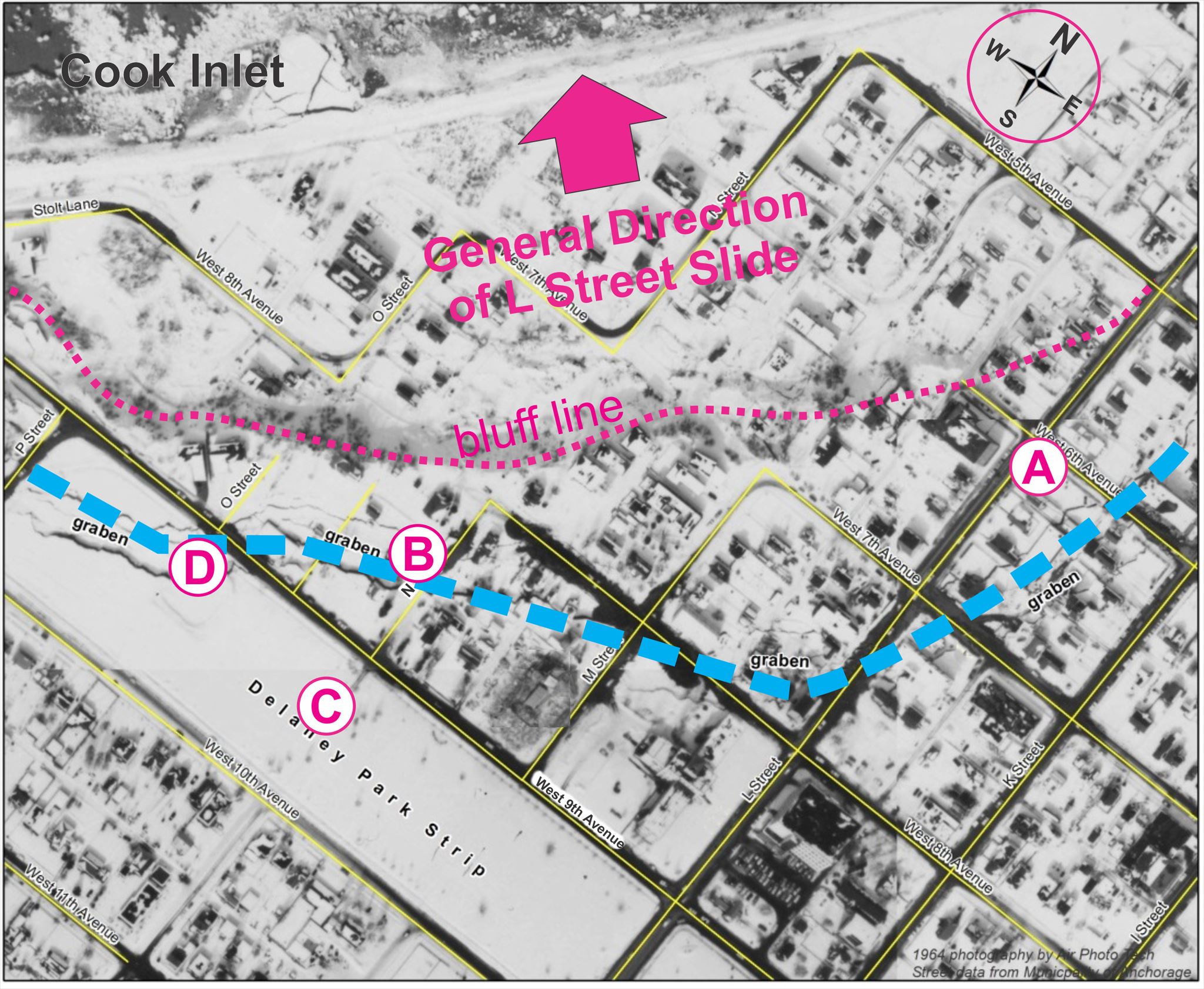
Dashed Magenta Line - the bluff Dashed Blue Line - the graben
Points A, B, C, D - the observation points
Your learning activity encompasses visiting four observation points, as shown above on the aerial photo-map. Please message or email the cache owner with the answers to the observations or measurements requested at each observation point. Logs without timely messages or emails to the cache owner will be deleted. Photographs recording your visit (especially summer photos within the lovely Centennial Rose Garden) are welcomed, but not required.
Point A) Standing at the listed coordinates of this earthcache, on the southeast corner of the intersection of Sixth Avenue and L Street, look south down L Street. Observe how the lane markings and street curbs along L Street shift twelve feet between the intersections of Seventh and Eighth Avenues. This is the block where the graben from the L Street slide actually crossed L Street itself. In the reconstruction following the quake, engineers offset L Street’s formerly straightline north-south path a total of twelve feet across this block to accommodate ground movement which had occurred, inadvertently creating a subtle reminder of the slide!
Which portion of the landscape shifted west here – lands to the north or lands to the south of the block between Seventh and Eighth Streets?
Point B) This is a block west of where the newly-constructed Four Seasons Apartment Building collapsed during the latter minutes of ground shaking during the 1964 Earthquake. It was adjacent to (but not within) the graben’s southeast side. The building wasn’t damaged by the slide which formed the graben, but from structural failure during the prolonged shaking. Standing here in the center of the block along N Street’s west side, between Eighth and Ninth Avenue, face west and allow your gaze to traverse slowly from the bluff line at right across to the Delaney Park Strip on your left. You are looking across one of the more visible areas of the graben (while standing in the exact center of the eastward aerial view in the first photo of this listing).
Describe the topography of the landscape in front of you while looking west – what shape does the surface have? (for example, is it flat? Is there a geologic term related to describing this location as part of a translatory slide?) To see the bluff up close, walk a half-block north of here to look over the edge of the bluff at apartments below, just behind a clump of spruce trees…
Point C) Enter the Centennial Rose Garden here in the center of the Delaney Park Strip, between Ninth and Tenth Avenue. Known to the Anchorage community as the Park Strip, Delaney Park is the oldest park in the city. It was established as part of the original Anchorage township plat in 1917, first used simply as a firebreak against the woodlands then extending across the entire southern side of the town. Its virtually flat surface, extending all the way from the bluff on the west towards the town’s eastern side across a 13-block span, made it useful for a wide variety of purposes. From 1922-1929 the community used the space both for a golf course and an airstrip (until Merrill Field was built on the town’s east side in 1932). This rose garden was built in 1967 (three years after this earthquake) to celebrate the centennial of Alaska's purchase from Russia, and is a renowned site where various rose varieties are trialed to prove their hardiness in northern climates. Go to the west entrance of the Rose Garden, and look westward towards the small bandstand on the Park Strip (Point D), visible a block away. Observe the slide-damaged Park Strip in the aerial photo-map to orient yourself.
Describe the topography of the landscape in front of you while looking west – what shape does the surface have? (for example, is it flat? Or does it have another shapeform?)
Point D) Make your way to the small concrete-platform bandstand from the Rose Garden. This bandstand is your last stop on your visit to the L Street slide zone. Relax here a moment and look back east towards the Rose Garden.
1. Based on the aerial photo-map, and what you see today, how did the events of the 1964 earthquake change this location’s position relative to the rest of the Park Strip to the east?
2. What geologic term names where this bandstand is located in the L Street slide zone?
3. Estimate the elevation difference in feet between here and the Rose Garden (Point C).
Please message or email the cache owner with your answers to the observations or measurements requested at each observation point. Logs without timely messages or emails to the cache owner will be deleted. Photographs recording your visit (especially summer photos within the lovely Centennial Rose Garden) are welcomed, but not required. Thank you sincerely for taking time to study this particular aspect of the 1964 Great Alaska Earthquake!
Published March 27, 2019 on the 55th anniversary of the 1964 Great Alaska Earthquake, and dedicated to the memory of the geologists and recovery workers whose post-quake studies and analyses contributed to safe recovery and rebuilding efforts while increasing dramatically our understanding of what occurs during massive earthquakes.
Resources used to develop this EarthCache (available online as downloadable PDF documents):
Effects of the Earthquake Of March 27, 1964 at Anchorage, Alaska
By Wallace R. Hansen
U.S. Geological Survey Professional Paper 542-A
A Guide To The Geology Of Anchorage:
A Commentary On The Geotechnical And Historical Aspects Of Selected Localities In The City
By R.G. Updike, C.A. Ulery, and J.L. Weir
Alaska Division of Geological and Geophysical Surveys, June 1986
Pictures are in the public domain from archives of the U.S. Geological Survey.
The photo-map was created from an Air Photo Tech photo from USGS archives.