注意事項 (Please note)
GZは海岸近くにあります。満潮時には近寄れない時がありますので、事前に潮位を確認ください。 (潮見表 )
GZ is near the coast. There are times when you can not get close at high tide, so check the tide level in advance.
関門海峡は本州最西端と九州北端の間の狭い海峡です。最狭部は下関市壇之浦(だんのうら)と北九州市門司(もじ)の和布刈(めかり)との間で、早鞆ノ瀬戸(はやとものせと)といいます。幅約650メートル、水深20メートル、潮流最高8ノットで、大潮時には1.6メートルにも及ぶ水位差を生じます。また、約500隻/1日の船舶が往来し、航路上の難所として知られています。
The Kanmon Straits is a narrow strait between the westernmost end of Honshu and the northern end of Kyushu.The narrowest part is called "Hayatomo-no-seto" between "Dannoura" in Shimonoseki (Honsyu Island) and "Mekari" in Moji (Kyushu Island).In "Hayatomo-no-seto", the strait is about 650 meters wide and 20 meters deep. Also, there is a maximum of 8 knots of tidal current, and tide level difference at the time of the high tide is as much as 1.6 meters.In addition, there are about 500 ships per day, and it is known as a difficult place on the route.
出典:第七管区海上保安本部 海洋情報部 HP
Source: 7th Regional Coast Guard Headquarters
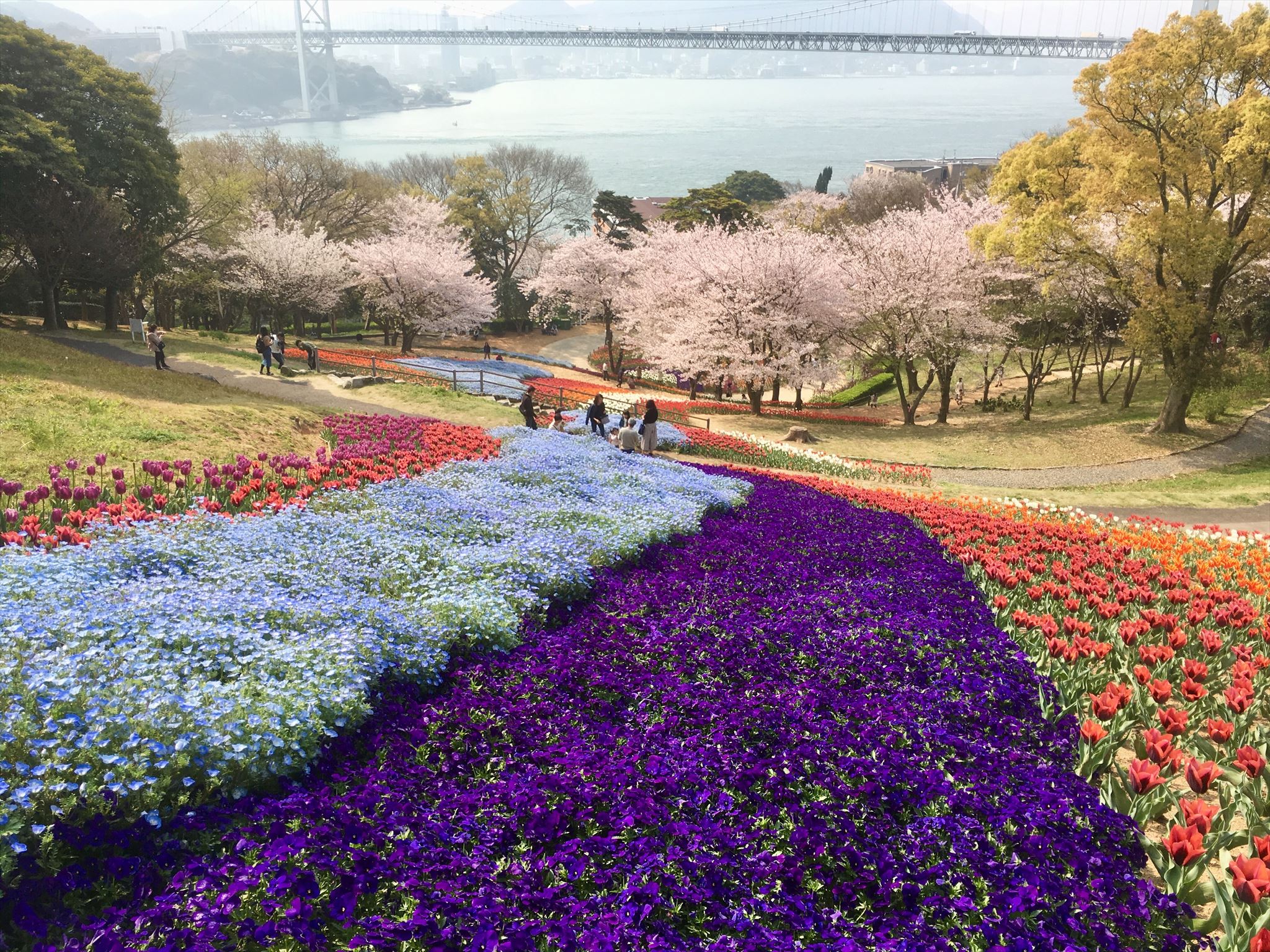 火の山公園(下関市)より望む門司・関門海峡 2019.04.07撮影
Downtown of Moji and Kanmon Straits from Hinoyama Park (Shimonoseki City) Shooting date:2019.04.07
関門海峡はどのようにしてできたのでしょうか?先ずは関門海峡周辺の地質を調べてみましょう。
海峡周辺の地質は中生代白亜紀の堆積岩である関門層群(砂岩・頁岩)、火成岩(ヒン岩、花崗岩)からなり、その上部に沖積層(砂・礫)が堆積したものです。火成岩は堆積岩である関門層群に貫入したもので、関門海峡は特に花崗岩が関門層群に広く貫入しています。また、関門層群のほとんどは火成岩の貫入による接触変質作用を受けて、硬質のホルンフェルスになっています。(下図を参照ください)
First, let's examine the geology around the Kanmon Strait.
Geology around the strait is composed of the Kanmon Group (sandstone and shale), which is a Mesozoic Cretaceous sedimentary rock, and igneous rock (porphyrite and granite). And the alluvial layer (sand, gravel) deposited on top of it. The igneous rock intrudes into the sedimentary rock, the Kanmon Group, and especially in the Kanmon Strait, granite penetrates the Kanmon Group widely. In addition, most of the rocks of the Kanmon group is subjected to contact alteration due to the intrusion of igneous rocks, and becames hard hornfels.(refer to the diagram below)
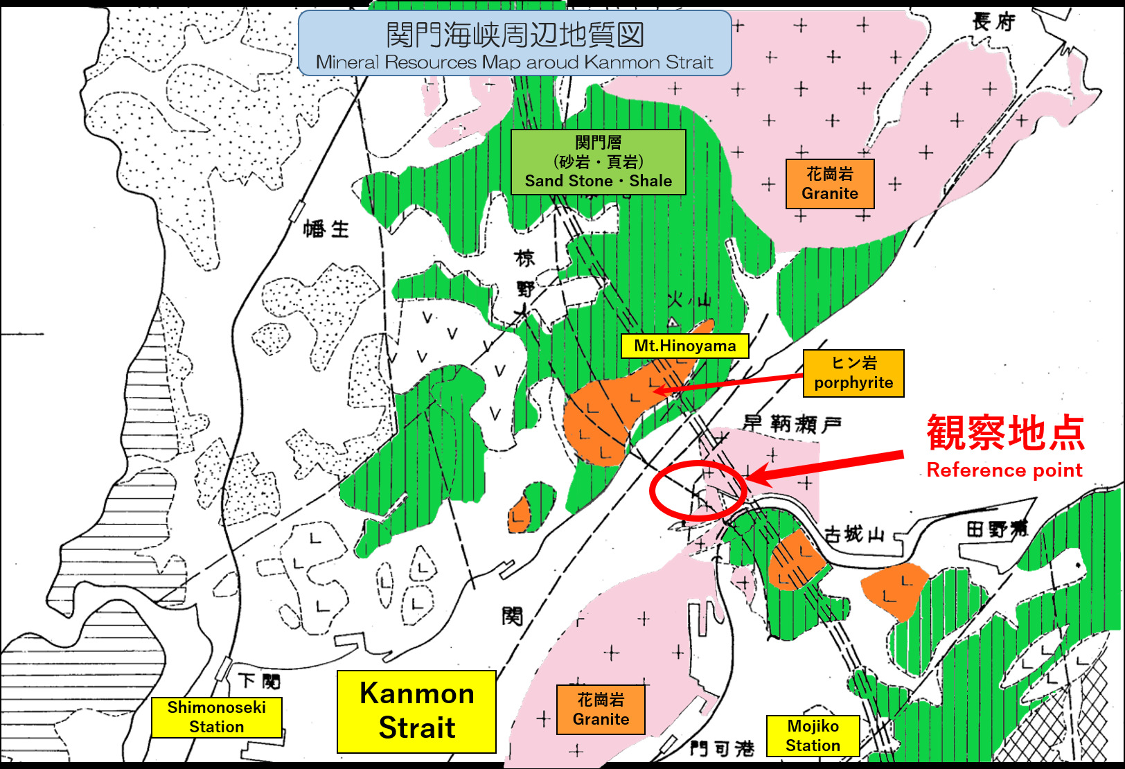 出典:「応用地質」16巻2号「新関門トンネルの海底区間地質調査」吉川恵也
Source: 「Applied geology」No.16-2 "Geological Surveys on the Underwater Portion of the Shin-Kanmon Undersea Tunnel" Keiya Yoshikawa
次に、どのような過程で現在の姿になったのか、考えて見ましょう。
①堆積岩である関門層群(砂岩・頁岩)にマグマ(火成岩)が貫入します。マグマに接触した堆積岩は硬質のホルンフェルスとなります。②マグマは冷えて花崗岩になります。次第に堆積岩は浸食されてホルンフェルスが露出します。③更に浸食されて花崗岩が露出します。花崗岩は風化しやすいためホルンフェルスより早く浸食が進みます。大きく浸食が進んだ凹部に海水が入り関門海峡ができます。
Next, let's think about how the Kanmon Strait became a present figure.
① Magma (Igneous rock) intruded into the Kanmon Group (sandstone and shale) which is a sedimentary rock. Sedimentary rocks in contact with magma became hard hornfels. ② Magma cooled and became granite. Gradually the sedimentary rock was eroded and hornfels was exposed. ③ Erosion progresses further and granite was exposed. Granite was eroded faster than Hornfels because it is easy to weather. Seawater entered the depressions where erosion had progressed, creating a strait.

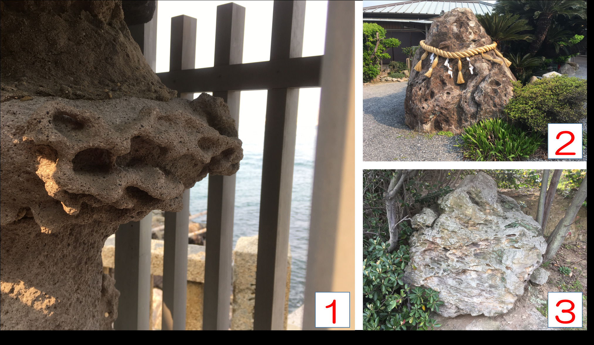
関門海峡は花崗岩が風化して誕生しました。風化にはいくつかの種類があります。そして、和布刈海岸ではタフォニと呼ばれる特徴的な風化の跡を見ることができます。
タフォニとは岩の表面に多数の窪みがハチの巣状になった状態をいいます。 ①観察地点1:和布刈神社には柱部の岩がハチの巣状になった灯篭(写真1)があります。また「丸い窪みが多い岩」がご神体(写真2)として祀ってあります。②観察地点2:門司埼灯台付近でも「楕円形の窪みが多い岩」(写真3)があります。
Kanmon Straits was born due to the weathering of granite.There are several types of weathering. And at the Mekari Caost, you can see the characteristic weathering mark called Tafoni.
Tafoni is a state in which many pits are shaped like a honeycomb on the surface of the rock.①Observation point 1: There is a lantern (Photo 1) in which the rock of the pillar has become a beehive in Mekari Shrine. In addition, "A rock with many round depressions" is enshrined as a divine object (Photo 2).②Observation point 2: There is also a rock with many oval depressions (Photo 3) even near the Mojisaki lighthouse.
タフォニは海水が原因となって起こる風化現象です。
海岸近くの岩は波などのよって飛び散った海水が沁み込んでいます。その海水が乾燥する時に、海水に含まれている塩類が結晶を作ります。その結晶が成長していく時に岩の表面を破壊して窪みを作って行きます。窪んでいる所ほど海水が沁み込みやすいので、より風化が進み、ハチの巣のような模様になっていくのです。
Tafoni is a weathering phenomenon caused by seawater.
The rocks near the coast is soaked into seawater splattered by waves.When the seawater dries up, the salts contained in the seawater make crystals.As the crystals grow, they destroy the surface of the rock and make pits. As the seawater is easily accumulated in the place where it is depressed, the weathering progresses more and it becomes like a beehive.
出典:「地層のきほん」著者: 目代邦康、 笹岡美穂、出版社: 誠文堂新光社
Source: "Basic knowledge of the stratum" by Kuniyasu Mokudai, Miho Sasaoka Published by Seibunndou-Shinkousya
1. 以下のTASKを実行してください。
2.キャッシュ名と解答をキャッシュオーナー(hikohohodemi)にメールしてください。
3. 答えはログに記入しないでください。
4.メールを送信したらファウンドログを上げてください。私の承認を待つ必要はありません。
1. Please carry out following TASK.
2. Please send e-mail this cache name and the answer to following questions to cache owner.(hikohohodemi)
3. Do not include this answer in your on-line log.
4. You do not need to wait for confirmation from me before posting online.
TASK 1
観察地点2で写真(3)の岩を触ってみてください。
岩は脆くて簡単に崩れますか?それとも硬く触っただけでは崩れませんか?
Please touch the rock of photograph (3) at observation point 2.
Is the rock fragile and easily broken up? Or does it not break just by touching?
TASK 2
観察地点2で写真(3)の岩と波打ち際の岩(灯台周辺)を見比べてください。どちらの方が窪みが多いですか?
それは何故でしょうか?あなたの考えを述べてください。
Compare the rock in the picture (3) and the rock near the lighthouse (around the lighthouse) at observation point 2.Which one has more pits?
Why is that? Please explain your thoughts.
OPTION
海岸で関門架橋とあなた、またはあなたのGPS機器の写真を撮り、ログにアップロードしてください。
Please upload the photo(you or your GPSr and Kanmon Bridge) to the log.