Martinique Beach / Barrier Spit EarthCache
Martinique Beach / Barrier Spit
-
Difficulty:
-

-
Terrain:
-

Size:  (other)
Please note Use of geocaching.com services is subject to the terms and conditions
in our disclaimer.
Martinique Beach / Barrier Spit
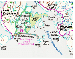
Martinique Beach Provincial Park is located in East Petpeswick, Halifax County, Nova Scotia, approximately 12 kilometres south of the community of Musquodoboit Harbour. Situated at the mouth of the Musquodoboit Harbour estuarine system, the 60 hectare coastal park opened in 1971 and is popular for its extensive sand beach and the opportunities it provides for coastal recreational activities.
Martinique Beach Provincial Park, as well as the Martinique Beach Game Sanctuary and adjoining Nature Conservancy of Canada lands, is part of the Musquodoboit Harbour Outer Estuary which has been designated as a wetland of international importance under the Ramsar Convention on Wetlands. The estuary is also recognized by Birdlife International as an Important Bird Area for waterfowl.
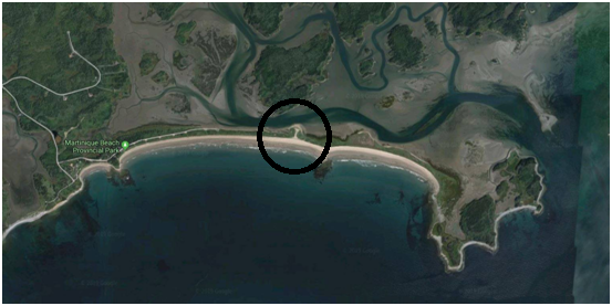
Note on the map below the break though just past the middle where the ocean has broken through the barrier during a storm event.

Martinique Beach is one of the longest sand barriers along the Eastern Shore of Nova Scotia. The sand barrier is anchored by a series of bedrock outcrops and to the mainland at Whale Point. On the landward side Martinique Beach shelters and protects the Musquodoboit River estuary and the extensive and the highly productive estuarine salt-marshes, wetlands and intertidal flats in Musquodoboit Harbour from ocean storm events.

What are Coastal Barrier Landforms?
Coastal barriers are unique landforms that provide protection for diverse aquatic habitats and serve as the mainland's first line of defense against the impacts of severe coastal storms and erosion. Located at the interface of land and sea, the dominant physical factors responsible for shaping coastal landforms are tidal range, wave energy, and sediment supply from rivers and older, pre-existing coastal sand bodies. Relative changes in local sea level also profoundly affect coastal barrier diversity.
Barriers primarily consist of unconsolidated sediments (sand, gravel, etc.). They buffer the mainland from the impact of storms and protect direct wave attack by the fastland (non-wetland) portion of the coastal barrier as well as protecting and maintain production estuarine systems.
Development of Coastal Barriers / Spits
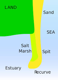
Barrier spits or coastal barriers that extend into open water and are attached to the mainland at only one end. They can develop into a bay barrier if they grow completely across a bay or other aquatic habitat. On the other hand, bay barriers can become spits if an inlet is created.
The length and width of barriers and overall morphology of barrier coasts are related to parameters including tidal range, wave energy, sediment supply, sea-level trends, and basement controls. The amount of vegetation on the barrier has a large impact on the height

Spits occur when longshore drift reaches a section of headland where the turn is greater than 30 degrees. The spit will continue out into the sea until water pressure (e.g. from a river) becomes too great to allow the sand to deposit. Vegetation may then start to grow on the spit, and the spit may become stable and often fertile. In this case the tidal flow of the harbour has kept it clear.
To log this Earthcache visit the viewing location. Please answer the following questions and send in a timely manner to my geocaching profile or email. Answers not received will result in deleted logs.
1. Describe the vegetation and sand on the beach?
2. What is the elevation at the top of the sand?
3. How wide is the barrier spit?
4. Do you think the beach will grow more, erode or wash over (break through)?
5. [REQUIRED] In accordance with the updated guidelines from Geocaching Headquarters published in June 2019, photos are now an acceptable logging requirement and WILL BE REQUIRED TO LOG THIS CACHE. Please provide a photo of yourself or a personal item here to prove you visited the site.
Additional Hints
(No hints available.)