This earthcache has 2 stages, one below and the other on top of the ridge of the Tymon/Greenhills Road Esker.
An esker is a long, snakelike ridge of sediment deposited by a stream that ran under, over, or within a glacier.
Eskers were formed in the last Ice Age, around 10,000 years ago around the time of the Glacial maximum when the glacier was slow and sluggish. The Greenhills Esker is formed within an area of Lower Carboniferous limestone, but the esker itself is Quaternary in age.
Eskers generally contain a wide variety of materials, ranging from fine lacustrine silts and clays, sorted silts, sands, gravels and large boulders. Their sediment can be well stratified or layered and their particles can have travelled up to 15km. The sands and gravels within the feature are comprised chiefly of limestone clasts.
When glaciers melt, they produces meltwater that can flow on top, within, and underneath the glacier through channels. This meltwater moves large quantities of sediment from the glacier. The sediments deposited by glacial meltwater are called outwash. The running water that transports them sorts and layers them. Variations in meltwater influence the discharge of sediment Eskers can be up to 150 m high and as wide as 500 m wide and can extend from a few hundred meters to over 15 kilometers in length.
The esker feature is important in that it records faithfully the ice movement across this area of Dublin which is along its orientation. An ice marginal fan is a hill left high and dry when the ice retreats away from a locality. Associated sands and gravels along the Greenhills Road, northeast of the esker, are probably part of an associated ice marginal fan .
Warren and Ashley (1995) proposed that there are 4 different types of eskers (as cited in Tubridy and associates 2006). Debate continues as to which type of meltwater streams formed this esker. Eskers are usually formed from the deposits of meltwater streams, sometimes by partial or total blocking of channels.
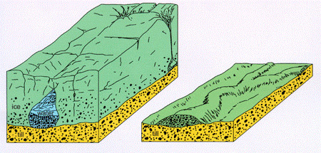
Esker Formation
1. An englacial or tunnel filled esker is formed when meltwater flows in a tunnel inside a glacier. This gives rise to continuous ridge eskers, either singular or multiple. Slower running streams were more likely to deposit sediment and this was laid down within the tunnel. Increasing amounts of sediment lying in the tunnel and the combined water pressure could raise height of the tunnel to allow the water to continue flowing. Eskers can form as a series of ridges, rather than being continuous due to the amounts of sediment being laid down when meltwater flow was slower. Once the glacier melted the sediment in the tunnel was lowered to the ground and laid down parallel to the underground river.
2. Subglacial eskers are formed by water running below a glacier. They are not only driven by gravity like regular rivers, but also by the hydrostatic pressure of the overlying ice. The confinement of the surrounding ice can in some cases allow the river to flow uphill or over obstacles resulting in undulating long profiles.
3. Eskers can also be formed in ice channel fills. This happens when sediment is deposited in open, ice walled channels (with no roof) between glacier bodies.
4. Alternatively there can be segmented tunnel fills, formed during pulsed glacier retreat.
Beaded eskers create lines of successive sand and gravel hills which were deposited during pulsed glacier retreat. This occurred under water ponded at the edge of the ice, and they are oriented parallel to ice flow. They may also be due to seasonal fluctuations in melt water, with more ice melting in Summer, resulting in greater deposits. Additionally eskers may be uneven due to the slumping of overlaying gravel after the ice melted. This can also result in irregular or discontinuous features, such as a string of small hills. These hills are called beads.
Esker Formation Source: Geologic-org
At Stage 1 you can see a characteristic feature of the Esker on the Greenhills Road. The esker stands as a ridge, with the land falling off to both sides of its long axis. While much of the esker itself has been removed by historical quarrying of its constituent sands and gravels, fragments of the feature remain intact. Where present the esker ridge is a striking feature, standing proud of the flat landscape of till (boulder clay) upon which it was deposited. Its soil is light, sandy, and lime-rich .
Stage 2 brings you close to Tymon Lane. Here you get a birds eye view and are stading on the ridge of the Esker. Note the height difference in meters between the two locations. You will find the additional information you need here on the Meadow Wildlife sign.
Rosaleen Dwyer, the Heritage Officer with South Dublin County Council, said:
“The Tymon Esker is really one of the gems in the crown of South Dublin County.
“The biodiversity on that one small spot is huge, with a recent insect survey discovering 96 species.
“What was exciting about the survey is that it uncovered a species of bug called a True Bug and the discovery in Tymon Esker was only the fifth ever record of this bug in Ireland.
“And, at all of the other four sites they only recorded females, but in Tymon Esker they recorded both males and females which is amazing.
“There are also butterflies and rare moths, such as the Burnet moth which is very rare in an urban environment, and we have also identified three endangered species of bee.
There are also 15 rare bee orchids growing on site, which are more common to areas like East Clare and the Burren, and around 150 pyramid orchids.”
The Greenhills road was diverted in the 1960s and changed so that it ran closer to the Cuckoo’s Nest. Prior to this alteration the lane ran over the highest point of Greenhills. Sand and gravel had been removed leaving a dangerous near vertical drop on both sides of the road. A new section was made that ran level with the floor of the sandpit. Additionally sand from the esker was used in the construction of pathways during the development of the Tymon park.
The siting of Tymon Castle, now in ruins and nowadays the site of Tymon Park’s Ranger Station, was purposely on top of one of the esker’s highest hills, depicted beautifully in an eighteenth century painting by Gabriel Beranger. In fact it seems as if eskers are a type of endangered species.
The Greenhills road and Tymon Lane are only a part of The Eiscir Riada, a ridge or continuous line of gravel hills whose ridge extends to Esker of Lucan, then south of the Liffey, near Celbridge, across that river near Clane onwards to Donadea, and onwards as far as Galway.
The Esker Riada provided a route through the bogs of the Irish midlands, since ancient times, forming a highway joining the east and west of Ireland. Its ancient Gaelic name is ‘An tSlí Mhór’, meaning ‘The Great Way’. In contrast with the surrounding bog lands, the glacial sands typical of the eskers provided well drained and relatively good quality land.
Pre-Christian travellers on the Esker Riada would have been coming and going to places like Tara, and the Rath of Feerwore (where the Turoe Stone originally stood). Earlier still, they would have used it for trips to Newgrange - which was built around 3,100 BC. In fact the main N6 Dublin to Galway road still closely following the path of the Eiscir Riada
The English word Esker is derived from the Irish word “eiscir”.
To log this earthcache as a find send me your answers to the following questions:
-
Why do you think Eskers allow biodiversity to flourish?
-
What type of Esker do you think this is and why ?
-
At Stage 2: how many meters do you think you are above the starting point coordinates you stood at
- Take a photograph and include a GPS in it, or alternatively do a thumbs up gesture. It is not necessary to show your face in the photo. Please do not reveal answers in your photograph.
***While you are at the biodiversity sign at Stage 2 you might consider to doing the traditional cache GC86A55 Biodiversity along the Tymon Esker.***
Once you have emailed you answers do not wait to log your find online; please send me your answers via my profile page and I will contact you if there is any problem. Online logs without any email will be deleted if the email is not received within a reasonable period of time
A very BIG thanks to Dr. Sarah Gatley and Dr. Robbie Meehan, Geologists at the Head Geological Heritage & Planning Programme, Geological Survey of Ireland Haddington Road, Dublin 4 who kindly shared their expertise with me and were so helpful!!!
Happy Caching