The Middlebrook encampment was a seasonal encampment of the Continental Army, commanded by General George Washington, during the American War for Independencenear Middle Brook in Bridgewater Township, New Jersey (between Martinsville and Bound Brook) in 1777 and again in 1778–79. The site includes part of the ridge of the First Watchung Mountain. Its position provided a natural fortress not only protecting the Continental Army but also overlooking the plains towards New Brunswick, where the British forces were stationed in 1777. The strategic strength of the position contributed ultimately to the success of the Continental Army by lengthening the war and wearying the British forces.
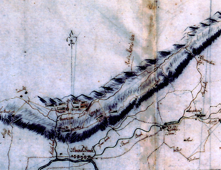 ” Original Middlebrook Encampment Map"
The original map was done by Captain Scull (listed as Snell is some places) a cartographer in the 11th Pennsylvania Regiment, commanded by Colonel Hampton. He joined Erskine's geographers department in 1778. Robert Erskine was Washington's map maker. A detailed account of the maps William Scull produced while he was working under Erskine and his successor, Simeon De Witt, that are now in the collections of the New-York Historical Society.
First Middlebrook encampment (1777)
During the winter of 1776–77, Washington initially encamped the Continental Army at Morristown, New Jersey. After his outpost garrison at Bound Brook was surprised and routed during the Battle of Bound Brook on April 13, 1777, Washington moved the encampment closer to Bound Brook to the Middlebrook encampment on May 28 and stayed there until July 2. A total of 8,298 soldiers were housed in the encampment, but 2,660 of them were sick or disabled, unable to fight. In contrast, the British maintained a force of about 17,000 near New Brunswick, New Jersey. From the heights of the Watchung mountains, Washington could monitor and counteract British movements. When General Howe decided to move against Philadelphia, concern over the threat by the Continental Army made him choose the safer sea route instead of the faster land route. This led to a significant delay in operations for the British and disrupted plans to help General Burgoyne in northern New York. On June 30, Howe moved his troops to Staten Island in preparation for his Philadelphia campaign, and two days later Washington left Middlebrook and moved the army to Pompton Plains.
In May of 1777, Washington moved his small army of about 6-8,000 men from his winter encampment at Morristown to the Middlebrook Heights, to observe the British troops at New Brunswick and Perth Amboy. Wayne's Brigade, commanded by General Anthony Wayne, from Pennsylvania was camped at the top of the first range of the Watchung Mountains in an area extending west from the intersection of Vosseller Ave. and Hillcrest towards Chimney Rock. They converted the area into a natural fortress. From this mountain, Washington kept an eye on the British in New York and New Brunswick. More importantly , he was in a position to flank the British if they attempted to cross New Jersey to Philadelphia.
Second Middlebrook encampment (1778–79)
Washington used the area around Middlebrook as a cantonment site, known as the Middlebrook Cantonment, during the winter of 1778–79. He brought about 8,000–10,000 troops to the camp site by November 30, 1778. Soldiers constructed cabins from logs covered with clay similar as they had done at Morristown. The Main army, consisting of the Virginia, Maryland, and Pennsylvania Brigades, with the Delaware regiment, the artillery Corps, and the artisans and attached support units, were along the base of the Watchung Mountains. Here they were protected from some of the weather, had a good supply of trees for construction and firewood, and were supported by a generally patriotic population, with an active militia.
Washington himself rented the Wallace House (now converted to a museum) in Somerville for four months and paid Wallace $1,000. General von Steuben lived at the Staats House in South Bound Brook. General Henry Knox lived at the Jacobus Vanderveer House near Pluckemin with the Continental Artillery camped at the Pluckemin Continental Artillery Cantonment Site. Nathanael Greene lived at the Van Veghten House in Finderne. The main body of the much larger British army was at New York. The camp was closed on June 3, 1779 when Washington led his army to Highlands, New York.
The Virginia troops were posted just west of the gap where Middlebrook creek flows out of the mountains, at Chimney Rock. The Virginia position extended along today's Foothill Road. The Maryland Brigade was posted east of the gap, past Vossler Avenue along what is now Middlebrook Rd. almost to Mountain Avenue. The Pennsylvania Brigade were posted south, at Weston, in today's Manville. Several miles north west along the ridge, at Pluckemin, the Artillery Corps was stationed, with an extensive academy/barracks construction.
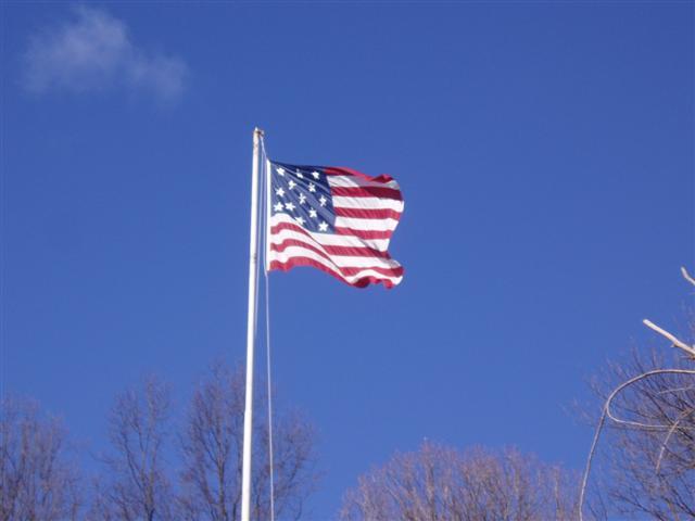
First flag: June 1777
When the 13-star flag was officially adopted by Congress in 1777, the first place it was flown over continental troops was at Middlebrook.
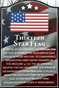
It is largely conceded that it was at the Middlebrook encampment that the first official flag of the United States was unfurled, after a law to adopt a national flag had been passed by Congress on June 14, 1777. This event is commemorated annually since 1889 on July 4 with a changing of the flag, a reading of the Declaration of Independence, and the delivery of an historical address at the Washington Camp Ground. Also, by special order of Congress, a Thirteen Star Flag is flown 24 hours a day at the Washington Camp Ground.
The 1777 Hopkinson flag is generally believed to be the first. Hopkinson was a delegate to the Continental Congress from New Jersey and a signer of the Declaration of Independence. The so-called Betsy Ross flag was more likely a flag used for celebrations of anniversaries of the nation's birthday. Her descendants claimed it was the first flag, but there is no evidence of that. The first documented usage of this flag was in 1792.
 ”the 13-star flag"
 ”the 13-star flag plaque"
This cache is one of "The American Revolution Geo~Trail" caches throughout New Jersey. These program geocaches are hidden at historic locations which have a connection to important New Jersey's American Revolutionary War history. To participate in the optional Geo-Trail, after you find the geocache, locate the secret code and record it into your passport which you will print from the Geo~Trail website. Information at njpatriots.org
 ”njpatriots.org"
The Northern New Jersey Cachers, NNJC is about promoting a quality caching experience in New Jersey. For information on The Northern New Jersey Cachers group you can visit: www.nnjc.org.
 nnjc.org & metrogathering.org, & njpatriots.org