ITALIANO
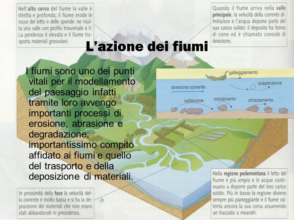
In geografia, una gola (detta a volte anche forra o orrido, indicata con l'anglicismo canyon) è una valle profonda con pareti ripide. È il risultato di fenomeni erosivi che si verificano quando un fiume o un torrente incidono vigorosamente il proprio letto in rocce coerenti e molto resistenti, generando valli strette, profondamente incassate nelle formazioni erose e con pareti molto ripide, talora strapiombanti. Spesso l'andamento è meandriforme.
L'erosione avviene soprattutto per azione meccanica abrasiva da parte del carico solido (massi e ciottoli) che il corso d'acqua trasporta al fondo, per saltazione e trascinamento, durante gli eventi di piena. L'effetto di tali eventi erosivi, proiettato nel tempo, genera forme spettacolari per la loro profondità.
La formazione di gole può concentrarsi preferenzialmente in masse rocciose indebolite da faglie o fratture (o più in generale discontinuità nelle quali tenda a canalizzarsi lo scorrimento delle acque) oppure può essere l'evoluzione di crolli di pareti e soffitti di grotte, frequenti in zone carsiche.
Le forre possono originarsi anche nei casi di corsi d'acqua a regime torrentizio, in cui a seguito delle piene stagionali consegue un elevato trasporto di detriti e di conseguenza un'erosione più marcata del fondo; si pensi ad esempio alle fiumare dei climi semi-aridi e gli uadi di quelli aridi.
Infine le gole possono nascere in corrispondenza a gradini di confluenza causati dal modellamento dei ghiacciai, laddove un ghiacciaio minore si univa ad uno principale con maggiore capacità erosiva. In questo caso, allo scioglimento del ghiaccio, la valle laterale sospesa è assoggettata ad erosione accelerata da parte del corso d'acqua che la percorre, inizialmente formando una cascata ed in seguito evolvendo nell'approfondimento della gola (la maggior parte delle gole delle Alpi sono dovute a questo fenomeno e si sono create negli ultimi 12.000 anni, dopo l'ultima glaciazione, il Würm).
La forra di Ponte Alto è un luogo di straordinaria suggestione paesaggistica.
Un tempo il Fersina, dopo aver percorso la Val dei Mocheni, si dirigeva verso sud-est lungo la Valsugana e confluiva nel Lago di Caldonazzo.
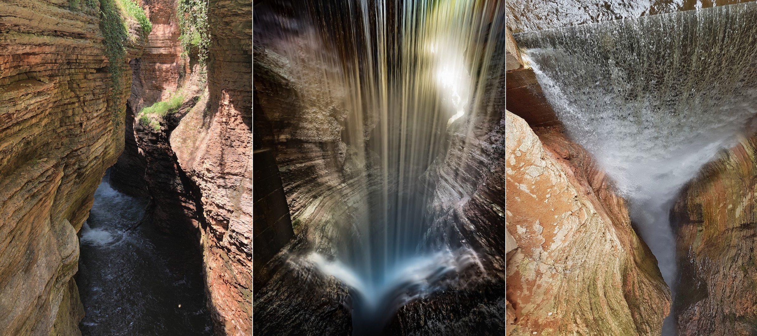
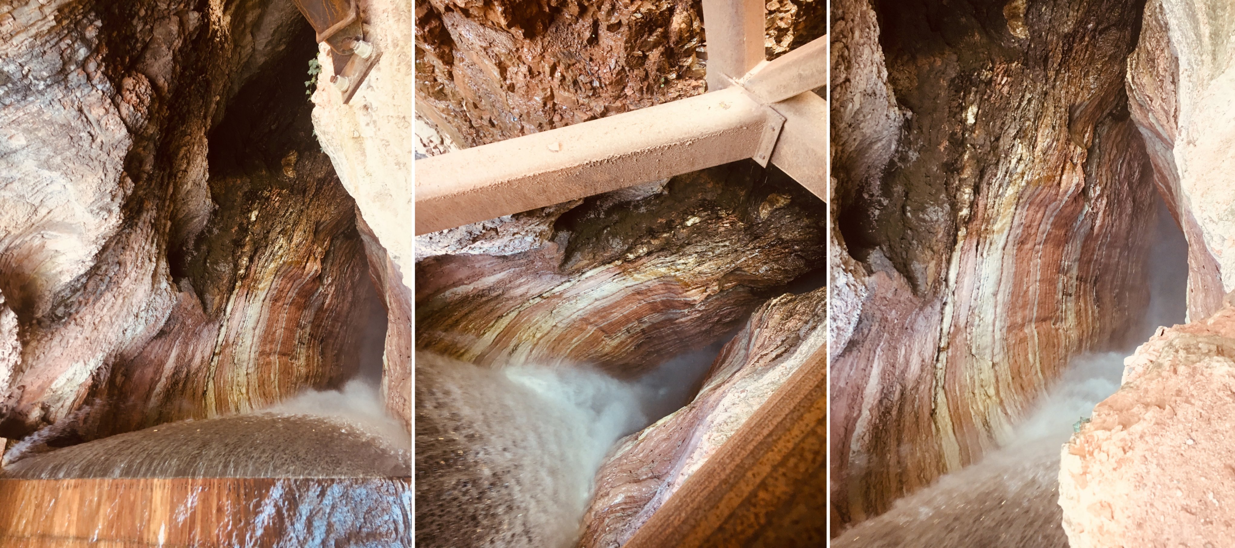
Circa 7000 anni fa i detriti depositati dai ghiacciai, in ritiro dopo la fine dell'ultima glaciazione, si accumularono in un conoide che dalla Vigolana scendeva verso la piana di Pergine, creando una “diga” che costrinse il Fersina verso ovest, nel suo corso attuale. Il torrente ha quindi dovuto farsi strada erodendo strati di rocce calcaree depositate nel corso di ben 140 Milioni di anni, fino a creare una forra profonda un centinaio di metri che separa le pendici del Monte Celva da quelle del Calisio. L’incisione in taluni punti si restringe in modo impressionante; dall’alto non si riesce a tratti a vederne il fondo in quanto il torrente ha scavato anche sui fianchi, spostandosi di lato.
Scendendo nella forra, nei pochi punti accessibili, ci si immerge in un mondo cupo e ombroso, saturo di umidità. Qua e là, su qualche balza, crescono gli ultimi alberelli e isolati esemplari di tasso, miracolosamente abbarbicati. Sulle pareti strapiombanti, fradice per lo stillicidio, si sviluppano delicati tappeti di capelvenere e cuscini di lingua di cervo, una splendida e rara felce, con lunghe foglie verdissime e lucide. Incuranti del frastuono prodotto dal torrente vorticoso, il merlo acquaiolo e la ballerina gialla fanno la spola in cerca di cibo tra gli spruzzi incessanti.
Per loggare questa earthcache recati alle coordinate indicate e cerca le informazioni necessarie.
Per motivi di sicurezza la forra è accessibile solo se accompagnati da una guida.
Orari delle visite: sabato e domenica (aperture straordinarie in occasione delle festività) dalle 10 alle 18.
Costi: 5 € adulti e 3 € bambini sotto i 12 anni.
Per maggiorni informazioni consulta il sito: www.orridopontealto.it.
Rispondi alle seguenti domande, inviandomi un messaggio. Non occorre che attendi la mia conferma per inserire il log; ti scrivo solo se trovo degli errori. I log senza l’invio delle risposte non saranno accettati.
Domande:
1. Vai sulla terrazza panoramica, alle coordinate del virtual stage 1. Oltre il ponte e la cascata puoi vedere tanti detriti portati dal fiume (ciottoli di varie dimensioni). Che tipo di rocce sono? Qual è il nome di questa roccia?
2. Scendendo, si notano molto bene le stratificazioni della roccia sulle pareti della forra. Da che tipo di roccia sono formate le pareti? Come si chiama questa roccia e di che colore è?
3. Puoi spiegare come mai si è formata questa forra?
4. Recati alla seconda terrazza panoramica alle coordinate del virtual stage 2 e osserva in basso il torrente. La cascata si è formata tramite il processo di erosione oppure è stata costruita? Quanto è alta?
5. All'ingresso, appeso sulla sinistra, c'è un cartello con le norme di sicurezza. Qual è la seconda norma di sicurezza?
6. E’ facoltativa, ma molto gradita una tua foto nel log.
ENGLISH
In geography, a gorge is a deep valley with steep walls. It is the result of erosive phenomena that occur when a river or a stream vigorously incise its bed in coherent and very resistant rocks, generating narrow valleys, deeply embedded in eroded formations and with very steep walls, sometimes overhanging. Often the course is meandering.
The formation of gorges can be concentrated preferentially in rocky masses weakened by faults or fractures (or more generally discontinuities in which the flow of water tends to be channeled) or it can be the evolution of collapses of walls and ceilings of caves, frequent in karstic areas.
Gorges may also originate in the case of torrential streams, in which following seasonal floods there is a high transport of debris and consequently a more marked erosion of the bottom; consider for example the streams of semi-arid climates and the wadis of arid ones.
Finally the gorges can be born in correspondence of confluence steps caused by the modeling of the glaciers, where a minor glacier joined to a main one with greater erosive capacity. In this case, when the ice melts, the suspended side valley is subjected to accelerated erosion by the watercourse that runs through it, initially forming a waterfall and then evolving into the deepening of the gorge (most of the gorges of the Alps are due to this phenomenon and have been created in the last 12,000 years, after the last glaciation, the Würm).
The gorge of Ponte Alto is a place of extraordinary scenic beauty.
About 7000 years ago the debris deposited by the glaciers, in withdrawal after the end of the last glaciation, accumulated in a cone that from the Vigolana descended towards the plain of Pergine, creating a "dam" that forced the Fersina westwards, in its course current. The stream therefore had to make its way eroding layers of calcareous rocks deposited over a good 140 million years, to create a gorge about a hundred meters deep that separates the slopes of Monte Celva from those of Calisio. The engraving at some points shrinks impressively; from the top it is not possible at times to see the bottom because the stream has also dug on the sides, moving sideways.
Going down the ravine, in the few accessible points, you dive into a dark and shady world, saturated with humidity. Here and there, on some cliffs, grow the last saplings and isolated specimens of badger, miraculously perched. On the overhanging walls, soaked for the dripping, delicate maidenhair carpets and deer tongue cushions develop, a splendid and rare fern, with long green and shiny leaves. Regardless of the din produced by the swirling stream, the dipper and the yellow ballerina go back and forth in search of food among incessant splashes.
To log this earthcache, you go to the coordinates indicated and look for the necessary information.
For security reasons, it is only possible to visit the gorge with a guide.
Tours time: saturday and sunday (special openings during the holidays) 10-11-12-13-14-15-16-17-18.
Ticket prices: 5 € adults and 3 € children under 12 years.
For more information, visit the website: www.orridopontealto.it.
Answer the following questions by sending me a message. You can also log without waiting my confirmation; if I find errors, I will write. Log without sending the answers will not be accepted.
Questions:
1. Go to the panoramic terrace at coordinates of virtual stage 1. Beyond the bridge and the waterfall, you can see lots of debris, carried by river (pebbles of various sizes). What type of rock are they? What's the name of this rock?
2. Going down, you can see very well stratifications of rock on gorge's walls. What type of rock are walls? What's this rock called and what color is it?
3. You can explain why this gorge was formed.
4. Go to the second panoramic terrace at coordinates of virtual stage 2 and look down at stream. Is waterfall naturally formed by stream erosion or was it built? How hight is it?
5. At the entrance (before paying the ticket), on the left, ther is a sign with safety rules. What is the second safety rule?
6. It's optional, but much appreciated your photo in the log.