 When you arrive at GZ you will be able to observe a large formation to the East of your location. This feature (the smaller one to the right) is either a butte or a mesa. The information below and some simple estimations and calculations should help you answer this question.
When traveling in the Southwest, you will discover plenty of the geologic and landscape features that end with the word butte, mesa or plateau — for instance, Coyote Butte, Grand Mesa, Colorado Plateau. In each instance, these geologic features have a flat top surface with relatively steep sides. So if they all have flat tops and steep sides, why aren’t they all referred to as buttes, or mesas, or plateaus?
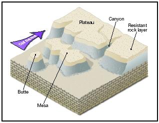
In laymen’s terms, a butte is a small flat-topped or pointed hill or mountain. A mesa is a medium size flat-topped hill or mountain. And a plateau is a really big flat-topped hill or mountain. However, the true definitions are elegant and fascinating and encompass some of the most amazing landscape in the Southwest. Buttes are geologic features up to hundreds of feet high with steep sides, narrow pointed tops or very small flat tops. Buttes are what is left of what was once a mesa; the rest of it has been eroded away. Paria Canyon contains the spectacular Coyote Buttes Special Management Area. The notorious sandstone buttes (North and South Coyote Buttes) sit at the bottom of Utah’s Grand Staircase-Escalante National Monument and the upper section of Arizona’s Paria Canyon-Vermillion Cliffs Wilderness. The buttes and surrounding canyons contain a unique feature called The Wave, a multi-colored chute that has been cut into a sandstone mountain.
A mesa started life as a flat plain. Rivers and streams have eroded away the surrounding area, leaving a flat-topped mountain. Typically, mesas have much larger tops that a butte, and many feel that a mesa can only be called that if standing water can sometimes be found. The Grand Mesa is an outstanding example of this kind of feature. The Colorado River shaped the canyons to the north of the mesa, while the Gunnison River shaped the south side, leaving a large flat-topped mesa in between. The surface area of Grand Mesa covers more than 500 square miles.
The definition difference between a butte and a mesa most likely originated right here in the Southwest. Early settlers said that if you could find game on top, it was a mesa. Eventually that definition translated to the idea that if you could graze cattle (and find water) it was a mesa, not a butte.
A plateau is an area of land that with a relatively level surface raised sharply above the adjacent terrain on at least one side and the surface area of the top of the mesa can be huge. For example, the Colorado Plateau covers portions of southeastern Utah, northern Arizona, northwestern New Mexico and western Colorado. It covers more than 130,000 square miles (only four states in the U.S. cover a larger area). When the rest of the western United States began to rise or uplift some 10 million years ago due to continental drift, the Colorado Plateau region remained stable – perhaps “floating” on a cushion of molten rock. Though ringed by volcanic features, very few volcanoes, managed to penetrate into the interior of the plateau.
Short Version Mesa (Portuguese and Spanish for table) is the American English term for tableland, an elevated area of land with a flat top and sides that are usually steep cliffs. It takes its name from its characteristic table-top shape. It may also be called a table hill, table-topped hill or table mountain. It is larger than a butte, which it otherwise resembles closely.
It is a characteristic landform of arid environments, particularly the Western and Southwestern United States in badlands and mountainous regions ranging from Washington and California to the Dakotas and Texas. Examples are also found in many other nations including Spain, Sardinia, North and South Africa, Arabia, India, and Australia.
A butte /bjuːt/ is an isolated hill with steep, often vertical sides and a small, relatively flat top; buttes are smaller than mesas, plateaus, and table landforms. The word butte comes from a French word meaning "small hill"; its use is prevalent in the Western United States, including the southwest where "mesa" is also used for the larger landform. Because of their distinctive shapes, buttes are frequently landmarks in plains and mountainous areas. In differentiating mesas and buttes, geographers use the rule of thumb that a mesa has a top that is wider than its height, while a butte has a top that is narrower than its height.
To earn credit for this Earthcache, please email me with the answers to these questions. Please do not include answers in your visit log.
- Estimate the Size of the top?
- Estimate the height?
- Is it taller than it is wide?
- Using this information, is this formation a Butte or a Mesa?
References
- Mesa and butte. (2017). Retrieved May 30, 2017, from http://www.scienceclarified.com/landforms/Faults-to-Mountains/Mesa-and-Butte.html
- Davis, George Herbert (1999). Structural Geology of the Colorado Plateau Region of Southern Utah, with Special Emphasis on Deformation Bands. G.S.A. Special Paper 342. Boulder, Colorado: Geological Society of America. p. 30.
- Baker, David M. Morphological Analyses of Mesas and Knobs in the Northwest Fretted Terrain of Mars; Constraints on the Presence and Distribution of Ice-Facilitated Mass-Wasting. Ed. Alexander K. Stewart and James W. Head. Vol. 40. Issue 2. pp. 72. United States: Geological Society of America (GSA) : Boulder, CO, United States, 2008.