This virtual cache is dedicated to the memory of Tony Martin - Fungimanforger - who passed away on 30th June 2019. It was his virtual on the top of Beinn Nibheis (GC7B76V) that gave me the idea for this one, which I acknowledge has been largely plagiarised from his!
It's also my way of thanking him for the amazing Earthcaches he created in the West Midlands and many parts of Scotland (which are now under the care of Baggie Dave). They are truly works of art and erudition
Tony knew I was going to set this virtual based on his but, alas, i seems he never got to see it.
I had to submit it 3 times before the reviewers were happy and it was finally listed on 23rd June while I was away, without email to let Tony know. Sadly he passed away on the 30th June. I did wonder if he managed to see the listing but his last visit to the Geocaching website was 19th June, so sadly it appears not. sadly it appears not
All this has made me very sad: his earthcaches were works of art and, as his last email to me shows, he was a gentleman and a battler.
The geocaching community is a sadder place for his passing. R.I.P. Fungimanforager
If you would like to read more about this and the emails we exchanged see my 'note' of 08/Jul/2019.
Cairngorm, at 4,084 feet is the 6th highest mountain in the UK and, although it is classed as a Munro, Murdo, Hump, Simm and Yeoman, it is one of only 75 Munros that is not a Marilyn.
Because there is only a 145.8m drop to the south west before the ground starts to climb up to the summit of Ben Macdui it is only a sub-Marilyn!
Be that as it may, observations have shown that this mountain top possibly has the most severe climate of anywhere in the UK, worse even than Ben Nevis 55 miles (88km) away to the west, where they started making weather observations in 1881.
The summit of Cairngorm at 1245 m.a.s.l. comprises a small stony plateau, the highest point of which is marked with a huge cairn - there is no Ordnance Survey column - and navigation to & from this point is relatively easy, even when there is cloud down, thanks to a well trodden path that climbs directly up from the restaurant at the top of the railway.
Note, however, if the railway is running and you use it, you may not be allowed to visit the summit and so will be unable to claim this virtual!! (see below in the section about the railway)
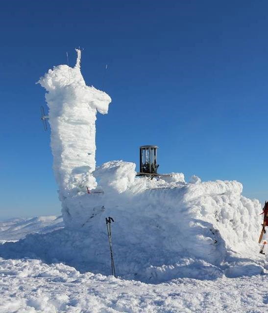
THE AUTOMATIC WEATHER STATION
Close to GZ is an Automatic Weather Station, set up by Heriot-Watt University in 1977, which sometimes startles visitors as it eerily springs to life unannounced.
The photo below shows what it looked like in January 1981
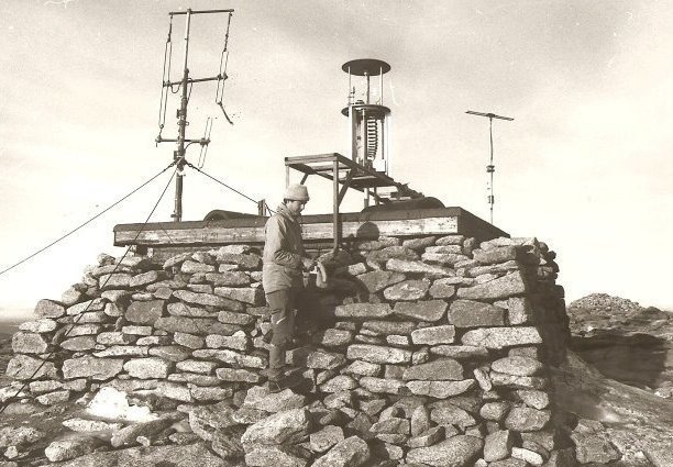
To combat the effects of heavy icing the instruments are housed in a heated cylinder and only emerge from this to sample the weather for 3 minutes every half hour.
The 48 sets of readings taken every day are transmitted in real time by VHF telemetry for use at Glenmore Lodge and data is also transmitted at regular intervals via GSM modem for display on the website: “https://cairngormweather.eps.hw.ac.uk/index.htm"
It is thanks to this data that Cairngorm is officially the "windiest place in Britain" for the highest recorded windspeed in the UK, 176 mph, occurred here at 1148am on the 3rd Jan 1993 and the monthly average windspeeds between 1990 & 1995 were between 25 - 43 miles per hour.
Freezing temperatures can be experienced at any time of the year and the monthly average temperature is below freezing for 7 months of the year; only in July and August does the average monthly rise above 5 degrees C.
The Met Office weather station only publishes temperature and frost data which show that Cairngorm averages 194.4 frost days a year, although unlike most tundra-like climates, the yearly mean temperature at Cairngorm is actually above freezing.
A LITTLE GEOLOGY
Most of the Cairngorms is basically an eroded granite pluton. That is a mass of molten magma that cooled and solidified into rock deep down in the ground. Evidence suggests that the granite currently at the surface was initially to be found at a depth of between 4 and 7km. The main Cairngorm granite pluton formed around 427 million years ago and it is thought that it was 'unroofed' within 20 million years of its emplacement. Thus the present landscape of the Cairngorms had begun to form by 390 million years ago.
The ice ages of the last 2.5 million years have however left their mark both in terms of erosional and depositional features. Post-glacial features include peat and landslips.
THE FUNICULAR RAILWAY
A mountain railway was opened in late 2001 to serve the local ski slopes and, although it is the highest railway in the UK, I suggest you do not use it if you want to log this Virtual as people arriving by train are not allowed allowed outside the top station.
For those interested in railways, the track is 1,970 m (6,460 ft) long and 2.0 m (6 ft 6 3⁄4 in) gauge. The funicular runs from a base station at 637 m up to the top station, situated at 1097 m, only 150 m from the summit of Cairngorm.
It replaced the White Lady Chairlift which was constructed in 1961 but was too sensitive to the strong winds and frequently had to be shut down. Nevertheless, the railway was built amidst some controversy, with supporters of the scheme claiming that it would bring valuable tourist income into the area, whilst opponents argued that such a development was unsuitable for a supposedly protected area and might cause accidents by encouraging poorly equipped and unfit tourists to venture onto a high exposed plateau.
A condition was therefore imposed under which walkers were not allowed outside the top station if arriving by funicular, although this did not apply to skiers and snowboarders in the winter.
In 2010 the operating company proposed to modify this requirement to allow guided walks, whilst still preventing general access and, as of 2017, guided walks are the only way for walkers & summer visitors to access the mountain if arriving via the funicular.
However, the future is uncertain as in November 2018 the railway was placed into administration as it had become "unsustainably loss-making", in spite of the fact that at peak times there could be 150,000–160,000 non-winter sports visitors, combined with a further 50,000–120,000 annual sports visitors during the winter season, and around 1,000 visitors per day during the summer months.
DEDICATION
I would also like to dedicate my 'special' virtual' to all the geocachers that have visited my caches spread far & wide from Spitzbergen to the Antarctic and from California to Tibet, for the pleasure that reading their logs, often very appreciative, has given me. Often this has felt better than finding a cache myself.
Finally, to the conscientious souls who have helped with a little maintenance on my physical caches - the "White Knights of the Geocaching Community" as I like to call them - I say THANK YOU ALL VERY MUCH INDEED.
LOGGING TASKS
To claim this virtual, you must take a picture of the yourself or your GPS at the weather station. Your face, however photogenic, or not, is not mandatory! The back of it will do, it may even be the best view for all I know? Your feet, hands or GPS on the side of the weather station will suffice.
I'm sorry but, as this is a virtual cache, logs without the required photograph will have to be deleted. A PHOTO and / or PHONE/GPS screenshots at GZ are MANDATORY - No Pictures - No LOG.
You should also send me a message via the geocaching site, or an email, telling me
1) What criteria make a mountain a "MARILYN"? and
2) Tell me the name of the department at Heriot-Watt that set up the weather station. This is on the sign which will hopefully be clear of ice and snow at the summit and is '6 words : 1 WORD' and
3) What feature can you see (possibly this will be a virtual sighting) approximately 4 km to the north east of the summit?
4) PLEASE COULD YOU ALSO INCLUDE IN YOUR LOG a record of what you estimate the following to be when you visited the summit:
a) WINDSPEED - Use the Beaufort Scale as an aid.
b) TEMPERATURE - You could obtain the temp at sea level from a current forecast then research “Lapse Rate” at home etc to work out the summit temperature. Average decrease in temp = 2.5 degrees per 1000ft.
c) WINDCHILL FACTOR - Using windspeed and temperature, use research and give the windchill factor on the summit.
d) WIND DIRECTION - Remember that means where its coming from.
e) CLOUD COVER - in octares, 8 octares = full cloud cover.
f) VISIBILITY - in mts/km’s
INCLUDING THIS INFORMATION IN YOUR LOG WILL ENABLE A COMPARISON WITH THE WEATHER EXPERIENCED BY FOLK CLAIMING GREAT BRITAIN'S HIGHEST VIRTUAL ON BEN NEVIS. PHOTO's OF COURSE HELP AUTHENTICATE YOUR FINDINGS.
VIRTUAL REWARDS 2.0 - 2019/2020
This Virtual Cache is part of a limited release of Virtuals created between June 4, 2019 and June 4, 2020. Only 4,000 cache owners were given the opportunity to hide a Virtual Cache. Learn more about Virtual Rewards 2.0 on the Geocaching Blog.The first modern-day release of the opportunity to create Virtual Caches went to 4,000 cache owners who had to create theirs between August 24, 2017 and August 24, 2018.