Norwegian:
Fakta
Lengde: 2-3 timer tur-retur
Passer for: Familietur
Parkering: God parkering
Verdt å merke seg:
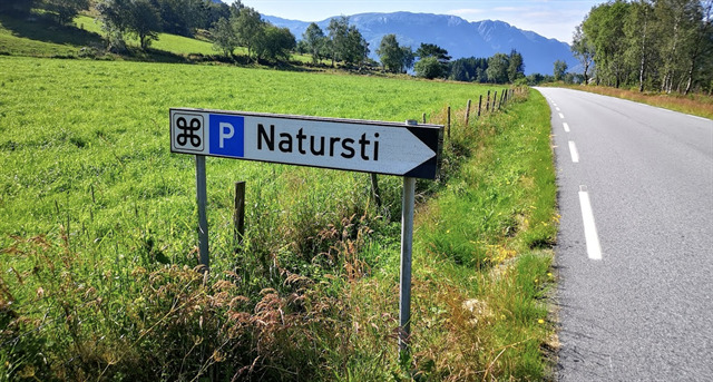
Første del av turen er en del av en natursti. Denne delen er gruslagt skogvei. Turen har mange flotte utsiktspunkt, så husk å ta med kamera.
Om turen:
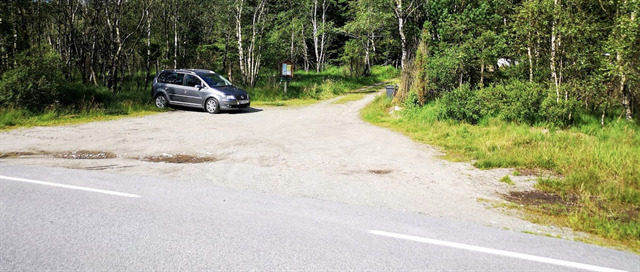
På Rossavikheia er en stor, godt merket parkeringsplass.
Herfra går turen på skogsvei opp i åpen og fin furuskog.
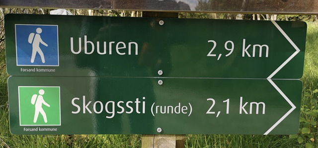
I starten er den trivelig natursti og flere små opplysende skilt som gir spennende informasjon om vilt, skogen og dynamikken i naturen.
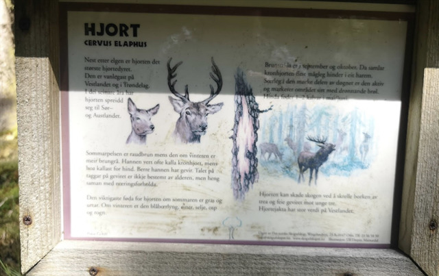
Over furuskogen finnes et varierende innslag av treslag som gran, lerk, bjørk og rogn. Disse danner en fin mosaikk som bidrar til et rikt fugleliv. I tillegg er rådyr og rev vanlig her oppe.
Stien opp gjennom skogen kan virke noe bratt, men den er lett å gå. Utsikten som møter en på det første platået er verdt noen dråper svette. Ved den krokete furuen har en fantastisk utstikt innover til Frafjord i sør.
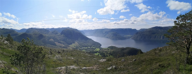
Videre går stien over lett kupert terreng inn under kraftlinjene som strekker seg utover Høgsfjorden.
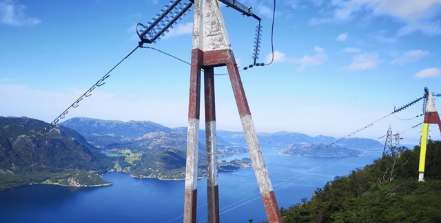
Dette er overføringslinjer fra Lysebotn til Sandnes.
Fra toppen av Uburen kan en på fine dager se helt til Stavanger, Kvitsøy og Karmøy, og da med Forsand, Oanes og munningen til Lysefjorden i forgrunnen.
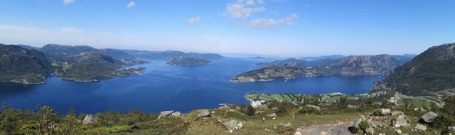
Mot Rossvik kan du se Rosså-hesten i fjellsiden.
Historie og natur
Uburen med sine 440 meter over havet et landemerke ved innløpet til Lysefjorden. Et gammelt sagn kan fortelle at uønsket barn ble frakta opp på fjellet og kasta fra stupet. De ble sagt å være “utborne” og navnet Uburen sies å ha kommet av dette.
Den bratte lia på nordsiden av fjellet er dominert av blokkrik, fattig og moserik bjørkeskog. Her finnes den eneste lokaliteten i Norge av to svært sjeldne vestlige levermoser i tillegg til flere arter av lav som er oppført i den norske rødlisten av truet plante- og dyrearter.
For å logge den virtuelle cachen:
Når du/dere har ankommet nullpunktet kan dere enten ta en selfie med deg og/eller hele teamet ditt mot ferjesambandet Oanes-Lauvik eller et bilde av fingen deres mot ferja. Når bildet blir tatt ha da pekefinger like under fergen, eksempel:
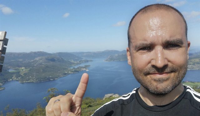
Er tåke den dagen eller du ikke finner ferjen er det greit å bare se veldig forvirret ut om hvor fergen befinner seg eller ta et bilde av en forvirret hånd med skiltet i bakgrunnen.
Lykke til og god tur!
English
Facts
Length: 2-3 hours round trip
Fits for: Family trip
Parking: Good parking
Worth noting:
The first part of the tour is part of a nature trail. This part is a gravel road. The trip has many great viewpoints, so be sure to bring your camera.
About the trip:
At Rossavikheia is a large, well-marked parking lot.
From here, the walk on the forest road goes up into open and nice pine forests.
In the beginning is the pleasant nature trail and several small enlightening signs that provide exciting information about wildlife, the forest and the dynamics of nature.
Above the pine forest there is a varying element of wood species such as spruce, larch, birch and roe. These form a fine mosaic that contributes to a rich bird life. In addition, deer and reef are common up here.
The path up through the forest may seem somewhat steep, but it is easy to walk. The view that meets one on the first plateau is worth a few drops of sweat. At the crooked pine, there is a fantastic view inwards to Frafjord in the south.
Furthermore, the path passes over slightly hilly terrain under the power lines that extend beyond the Høgsfjord.
These are transmission lines from Lysebotn to Sandnes.
From the top of the Uburen you can see all the way to Stavanger, Kvitsøy and Karmøy, and then with Forsand, Oanes and the mouth of the Lysefjord in the foreground.
Against Rossvik you can see the Rosså horse on the mountainside.
History and nature
Uburen with its 440 meters above sea level a landmark at the entrance to the Lysefjord. An old legend can tell that unwanted children were transported up the mountain and tossed off the cliff. They were said to be "bored" and the name Uburen is said to have come off this.
The steep hill on the north side of the mountain is dominated by block-rich, poor and moseric birch forests. Here is the only locality in Norway of two very rare western liver moths in addition to several species of lichen that are listed in the Norwegian Red List of endangered plant and animal species.
To log the virtual cache:
When you / you have arrived at the zero point you can take a selfie with you and/or your entire team and/or just your finger against the ferry connection Oanes-Lauvik. When the picture is taken point your index finger just below the ferry like this:
If there should be foggy and the ferry is not visible, it will be okay to just look very confused about where the ferry is or a picture of a confused hand with the sign in the background.
Good luck and have a great trip!
-----------------
Please leave the following text at the bottom of the page, so cache finders understand the Virtual Rewards 2.0 project.
Virtual Rewards 2.0 - 2019/2020
This Virtual Cache is part of a limited release of Virtuals created between June 4, 2019 and June 4, 2020. Only 4,000 cache owners were given the opportunity to hide a Virtual Cache. Learn more about Virtual Rewards 2.0 on the Geocaching Blog.