
In the Footsteps of Edward Thomas.
Edward Thomas (1878 – 1917) was a British poet, novelist and literary critic. He was a prolific writer and wrote over a million words in the reviews he wrote for the Daily Chronicle where he often submitted as many as 15 book reviews a week. During this time he befriended the Welsh tramp poet W. H. Davies and was almost single-handedly responsible for Davies’s successful career.
Thomas and his family moved to Steep near Petersfield in 1906 so that his two children, Merfyn and Bronwen could attend Bedales School nearby. In 1909 they moved to the Red House in Cockshott Lane (which this walk leads past) where Thomas’s younger daughter Myfanwy was born in 1910. Finally the family moved in 1913 to Yew Tree Cottage in Church Lane where most of his poems were written.
Thomas only started writing poetry in 1915 when his friend Robert Frost (the American poet) suggested he do so. Robert Frost’s most famous poem The Road Not Taken was inspired by walks the two had along the byways and footpaths of Steep. It gently mocks Thomas’s lack of decisiveness when they were out walking. The tone of Frost’s poem is often misunderstood, for his intention was to show that it really doesn’t matter where you choose to go. Tragically, Thomas misunderstood it too and interpreted it seriously and personally, for when Frost sent him an advance copy of the poem from America in July 1915, it provided the catalyst for Thomas to enlist even though, being a mature married man, he could have avoided the fighting.
He was killed in action on Easter Monday 1917 at the Battle of Arras. Although he is often classified as a war poet, along with Rupert Brooke and Wilfred Owen, very few of his poems have war as their subject. He really belongs to the long tradition of rural poets which includes John Clare, Matthew Arnold, Thomas Hardy and A. E. Housman.
Thomas left a canon of 140 poems all written in the last two years of his life. Many of them can be directly linked to the landscape around Steep, although perhaps his most famous poem, the extensively anthologised Adlestrop, was written when his train stopped at the Cotswolds station in June 1914.
The late twentieth century has seen a resurgence in interest in Thomas's poems. Poet Laureate Ted Hughes described him as "the father of us all" and in November 1985 he was among 16 Great War poets commemorated on a slate stone unveiled in Westminster Abbey's Poet's Corner.
Claiming the cache as a find.
To claim the cache you will need to answer two questions. Photos of your GPS at the Poet’s Stone in your log would be welcome but are not essential. Send the two answers to me by email or Message Centre. You may log the cache as soon as you have completed the walk although, of course, any logs for which I have not received any communication after a reasonable period of time may be deleted.
You are quite welcome to tackle the walk as a group but each log must have separate communications for the answers (i.e. no saying in the log, “Cacher X sent in the answers for the whole group”!!). I hope you enjoy the walk and are encouraged to read some of the poet’s work, most of which is freely available online.
Other caches:
Several of the Steep Marsh series set by PetersfieldPoodlePosse lie along the route and Steep has a Church Micro and a “Fine Pair”. There is also a puzzle cache “Hanger On” based on the Poet’s Stone.
The walk
The walk is just over 4.25 miles in length and its elevation rises from 285ft above sea level at its lowest point to 787 feet above sea level at its highest. Some of the paths can be very slippery after rain, especially the final section coming down the Shoulder of Mutton hill, so appropriate footwear needs to be worn and walking poles or walking sticks might be advisable. There is some parking available along Church Road in Steep but please park with consideration for local residents. The given parking waypoint is for the village church.
1. From the church walk across the playing field opposite and then follow the footpath downhill through woodland to a rusty iron kissing gate. At the bottom, bear left along the edge of the field. (Beware: At the time of writing there was a low electric fence to the right along the path here). Carry on around the field edge until you arrive at another kissing gate which leads out to Mill Lane at N51° 01.603' W000° 56.598' (Waypoint 1)
2. Walk up Island Farm Lane passing Mill Meadow Farm on the right until you arrive at a T-junction at N51° 01.694' W000° 56.953' (Waypoint 2). Turn right here and carry on along the sunken lane, tree-lined and with ferns along the high banks.
3. When the lane turns right at N51° 01.893' W0° 56.993' (Waypoint 3) turn left onto the Hangers Way. The Ashford Stream runs alongside the path here and is astonishingly clear. Carry on past Lutcombe Pond the waters of which are also crystal clear.
4. The track climbs leaving the stream far below. At N51° 02.021' W0° 57.331' (Waypoint 4) look down to see the fragments of red brick in the path, evidence that there used to be a ruined cottage nearby. In his poem A Tale Thomas recalls when he walked along here:
There once the walls
Of the ruined cottage stood
The periwinkle crawls
With flowers in its hair into the wood.
5. A little further along at N51° 02.041' W0° 57.392' (Waypoint 5) keep left when a steep bridle way, signposted Hangers Way, enters from the right. The path climbs steadily with a drop on the left down to Lutcombe Bottom past mature yew trees. The poet recalled this location in his poem The Path:
Running along a bank, a parapet
That saves from the precipitous wood below
The level road, there is a path. It serves
Children for looking down the long smooth steep,
Between the legs of beech and yew...
6. At the top of the path at N51° 02.057' W0° 57.685' (Waypoint 6), turn right onto Cockshott Lane. There is no need to venture out onto the very busy Stoner Hill road as the landowner has kindly provided a short cut at this point (although it is not technically a right of way)
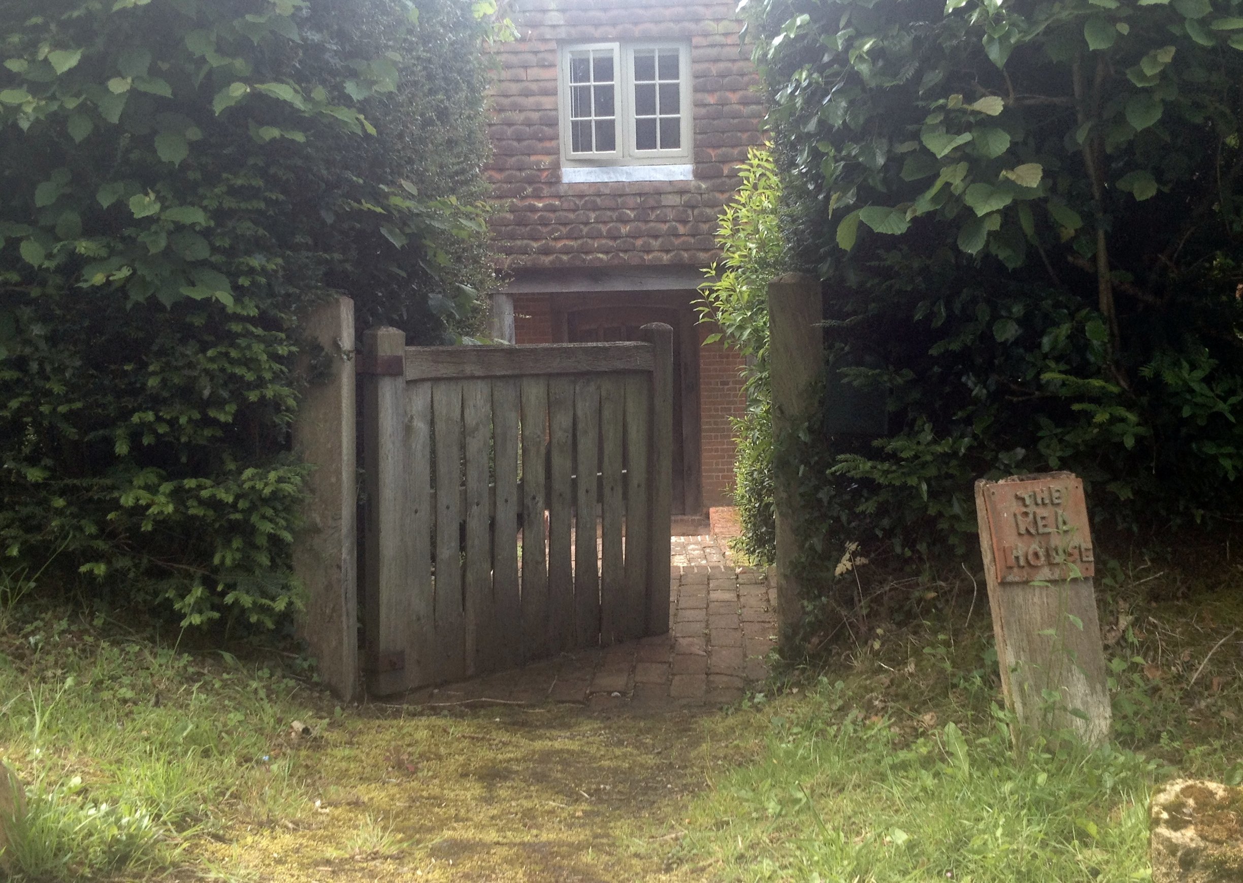
7. Carry on walking along Cockshott Lane to the north east, past the workshops of a furniture designer. The third house on the right is the Red House at N51° 02.129' W0° 57.454' (Waypoint 7) where Thomas and his family lived from 1909-1913. (The house is private property so please respect the privacy of the owner.) Thomas, who was notoriously hard to please, disliked living here. He wrote about the house in his poem The New House:
Now first, as I shut the door,
I was alone
In the new house; and the wind
Began to moan.
Old at once was the house,
And I was old;
My ears were teased with the dread
Of what was foretold…
This first question can be answered from the lane.
QUESTION 1: How many chimney stacks does the Red House have (count the stacks – not the number of pots)
8. Carry on along the lane, which gradually becomes a track, until Old Litten Lane enters on the left. Keep going until you arrive at a “Hangers Way” signpost at N51° 02.282' W0° 56.943' (Waypoint 8).
The signpost here has two arms with “Hangers Way” on each arm. One of the arms also has another two words and the other arm has another three words.
QUESTION 2: What are the five words (not including “Hangers Way”).
9. Turn right by the signpost and carry on, with care, down the hillside until you reach the Poet’s Stone at N51° 02.187' W0° 56.838' (Waypoint 9). The stone is a sarsen stone from Avebury and was dedicated in 1937.
If you like you may post a photo of the Poet’s Stone with either your GPS visible or part of your arm (that is, if you use your phone as camera and GPS), although this is not a logging requirement. Of course, there is nothing to stop you posting a selfie at the stone if you’d like to!
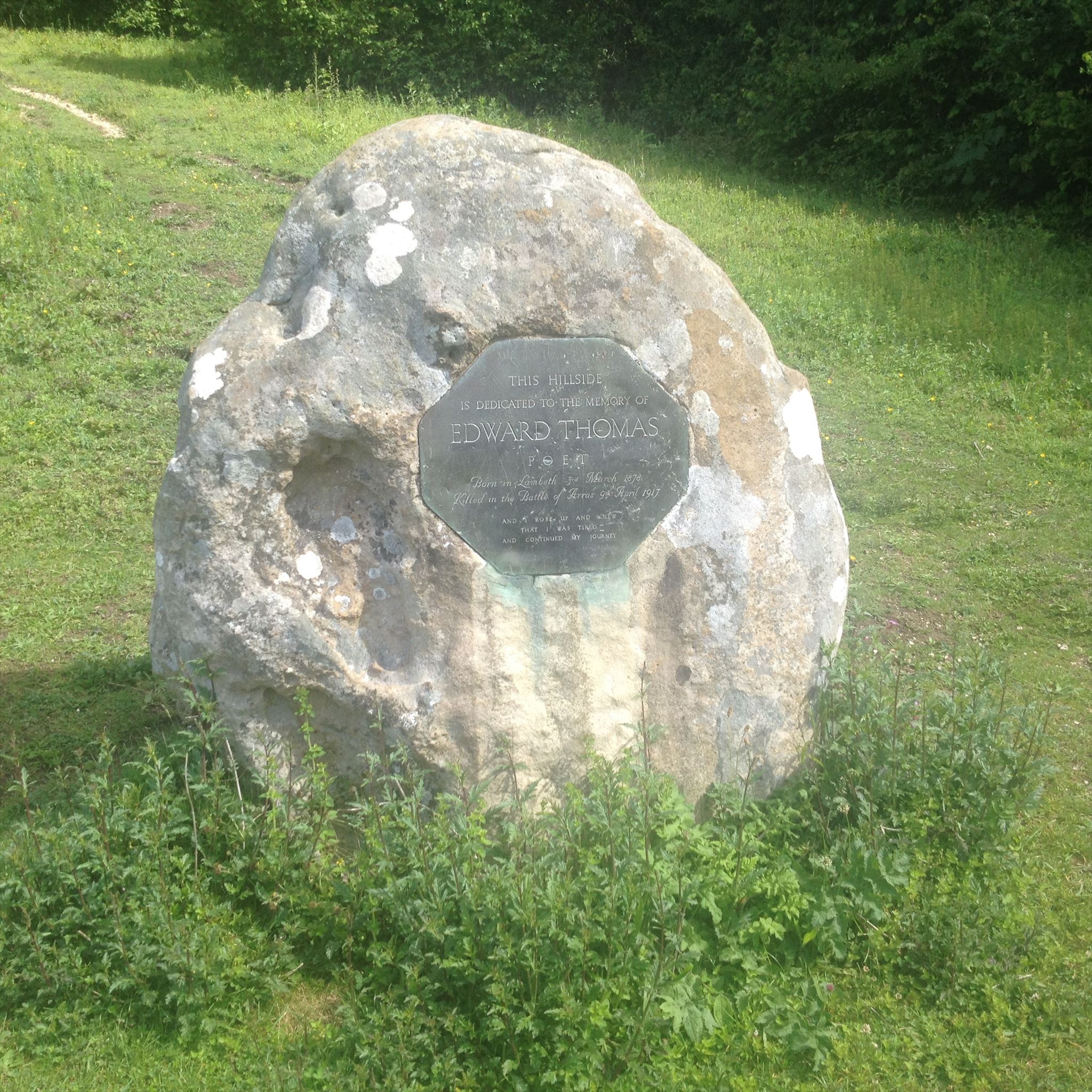
There is a bench at the stone and this is a perfect place to stop and admire the view.
Edward Thomas wrote about this steep slope in his poem When First:
...Fast beat
My heart at sight of the tall slope
Of grass and yews, as if my feet
Only by scaling its steps of chalk
Would see something no other hill
Ever disclosed.
It is recorded that Thomas often would “run down here with Myfanwy [his younger daughter] on his shoulders. She used to whoop with joy."
10. Carry on down the hill, taking great care as the exposed chalk can be very slippery when wet (as the CO knows to his cost!). After descending a flight of steps cut into the hillside, follow the field edge until you arrive at a lane at N51° 01.993' W0° 56.743' (Waypoint 10). Turn right on this lane and then after a few yards, turn left on to the signposted Hangers Way.
11. Follow the tarmac road until you arrive at a private gate at N51° 01.894' W0° 56.674 (Waypoint 11). Just before the gate, turn left along a path. This path will eventually turn right and then left before leading along the bottom edge of a sloping meadow.
12 After you pass a bird hide turn right down a narrow path at N51° 01.670' W0° 56.537' (Waypoint 12).
13 Just before the path reaches the road there is a spectacular waterfall on the right at N51° 01.662' W0° 56.565' (Waypoint 13). This was once a mill race but the mill for which it provided the power has long since gone. Thomas wrote about the waterfall in his poem The Mill-Water. Here are the first and final stanzas:
Only the sound remains
Of the old mill;
Gone is the wheel;
On the prone roof and walls the nettle reigns...
Only the idle foam
Of water falling
Changelessly calling,
Where once men had a work-place and a home.
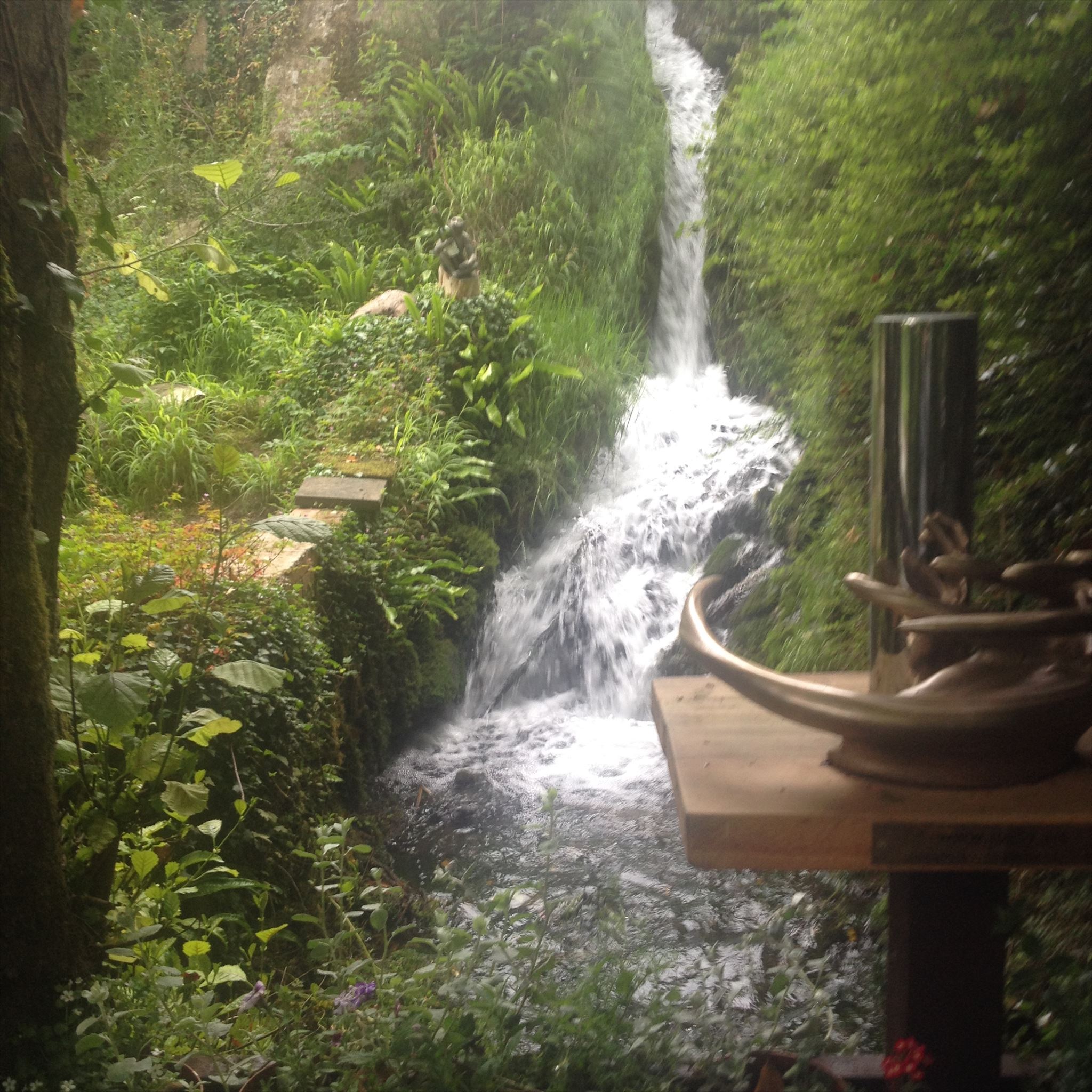
There is a fascinating anamorphic sculpture here created by Jonty Hurwitz: the sculpture doesn’t make sense until you see its reflection in the transparent pillar.
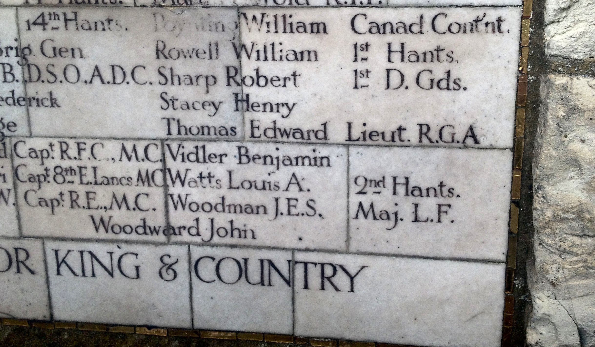
14. After admiring the waterfall and the sculpture, turn right on to Mill Lane and carry on along the lane, past the kissing gate where you emerged at waypoint 2, until you arrive at the Steep village war memorial at N51° 01.393' W0° 56.731' (Waypoint 14). Edward Thomas is recorded on the memorial as “Thomas, Edward Lieut RGA” [2nd Lieutenant Royal Garrison Artillery].
Before leaving, take some time to visit the church which has a pair of engraved lancet windows dedicated to Edward Thomas and some relevant leaflets to read or buy.
This Virtual Cache is part of a limited release of Virtuals created between June 4, 2019 and June 4, 2020. Only 4,000 cache owners were given the opportunity to hide a Virtual Cache. Learn more about Virtual Rewards 2.0 on the Geocaching Blog.