Le Phare du Cap-Ferret
Le premier phare du Cap-Ferret a été envisagé dès 1792. Il ne fut construit que tardivement et mis en service en 1840. C'était une tour de 47,7 m pour une élévation de 51 m. L'électrification eut lieu dès 1929. En août 1944, avant d'évacuer le Cap-Ferret, les Allemands le firent sauter.
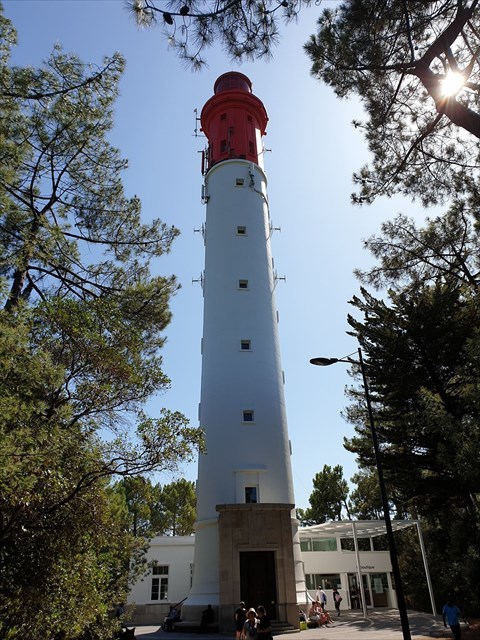
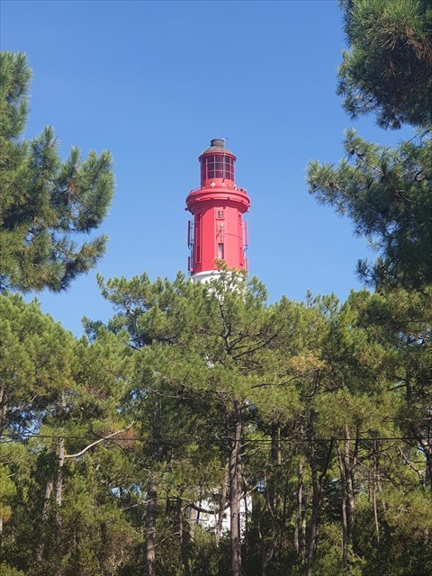
Un deuxième phare a été rebâti rapidement et mis en service en 1947 à la pointe de la presqu’île. L'inauguration eut lieu le 7 août 1949. Le nouveau phare reprend les plans de l'ancien. La tour est de 52,1 m pour une élévation de 62 m avec un feu à éclats rouges toutes les 5 secondes. La porte d'entrée, en avant-corps, est surmontée d'un fronton reprenant les millésimes des mises en service (1840 et 1947) encadrant un bas-relief représentant un navire voguant sur la mer, où figure un poisson et surmontée de l'étoile symbolisant le phare. Le hall d’accueil comporte une mosaïque du maître verrier Auguste Labouret (1871-1964) représentant le Bassin d'Arcachon et la presqu'île du Cap Ferret, ainsi que deux bustes : celui de l'ingénieur hydrographe Beautemps-Beaupré (1766-1854) et du physicien Fresnel (1788-1827), inventeur des lentilles du même nom.
Le phare est ouvert à la visite. Un escalier de 258 marches donne accès au sommet, d'où l'on découvre un panorama très étendu sur la presqu'île, le bassin d'Arcachon, les passes et l'océan.
Une exposition dans une salle annexe présente l'évolution de la topographie du bassin d'Arcachon et de ses abords : cartes marines, instruments de navigation.
Pour logguer le found-it , il va falloir monter ces 258 marches ! Attention l'entrée est payante et aux horaires et jours d'ouverture => Periode et heure d'ouverture
donc ,une fois en haut ,tout le tour du phare vous avez des panneaux rouges qui représente des degrés.
1 -) sur quelle plaque se nomme "Relief Les courbes de " (Nombre à 3 chiffres)
2 -) et maintenant l'inverse qu'elle est le titre de la plaque 10° (4 mots)
3 -) Obligatoire : Faites une photo de votre pseudo (inscrit sur votre main,Papier par exemple) en haut du phare avec la dune du Pilat en arrière-plan.Ajouter cette photo à votre log .
M'envoyer vos réponses par message ou mail .
Remarque : Tout log ne respectant pas ces conditions sera supprimé immédiatement
NE PAS METTRE LES REPONSES AUX QUESTIONS DANS VOTRE LOG !!!!!!!
The Cap-Ferret Lighthouse
 The first lighthouse at Cap-Ferret was considered as early as 1792. It was built only late and put into operation in 1840. It was a 47.7 m tower with a rise of 51 m. The electrification took place in 1929. In August 1944, before evacuating Cap-Ferret, the Germans blew it up.
A second lighthouse was rebuilt quickly and commissioned in 1947 at the tip of the peninsula. The inauguration took place August 7, 1949. The new lighthouse takes the plans of the former. The tower is 52.1m for a rise of 62m with a red flash every 5 seconds. The front door, in front, is surmounted by a pediment showing the years of commissioning (1840 and 1947) framing a bas-relief depicting a ship sailing on the sea, where there is a fish and surmounted by the star symbolizing the lighthouse. The foyer includes a mosaic of the master glassmaker Auguste Labouret (1871-1964) representing the Arcachon Basin and the peninsula of Cap Ferret, as well as two busts: that of the hydrographer Beautemps-Beaupré (1766- 1854) and the physicist Fresnel (1788-1827), inventor of the lenses of the same name.
The lighthouse is open to visitors. A staircase of 258 steps gives access to the summit, from where one discovers a very extensive panorama on the peninsula, the basin of Arcachon, the passes and the ocean.
An exhibition in an annex room presents the evolution of the topography of the Arcachon basin and its surroundings: nautical charts, navigational instruments.
To log the found-it, we will have to climb these 258 steps!
Warning the entry is paying and opening hours and days => Period and opening hours
So, once up, all around the lighthouse you have red signs that represent degrees.
1 -) On which plate is called "Relief Curves of " (3 digit number)
2 -) And maintaining the opposite that it is the title of the 10 ° plate (4 words)
3 -) Compulsory: Make a photo of your nickname (written on your hand, Paper for example) at the top of the lighthouse with the dune Pilat in the background.Add this photo to your log.
Send me your answers by message or email.
Note: Any log that does not meet these conditions will be deleted immediately.
DO NOT PUT THE ANSWERS TO THE QUESTIONS IN YOUR LOG !!!!!!!