 [PL]
[PL]Południk geograficzny to umowna linia o kształcie zbliżonym do półokręgu, która łączy oba bieguny. Długość południka wynosi ok. 20 tysięcy km. Za Południk Początkowy (Zerowy) przyjęto w 1884 roku południk przechodzący przez obserwatorium w londyńskim Greenwich. Płaszczyzna południka 0° i 180° dzieli kulę ziemską na dwie półkule – wschodnią i zachodnią.
Przez Polskę przebiega 10 południków. Jeden z nich prowadzi przez samo centrum Bydgoszczy, a dokładniej to przechodzi niemal przez środek Starego Rynku. Jest to Południk 18°E, który przecina także takie miasta jak Sztokholm (Szwecja), Trenczyn (Słowacja), Dubrownik (Chorwacja) czy też Kapsztad (Republika Południowej Afryki). W Bydgoszczy można znaleźć wiele miejsc, w których na różny sposób oznaczono przebieg Południka 18°E.
Stary Rynek:
W 2019 roku na bydgoskim Starym Rynku został wyżłobiony pas, który symbolizuje przebieg Południka 18°E. W płycie rynku została wycięta szczelina obramowana mosiężną oprawą, w której umieszczono ponad 40 świateł LED, dzięki którym Południk 18°E jest podświetlony nocą. Po północnej stronie pasa symbolizującego przebieg Południka 18°E znajduje się „zegar bydgoski”, który pokazuje aktualny czas słoneczny na tym południku. Warto dodać, że godzina według czasu słonecznego w Bydgoszczy różni się od godziny według czasu słonecznego w Warszawie o 12 minut. Podczas gdy Słońce góruje w Bydgoszczy (godz.12:00 czasu słonecznego), w stolicy naszego kraju jest już godzina 12:12 czasu słonecznego.
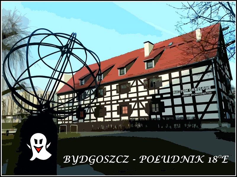
Wyspa Młyńska:
W 1998 roku na Wyspie Młyńskiej został umieszczony obelisk (globus), który wraz z linią wyłożoną kostką brukową także symbolizuje przebieg Południka 18°E. Pomnik ten oddalony jest jednak od prawidłowego Południka 18°E o około 100 metrów. Trzeba jednak dodać, że przebieg tego południka wskazano wówczas prawidłowo. Południk 18°E wyznaczono wtedy z dużą precyzją na podstawie obowiązującej w Polsce mapy zasadniczej według tzw. układu 1965, który oparty był na elipsoidzie Krasowskiego z 1942 roku. Obecnie w Polsce obowiązuje elipsoida GRS-80 zgodna z GPS i powszechnie stosowanym na świecie systemem, co spowodowało przesunięcie siatki południków i równoleżników.
ZADANIA:
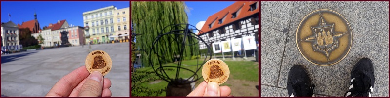
1. STARY RYNEK (Kordy Startowe lub Waypoint 1) – stań na południowym lub północnym krańcu pasa wyżłobionego w płycie Starego Rynku, który symbolizuje przebieg Południa 18°E i zrób zdjęcie siebie lub swojego smartfona / odbiornika GPS / przedmiotu osobistego (np. drewniaka z własnym nickiem) z tym wyżłobionym pasem. Zdjęcie dołącz do swojego wpisu na geocaching.com.
Pamiętaj, żeby w tym miejscu zebrać informacje, które pomogą obliczyć Ci współrzędne Waypointu 3.
A – suma cyfr przy Sztokholmie
B – suma cyfr przy Kapsztadzie
2. WYSPA MŁYŃSKA (Waypoint 2) - zrób zdjęcie siebie lub swojego smartfona / odbiornika GPS / przedmiotu osobistego (np. drewniaka z własnym nickiem) z obeliskiem (globusem) symbolizującym przebieg Południka 18°E wg układu 1965. Zdjęcie dołącz do swojego wpisu na geocaching.com.
Pamiętaj, żeby w tym miejscu zebrać informacje, które pomogą obliczyć Ci współrzędne Waypointu 3.
C – liczba liter w nazwisku astronoma i geodety, którego pomiary pozwoliły w 1998 roku wytyczyć w tym miejscu przebieg Południka 18°E
D – liczba w nazwie modelu siatki, według której przebieg Południka 18°E wytyczono na Starym Rynku
3. HERB BYDGOSZCZY 18°E (Waypoint 3) – zrób zdjęcie siebie lub swojego smartfona / odbiornika GPS / przedmiotu osobistego (np. drewniaka z własnym nickiem) z herbem Bydgoszczy symbolizującym przebieg Południka 18°E, który został wmontowany w chodnik na jednej z bydgoskich ulic w obrębie Starego Miasta. Zdjęcie dołącz do swojego wpisu na geocaching.com.
Współrzędne Herbu Bydgoszczy 18°E:
N 53°07 .[(B*C)+D-A+C-1]'
E 018°00.000'
UWAGA: W mieście można znaleźć kilka takich samych herbów, ale zadanie polega na odnalezieniu tego konkretnego herbu (!)
Logi bez załączonych TRZECH odpowiednich zdjęć będą kasowane bez ostrzeżenia. Proszę nie zamieszczać zdjęć zawierających spoilery (!)
Przykładowe zdjęcia dołączane do Twojego wpisu mogą wyglądać tak:
W nagrodę możesz wkleić pamiątkę wirtualną na swoim profilu:
<center><a href="https://www.geocaching.com/geocache/GC891JR_bydgoszcz-poludnik-18e" target=_blank><img src="https://i.ibb.co/2Fm58d6/Souvenir-Bydgoszcz-Po-udnik-18.jpg"></a></center>
 [EN]
[EN]A geographic meridian is the half of an imaginary great circle on the Earth's surface and it passes through the North Pole to the South Pole. The length of a meridian is 20,000 kilometers. The meridian through Greenwich (London, England) called the Prime Meridian, was set at zero degrees of longitude in 1884. The plane of the meridian at 0° and 180° divides the Earth into two hemispheres – Eastern and Western.
There are 10 meridians passing through Poland. One of them passes through the Old Market square in the city center of Bydgoszcz. This is the Meridian of 18°E, which also passes through Stockholm (Sweden), Trenčín (Slovakia), Dubrovnik (Croatia) or Cape Town (South Africa). You can find many places in Bydgoszcz where the Meridian of 18°E is marked.
The Old Square:
A brassy belt has been curved in the surface of the Bydgoszcz Old Market square in 2019. This belt symbolizes location of the Meridian of 18°E. It has more than 40 LED lights, so the belt is floodlit at night. The “Bydgoszcz Clock” is situated in the northern edge of the belt. It shows the solar time in Bydgoszcz. According to this clock, the time between Bydgoszcz and Warsaw differs about 12 minutes. When there is a noon in Bydgoszcz, at the same moment is 12:12 pm in Warsaw according to the solar time.
The Mill Island:
The obelisk (globe) and the line made of sett has been placed on the Mill Island in 1998. It symbolizes location of the Meridian of 18°E according to the old basic map so-called the 1965 Datum which was based on the ellipsoid of Krasowski from 1942. This obelisk is situated about 100 meters from the true Meridian of 18°E which was demarcated according the ellipsoid GRS-80 compatible with GPS and present World Geodetic System.
TASKS:
1. THE OLD MARKET SQUARE (Start Coordinates or Waypoint 1) – go to the southern or northern edge of the curved belt which symbolizes the Meridian of 18°E and take a photo of yourself or your smartphone / GPS device / personal item (e.g. woodcoin with your nickname) with this curved belt. Add the photo to your log in geocaching.com.
Remember to collect here all information necessary for calculating of coordinates of the Waypoint 3.
A – sum of numbers next to Stockholm
B – sum of numbers next to Cape Town
2. THE MILL ISLAND (Waypoint 2) - take a photo of yourself or your smartphone / GPS device / personal item (e.g. woodcoin with your nickname) with the obelisk (globe). Add the photo to your log in geocaching.com.
Remember to collect here all information necessary for calculating of coordinates of the Waypoint 3.
C – number of letters in the surname of astronomer and geodesist whose measurements allowed to demarcate the Meridian of 18°E here in 1998
D – number in the name of World Geodetic System which demarcated the Meridian of 18°E in the Old Market square
3. THE EMBLEM OF BYDGOSZCZ 18°E (Waypoint 3) – take a photo of yourself or your smartphone / GPS device / personal item (e.g. woodcoin with your nickname) with the emblem of Bydgoszcz which symbolizes the Meridian of 18°E. The emblem of Bydgoszcz has been installed in the pavement, somewhere in the Old Town. Add the photo to your log in geocaching.com.
Coordinates of the emblem of Bydgoszcz 18°E:
N 53°07 .[(B*C)+D-A+C-1]'
E 018°00.000'
NOTICE: There are several similar emblems in the city, but you must find the specific emblem from the task (!)
Logs without THREE correct photos will be deleted. Do not add photo spoilers (!)
Exemplary photos uploaded to your log you can find below:
You can paste the virtual souvenir into your profile:
<center><a href="https://www.geocaching.com/geocache/GC891JR_bydgoszcz-poludnik-18e" target=_blank><img src="https://i.ibb.co/2Fm58d6/Souvenir-Bydgoszcz-Po-udnik-18.jpg"></a></center>
Virtual Rewards 2.0 - 2019/2020
This Virtual Cache is part of a limited release of Virtuals created between June 4, 2019 and June 4, 2020. Only 4,000 cache owners were given the opportunity to hide a Virtual Cache. Learn more about Virtual Rewards 2.0 on the
Geocaching Blog.