
The Tuia Mātauranga GeoTour is about having fun discovering the history of Aotearoa New Zealand by finding sites of significance in local communities from early Pacific voyaging and migration, European settlement to present day. The interaction between people, and people and the land have provided a rich history that the GeoTour invites you to explore.
---
Lieutenant James Cook, while commanding the Endeavour, was instructed to head to Tahiti for the transit Venus, then to sail south to find the Great Southern Continent, then west to find the eastern shore of the new land that Abel Tasman had discovered 130 years earlier. Cook struck New Zealand at Poverty Bay, near Gisborne. From there he sailed north, following and plotting the coast as he went. Rounded North Cape and came south down the west coast of the North Island. He sailed into Marlborough Sounds on 16 January 1770, and anchored at Ship Cove, his first night off the South Island. Over the seven years and three voyages Cook spent 105 days camped in Ship Cove, resting his crew, repairing and restocking his ship. Given that he spent a total of 328 days exploring and surveying the coastline, this demonstrates just how much he thought of the anchorage.
Cook's second voyage to New Zealand, in Resolution with Furneaux in Adventure, was tasked with finding the Great Southern Continent. He used Ship Cove as a base of operations for three voyages south. In each case the Resolution was turned back after meeting pack ice, conclusively proving that the continent did not exist.
Of course, Cook and his crew were not the first to discover the beauty of the Marlborough Sounds. In his own journal he recorded that: "The number of Inhabitants hardly exceeds 3 or 400 people, they leive (sic) dispers'd along the Shores in search of their daly (sic) bread, which is fish and firn (sic) roots for they cultivate no part of the lands". (Journals of Captain Cook, 6 February, 1770). On 22 January he went exploring in the ship's boat but after some 24 kilometres still had not reached the end - Cook never found the bay where Picton now lies. His map shows that he gave this area two names - Charlotte's Sound, after Queen Charlotte, or Cannibal Bay, after seeing that evidence himself. Despite this and the occasional small problem, the crew of the Endeavour got along well with the local inhabitants. Having Tupaia, a Tahitian priest, able to translate made a big difference in handling the cultural differences that caused such a problem for Abel Tasman 130 years earlier.
Māori not only see the sounds as a sheltered waterway and a valued food and trade resource, it also figures prominently in their lore. The Māori name for Queen Charlotte Sound is Totoranui, possibly referring to its many coves as branches of a large totora tree, or as reference to another name, that of Te Tau Ihu o te Waka, the mighty carved prow of Te Waka o Māui, the canoe of Māui, one of the names for the South Island. Still another legend tells of the battle between the legendary explorer Kupe, who faught Te Wheke o Muturangi, a giant octopus, in the Cook Strait. Arapaoa Island is named for the downward blow (pao) of his axe that killed the octopus and the sounds were shaped by the octopus as it grabbed for the land. It was also from this island that Cook verified for himself the existence of a strait separating the North and South Islands.
The hill that this cache stands on is Te Ihu Moemoe, the nose of the sandworm, a taniwha (supernatural being) that was tasked with separating the headland from the mainland and got stuck in the mud.
Whether you explore the Marlborough Sounds, or use it as part of your way of life, the area is amazing and beautiful, wrapped up in a big blue and green mess. From the car park you can see some of that mess, a number of coves visible right here. Enjoy!
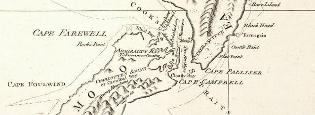
Cook's map of the Marlborough Sounds. Click for a zoomable view.
To be able to complete this Geotour and recieve your special geocoin, remember to take a note of the codeword on the logbook of the cache. This will need to be recorded in your passport which can be downloaded from here. If the passport is unavailable for any reason just keep a note of the codeword and try again later.
The cache background and the birds in the banner are kauka, bar-tailed godwits, chosen by Tuia Mātauranga as they perform the longest non-stop migration of any non-seabird, a single flight from Alaska to New Zealand and Australia.
References:
David Mackay: 'Cook, James', Te Ara - the Encyclopedia of New Zealand, 1990, 2007
www.captaincooksociety/home/detail/shipcove