
El macizo de Peñagolosa presenta importantes aspectos geológicos, tales como la interesante secuencia estratigráfica, representativa de buena parte del período Cretácico , y los notables rasgos estructurales y geomorfológicos. Entre estos últimos destacan formas típicas de periglaciarismo, así como espectaculares formaciones kársticas como el Poljé de Vistabella con su engolidor del Quinyó, el Cañón del río Monleón , el río Carbo y distintas cuevas de interés.
El macizo se ubica en la encrucijada entre ambientes biogeográficos muy diversos. Su carácter de transición entre el interior y la costa, y también entre los sectores norteño y meridional de la Comunidad Valenciana, propicia una extraordinaria diversidad de flora y fauna. Esta riqueza queda acrecentada por la fuerte impronta paisajística de los espesos bosques de las laderas en contraste con los rasos de las cumbres.
W. Cavazz
- PARA PODER LOGUEAR
-
Para poder registrar este Earth Cache como encontrado / visitado debereís cumplir los siguientes requisitos en el orden propuesto:
-
1º Enviar al propietario del cache las respuestas que creeís correctas a las preguntas formuladas a traves del centro de. mensajes de geocaching.com.
-
2º despues de mandarme vuestras respuestas, nunca antes, podeís loguear el Earth como found, nunca al reves
-
3ª si alguna respuesta no fuera correcta, me pondre en contacto con vosotros.
-
.4º se solicita una foto vuestra en el lugar de la tierra para demostrar vuestra presencia, no es obligado un selfi, vastará que en la foto salga vuestro gps, un papel con vuestro nick o vuestra sombra si no quereis salir en la foto, sin foto no hay validacion
-
Todos los registros que no cumplan estas normas seran borrados sin previo aviso.gracias.
-
Gracias de antemano por vuestras visitas
PREGUNTAS A CONTESTAR PARA RESOLVER ESTE EARTH
1) Época de formación de la Cordillera Ibérica
2) altura en metros del Penyagolosa
3) Definir breve mente que es el polje de Vistabella
4) Hace cuantos millones de años comienza la sedimentación sobre el zócalo paleozoico?
5) Despues de pasar por el Portellas, encontraras la senda que te lleva a las coordenadas de cabezéra, busca un enebro bajo un viejo pino, una vez alli podras apreciar claramente los estratos calizos, observa su color, la pregunta es; ¿por que tiene ese color, que marca hay en la roca hecha a mano y como es dicha roca al tacto?
6) Envianos a nuestro correo o por el centro de mensajes las respuestas y si quieres opcionalmente sube una foto tuya o de tu gps a los pies de las vias de escalada desde donde se ven claramente los distintos estratos en la inponénte pared, después de mandarme las respuestas ya puedes registrar el cache, si hay algo mal me pondré en contacto con tigo
Todos los registros que no cumplen los requisitos serán borrados sin previo aviso, gracias.
LA HISTORIA GEOLÓGICA
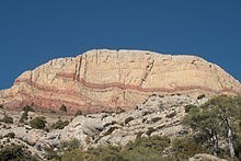
La vertiente sur de Penyagolosa es el marco estructural del sistema ibérico, se ajusta claramente a la evolución típica de una cordillera alpina. Sobre una potente cobertera mesozoica se fueron sucediendo movimientos de comprensión y distensión que acabaron compartimentando el relief. El área que estamos tratando se situar en una de estas partes diferenciadas denominada sector subtabular, caracterizada por ser una amplia meseta calcárea con ondulaciones anticlinales de gran radio y fracturas generalmente normales, lo cual está visiblemente representado por una serie de muelas y altiplanos en las que se encajan barrancos y ríos como el Montlleó. Su historia sedimentaria comienza hace más de 200 millones de años, en la era secundaria, sobre el rígido zócalo paleozoico. A lo largo del mesozoico,
El fondo del mar estuvo habitado por una rica fauna en la que predominaban los moluscos gasterópodos (Natica sp) y pelecípodos (lamilibranquios) (Pecten sp., Ostrea sp., Exogyra sp.), Muestra de esto son los abundantes fósiles de este tipo que nos podemos encontrar en todo el territorio. Roca del Senallo. Sobre el río Montlleó Al finalizar el Cretácico, hace unos 70 millones de años, se origina la emersión definitiva de toda el área, hecho éste relacionado con la Orogenia Alpina. En el Mediterráneo, el acercamiento de la placa africana a la europea fue el responsable de que las capas depositadas en el Mar de Tetis fueron plegadas y fracturadas, elevándose formando cadenas montañosas.
El sector donde nos encontramos, no se vio afectado con tanta intensidad debido a que estaba ubicado en la zona más abierta a la cuenca sedimentaria y en ella el espesor de materiales acumulados era mayor que en los márgenes. De ahí que, ante una misma comprensión, toda la masa de estratos fuera empujada hacia el norte, pero sólo sufriera una deformación importante allí donde era más delgada y por tanto más moldeable. Con posterioridad, hacia la mitad del período Mioceno, alrededor de 15 millones de años atrás, tiene lugar un proceso distensivo, de estiramiento de la corteza terrestre, que fracturará la superficie dando lugar a nuevos accidentes del relieve. Sin embargo, un nuevo proceso erosivo arrasará gran parte de la Península Ibérica hasta mediados del Plioceno, hace unos 5 millones de años, dando como resultado una extensa llanura,
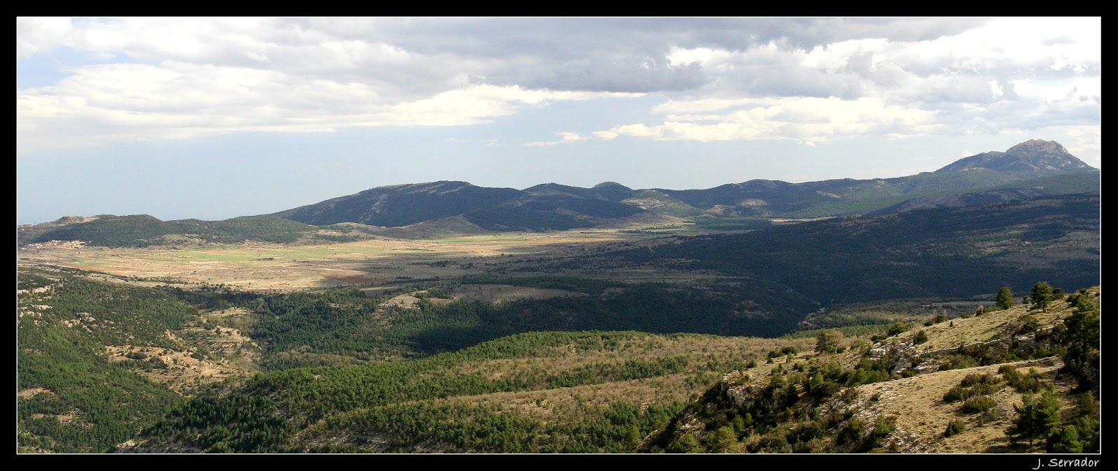
Un ejemplar de este relieve residual es el pico de Penyagolosa, montaña que ya existía durante el Mioceno, cuyos potentes estratos calizos resistieron la erosión a lo largo de 10 millones de años. Entre la mitad del Plioceno y el comienzo del Cuaternario, ocurrió una nueva etapa distensiva decisiva para la configuración del relieve actual, ya que dará lugar a grandes accidentes orográficos como el abombamiento de Gúdar, que elevará la penillanura hasta los dos mil metros, y el conjunto de fallas en graderío que compartimentarán el terreno en su descenso hacia el mar. Finalmente, durante la morfogénesis cuaternaria, esto es, a lo largo de los últimos 600.000 de años, con sus procesos de erosión y sedimentación se acaba determinando el relieve que vemos hoy. Así, como consecuencia de la elevación anterior general del territorio, se originará un dilatado proceso de encajamiento de la red fluvial, dando lugar a los valles y montes actuales. Sin embargo, este proceso tuvo varias fases debido a la alternancia de períodos climáticos del Cuaternario. A las frías glaciaciones le sucedían templadas etapas interglaciares, lo que afectaba a la agresividad de los agentes erosivos, de manera que a épocas de ahondamiento del fondo de los ríos, le seguían otras de acumulación de sedimentos y predominio del desarrollo de glacis. El resultado de esta historia geológica es el montañoso paisaje actual, por momentos escarpado y abrupto, donde predominainan las superficies planas o suavemente inclinadas, incididas profundamente por una red fluvial como el cañón del río Montlleó que en algunos tramos, como ocurre entre Benafigos y Culla , alcanza un desnivel superior a los 500 m.
LOS FENOMENOS CARSTICOS
El Pla de Vistabella (poljé) El área que comprende la cuenca del río Montlleó forma parte del gran sinclinal del Penyagolosa, de orientación ibérica, compartimentada por los esfuerzos distensivos posteriores y afectada por importantes procesos de disolución. Ciertamente, el fuerte predominio de la roca calcárea sometida a una intensa fracturación y con niveles intercalados de arenas, margas y arcillas, con una menor permeabilidad, han favorecido considerablemente la disolución cárstica. Buena parte de los cursos fluviales de este sector drenan lo que parecen haber sido antiguas depresiones con funcionamiento cárstico, ya que conservan, además del lecho actual, varias superficies de aplanamiento por disolución a distintas alturas. Además, existen tramos de poljes funcionales y vestigios de formas cársticas, tales como hums, lapiaces, simas o dolinas. Sumidero de la uvala de Benafigos En una amplia zona, entre Mosqueruela y Benafigos, pueden reconocerse, una serie de depresiones cársticas que constituirían un antiguo sistema de poljes que, en ciertos momentos de su evolución, pudieron estar comunicados algunos de ellos entre sí, pero que luego se individualizaron. Citando los más destacados, se encontrarían algunas cuencas endorreicas actuales como los poljes de Los Castillejos, el Pla de Vistabella y la gran uvala de Benafigos, y poljes capturados por la red fluvial como el de Mosqueruela, el mismo valle del río Montlleó o el Arroyo Majo. Todos ellos suelen tener forma alargada y una orientación concreta, generalmente NE-SO, adaptada a los accidentes tectónicos. Así, los poljes de Mosqueruela, Vistabella y del Montlleó se localizan sobre fosas (grabens) que hunden materiales calizos, mientras que en las vertientes elevadas de los márgenes (horst) afloran arenas y arcillas coronadas por calizas, que actúan como almacén de agua y dan lugar a numerosos manantiales. Polje de Los Castillejos (Puertomingalvo) Este es uno de los factores que ha favorecido la formación de los poljes al suministrar, las aguas superficiales, los materiales que son arrastrados hasta el fondo de la depresión, acelerando la corrosión gracias a la retención del agua. Un ejemplo lo encontramos en el poljé funcional de Los Castillejos, localizado en el extremo meridional del de Mosqueruela, junto a la ermita de San Bernabé. Por otro lado, el cañón del río Montlleó representa un karst en un estado de madurez muy avanzado, cercano a la senilidad..
informacion extraida del articulo: Descubriendo Penyagolosa por José P. Serrador Almudéver
INGLES GOOGLE
The Peñagolosa massif presents important geological aspects, such as the interesting stratigraphic sequence, representative of a good part of the Cretaceous period, and the remarkable structural and geomorphological features. Among the latter, typical forms of periglacialism stand out, as well as spectacular karst formations such as the Poljé de Vistabella with its engolidor del Quinyó, the Monleón River Canyon, the Carbo River and different caves of interest.
The massif is located at the crossroads between very diverse biogeographic environments. Its transitional character between the interior and the coast, and also between the northern and southern sectors of the Valencian Community, favors an extraordinary diversity of flora and fauna. This richness is increased by the strong landscape imprint of the thick forests on the slopes in contrast to the flatness of the peaks.
W. Cavazz
TO BE ABLE TO LOGUE
In order to register this Earth Cache as found / visited, you must meet the following requirements in the proposed order:
1st Send to the owner of the cache the answers that you think are correct to the questions asked through the center. messages from geocaching.com.
2nd after sending me your answers, never before, you can log in the Earth as found, never the other way around
3rd if any answer is not correct, I will contact you.
.4º a photo of you is requested in the place of the earth to demonstrate your presence, a selfie is not required, your gps will appear in the photo, a paper with your nickname or your shadow if you do not want to appear in the photo, without photo no validation
All records that do not meet these standards will be deleted without prior notice. Thank you.
Thanks in advance for your visits
QUESTIONS TO BE ANSWERED TO SOLVE THIS EARTH
1) Period of formation of the Iberian Mountain Range
2) height in meters of the Penyagolosa
3) Briefly define what the Vistabella polje is
4) How many million years ago did sedimentation begin on the Paleozoic base?
5) After passing through the Portellas, you will find the path that takes you to the Cabezéra coordinates, look for a juniper under an old pine, once there you will be able to clearly appreciate the limestone strata, observe its color, the question is; Why does it have that color, what mark is there on the handmade rock and how is said rock to the touch?
6) Send us the answers to our email or through the message center and if you want optionally upload a photo of yourself or your GPS at the foot of the climbing routes from where you can clearly see the different layers in the huge wall, after sending me the answers you can register the cache, if there is something wrong I will contact you
All records that do not meet the requirements will be deleted without prior notice, thank you.
THE GEOLOGICAL HISTORY
The southern slope of Penyagolosa is the structural framework of the Iberian system, it clearly conforms to the typical evolution of an alpine mountain range. On a powerful Mesozoic cover, movements of understanding and relaxation took place that ended up compartmentalizing the relief. The area that we are treating is located in one of these differentiated parts called the subtabular sector, characterized by being a wide calcareous plateau with anticline undulations of great radius and generally normal fractures, which is visibly represented by a series of grinding wheels and plateaus in which ravines and rivers like the Montlleó are embedded. Its sedimentary history begins more than 200 million years ago, in the secondary era, on the rigid Paleozoic base. Throughout the Mesozoic,
The seabed was inhabited by a rich fauna in which gastropod mollusks (Natica sp) and pellecipods (lamilibranchs) (Pecten sp., Ostrea sp., Exogyra sp.) Predominated. Proof of this are the abundant fossils of this type that we can find throughout the territory. Rock of the Senallo. On the Montlleó River At the end of the Cretaceous, about 70 million years ago, the definitive emergence of the entire area began, a fact related to the Alpine Orogeny. In the Mediterranean, the approach of the African plate to the European one was responsible for the layers deposited in the Sea of Tethys being folded and fractured, rising forming mountain ranges.
The sector where we are, was not affected with such intensity because it was located in the area most open to the sedimentary basin and in it the thickness of accumulated materials was greater than in the margins. Hence, under the same understanding, the entire mass of strata was pushed north, but only underwent a significant deformation where it was thinner and therefore more moldable. Later, towards the middle of the Miocene period, around 15 million years ago, a distensive process takes place, stretching the earth's crust, which will fracture the surface, giving rise to new relief accidents. However, a new erosive process will devastate much of the Iberian Peninsula until the middle of the Pliocene, about 5 million years ago, resulting in an extensive plain,
An example of this residual relief is the Penyagolosa peak, a mountain that already existed during the Miocene, whose powerful limestone strata resisted erosion over 10 million years. Between the middle of the Pliocene and the beginning of the Quaternary, a new decisive distensive stage occurred for the configuration of the current relief, since it will give rise to large orographic accidents such as the Gúdar bulge, which will raise the peneplain to two thousand meters, and the set of faults in stands that will compartmentalize the land as it descends towards the sea. Finally, during quaternary morphogenesis, that is, over the last 600,000 years, its erosion and sedimentation processes end up determining the relief we see today. Thus, as a consequence of the previous general elevation of the territory, a long process of embedding of the river network will originate, giving rise to the current valleys and mountains. However, this process had several phases due to the alternating climatic periods of the Quaternary. The cold glaciations were followed by temperate interglacial stages, which affected the aggressiveness of the erosive agents, so that times of deepening of the river bottom were followed by others of accumulation of sediments and the predominance of glacial development. The result of this geological history is the current mountainous landscape, at times steep and abrupt, where flat or gently sloping surfaces predominate, deeply impacted by a fluvial network such as the Montlleó river canyon that in some sections, as occurs between Benafigos and Culla , reaches a slope of more than 500 m.
THE CHARSTIC PHENOMENA
The Pla de Vistabella (poljé) The area that comprises the Montlleó river basin forms part of the great syncline of the Penyagolosa, of Iberian orientation, compartmentalized by subsequent distensive efforts and affected by important dissolution processes. Certainly, the strong predominance of calcareous rock subjected to intense fracturing and with interspersed levels of sands, marls and clays, with lower permeability, have considerably favored karst dissolution. A good part of the river courses in this sector drain what seem to have been ancient depressions with karst functioning, since they preserve, in addition to the current bed, several surfaces of flattening by dissolution at different heights. In addition, there are stretches of functional poljes and vestiges of karst forms, such as hums, lapiaces, chasms or sinkholes. Benafigos grape sink In a wide area, between Mosqueruela and Benafigos, can be recognized, a series of karst depressions that would constitute an ancient poljes system that, at certain moments of its evolution, some of them could be communicated with each other, but that later were individualized. Citing the most prominent, we would find some current endorheic basins such as the poljes of Los Castillejos, the Pla de Vistabella and the great uvala of Benafigos, and poljes captured by the fluvial network such as that of Mosqueruela, the same valley of the Montlleó river or the Arroyo Nice. All of them tend to have an elongated shape and a specific orientation, generally NE-SW, adapted to tectonic accidents. Thus, the Mosqueruela, Vistabella and del Montlleó poljes are located on pits (grabens) that sink limestone materials, while on the raised slopes of the margins (horst) sands and clays topped by limestone emerge, which act as a store of water and they give rise to numerous springs. Polje de Los Castillejos (Puertomingalvo) This is one of the factors that has favored the formation of poljes by supplying, surface water, the materials that are dragged to the bottom of the depression, accelerating corrosion thanks to the retention of water. An example is found in the functional poljé of Los Castillejos, located at the southern end of Mosqueruela, next to the hermitage of San Bernabé. On the other hand, the Montlleó river canyon represents a karst in a very advanced state of maturity, close to senility.
information extracted from the article: Discovering Penyagolosa by José P. Serrador Almudéver