Submit your answers by E-Mail before logging your find.
Logs submitted without emailing an answer will be Deleted.
If you are doing this earth cache as a group, each person logging a find must submit their own answers to each earth cache question.
1. How far back has the cliff eroded from the stumps?
2. Why is the flower pot shorter than the cliff?
3. How tall is the flowerpot?
4. How many layers make up the flowerpot?
5. Stop at the St Martins Sea Caves waypoint after you visit the earthcache. You can see a headland with sea caves forming. Do you think flowerpots will eventually form here?
6. Post a picture in your log with a personal item or hand in picture to prove you were there.
[REQUIRED] In accordance with the updated guidelines from Geocaching Headquarters published in June 2019, photos are now an acceptable logging requirement and WILL BE REQUIRED TO LOG THIS CACHE. Please provide a photo of yourself or a personal item in the picture to prove you visited the site.
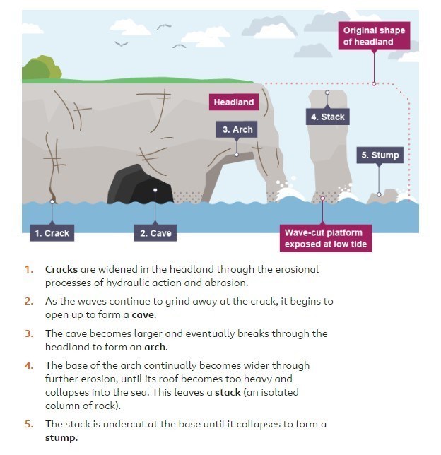
Stacks and stumps are geological features that are commonly found on headlands like the area around the Fundy Trail Flower Pot Rock. These headlands are characterized by breaking waves, rocky shores, intense erosion and steep sea cliffs. The headlands jut out into the water and allow the cliffs to be unprotected on both sides.
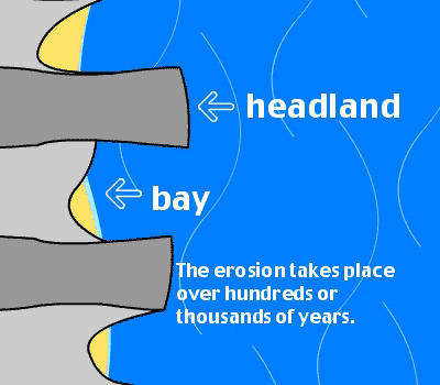
This area around the Bay of Fundy was once a dry rift valley, but after the Ice Age, the valley filled with water, creating a deep tidal bay. Rain and ice continued to erode the cliffs from the top, while the twice daily tidal action wore away at the base of the cliffs and rock.
The red cliffs near St. Martins are composed of Permian-Triassic sandstone and conglomerate, part of the Echo Cove Formation. In later years, during a period of surface plate activity, these layers of conglomerate, sandstone and shale were uplifted and tilted to a 30-45º angle. Vertical cracks or fissures divided the rock into large blocks. Ice and rain caused these fissures in the rocks to widen and erode forming the beginnings of the flowerpot formations.
Tidal action continued to erode the soft sandstone along the shoreline. Surface water, filtering down through the vertical cracks in the cliffs, wore material away from the top gradually separating a large block of rock from the adjoining cliffs. This isolated column of rock became a sea stack or flower pot.
The conglomerate cliffs have two weak points, the vertical fractures and the layers of sandstone. The red sandstone is soft and the conglomerate layer near the top of the cliff is much harder forming a capstone to protect the top of the stack. This capstone was the same height as the top of the nearby cliff. In time the stack will be gradually undercut at the base until it finally collapses.
From the viewing platforms at low tide you can see a number of rockweed-covered mounds, which are the remains of previously toppled flowerpot formations which are called stumps. These stumps show how far back the cliff has eroded.