AEG Trail #2: Great Meadow & Hollow Lane
This is the 2nd of a series of 9 caches in an enjoyable 2.6 km circuit taking in some varied scenery and environments to the south of this fine historic village. See Trail Map for the route and points of interest - including cache locations. See here for a description of one of the numerous walks around Addingham - which includes the route of this trail. See here for a comprehensive description of a short walk covering the first 3 caches in the series, with detailed maps and illustrations.
The trail originally had 6 caches marking key points of interest as per the guided tour at the annual Environment Day held in May 2017.
The cache is a replacement for Pippy P Poopypant's GC78JYJ AEG Trail2 which was hidden on 8/7/17 and archived on 26/4/19 after some 40 finds.
From #1 continue straight up the field and then squeeze through the stile (which has been pushed over by a 200 year-old oak) onto the lane turning right/west to the cache location.
Above the stile location of #1, the path was cobbled (with kerb) in the 18th century. The wall on the left of the path has a 'buck & doe' top (see here for a glossary of terms relating to dry stone walls) and was rebuilt around 1830-40.
As you walk up the field [from the AEGT#1 cache, at N 53 56.605 W 1 53.260] just over the wall to the left/east in the adjacent field you will see a large isolated ash tree which is over 200 years old, protected by a Tree Preservation Order (TPO) and home to a family of barn owls. This is the remains of a former hedge which marked the boundary between narrow field strips.
The new cache, a small camo-taped, screw-capped plastic pot, is hidden a few metres west of the original location towards the end of a shady walled section of track - a deep hollow lane between the fields made in the Middle Ages.
This is a continuation of Southfield Lane to the east which connects the big open field/s with the main village. It is thought to be hollow because it was excavated with the removed soil piled in a low bank on one side. This was done to form a boundary between common arable land (The South Field above) and private land to the north.
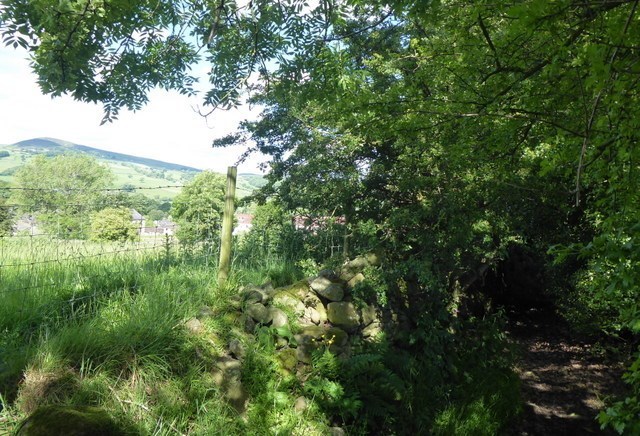 The western part of the hollow lane (where the cache is located) has tumbled medieval walls with some sections of more substantial dry-stone wall dating from around 1550.
Looking up into The South Field which lies to the south beyond the gate near the cache, you will see a narrow strip of field between broken rows of large trees. In the past, individual villagers cultivated their own narrow strips which were unfenced and the strip that survives was separately enclosed by hedges in the 16th century.
The left-hand stone gate post is 19th century but the right-hand one is much older.
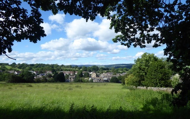
Original wording [+ added notes]:'This is a good place to look back at the village and its setting.
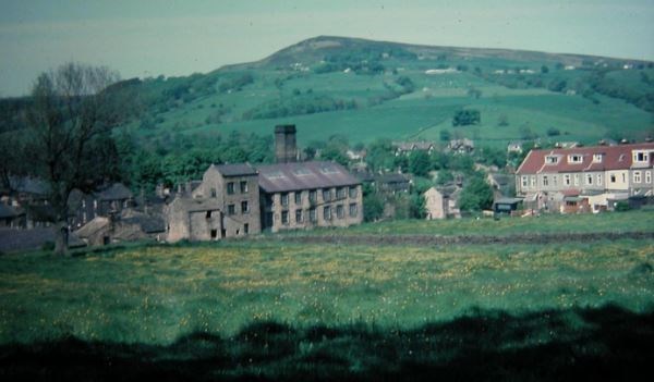
Beamsley Beacon is prominent [some 4km to the north-east] across the [Wharfe] valley in the distance and the former Burnside Mill (built in 1886) is just below the field to the right (now converted into flats). Roofs of old buildings along the Main St can be seen, with newer housing beyond and many farm fields on the slopes, some reaching almost to the village centre. Some field boundaries consist of hedges and trees, others, such as the one here next to the path are made of dry-stone walls.
Over the centuries the village has changed from a small farming community centred on Sugar Hill [just north of Main St, opposite the Post Office] in medieval times, to the industrial village of 'Long Addingham', with its weaving sheds, textile mills, workers housing, shops, and pubs. These were mainly built in the 19th century filling in the spaces between the old farmsteads, barns and cottages along Main Street & Church Street [on the east side of the village].
The old buildings used local stone - Millstone Grit- for both walls and roofing slates although with the 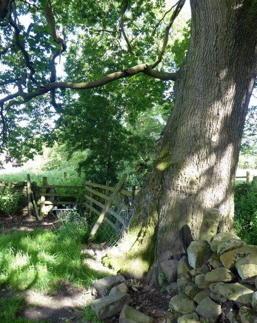 building of canals and railways it was easier to bring in material from elsewhere and so Welsh slate started to be used as a cheaper, easier roofing material rather than the traditional large heavy millstone grit slates.
The footpath you have just walked up is a very old path [heading up through Great Meadow]. Before the age of cars it would have been the main route into the village for those living on farms on the [Addingham] Moorside. [These fields are the site of Addingham's large medieval open strip-farmed arable fields. Today the hedgerows of the long narrow fields represent former edges of the old ploughed strips].
In the north-west corner of the field next to the one you're standing in [thought to be @ N 53 56.648 W 1 53.370] there is [a small depression in the ground and] an old shed (hidden in summer by the leaves of an ash tree) called the 'Coal pit building'. This is where in 1845 a group led by Thomas Lister unsuccessful tried to find coal by sinking a deep shaft, now filled in, into the ground. [With increasing mechanisation of industry there was then a growing demand for coal to power steam engines to work the textile mills, and also for domestic use].
The prospectors had little geological understanding - workable coal seams do not occur in the rocks below Addingham but in younger rocks found to the east. [Here, they had hoped to make their fortune but they found only 'stone and shale' and they 'were forced to give over in consequence of poverty'].