Notice: "Cache seekers assume all risks and responsibilities involved in seeking this earthcache."
Warning: This is an agricultural area where many long-haul trucks full of wheat, corn, onions, potatoes, carrots, sugar beets and other commodities are busy going down the road. Most of us locals are accustomed to these trucks. If you don’t feel safe or comfortable stopping alongside the road or in a pullout to observe the geology, “Don’t Stop”. Don’t let earthcaching control you, but rather you control earthcaching. “Just because it is there, doesn’t mean you have to stop!”
“For your safety, even though the shoulder may be wide enough to stop and make observations, please park in the designated parking pullout and walk to the final. The road does get busy at times. If you feel uncomfortable with the suggested parking location, find a wider spot down the road and walk back.”
***Note: Beyond road right of way is private property***
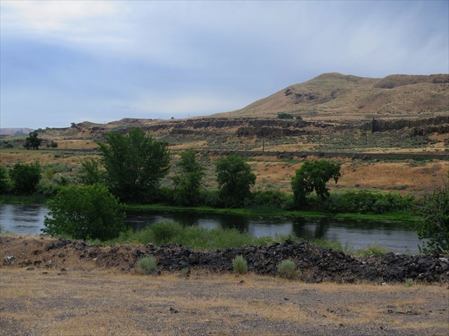
Yakima River Badlands
Between Benton City and Prosser, Washington are the Yakima River Badlands. The Yakima Valley narrows between Chandler Butte Ridge/Reach at the northern edge of the Horse Heaven Hills to the south and Rattlesnake Mountain/Ridge to the north.

Yakima River Badlands: Rock Benches
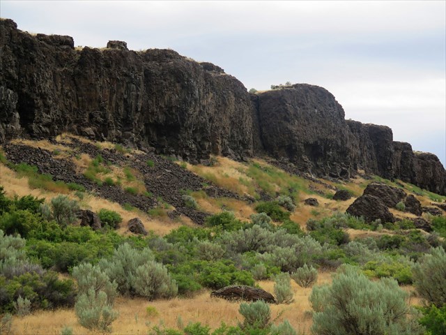
Rock benches are called structural benches by geologist. These benches are narrow strips of land cut by erosion leaving a distinct cliff on one or both sides. Think of an open pit mine with a haul road cut into the wall/batter that goes around and around the pit to the top. The road itself is the bench. It is not the cliff.
Across the Yakima River to the south from the road pullout, at least two distinct benches can be observed. The top bench begins at the base of Chandler Butte and continues to the crest of the upper cliff. This bench is about a quarter mile wide. The cliff varies in height from 30 to 60 feet. The middle bench fluctuates between 300 to 600 feet wide. From the toe/base of the bottom cliff to the river is another quarter mile. These benches are filled with Quaternary/most recent sediment flood deposits.
This earthcache places the finder on a 300 foot wide bench on the north side of the Yakima River with an eroded but intact basalt cliff above and a disintegrating cliff below.
Inland Empire Highway: Rock Bench
Go back 6 million years ago and the earthcacher would be standing on the last layer of a volcanic lava flood known as the Saddle Mountain basalt formation. The basalt below averages 500 feet deep. Below it are a hundred lava floods, thousands of feet deep, and is all part of the Columbia Basin Basalt Group. The last flow is only 1% of the total. The Yakima River was not here either. The river was pushed east to where it runs now because of the Anticline uplift of the Cascade Mountains and the Yakima Fold Belt. Sandwiched between parts of the Yakima fold which include the Horse Heaven Hills to the south and Rattlesnake Mountains to the north, the valley dropped called a Syncline is where the river cut its channel. The channel erosion was helped immensely by the Missoula Floods 13,000 years ago. The waters rushed up the river valley and hit the constriction of the narrowed valley. The force blasted out and cut away at the basalt leaving the exposed basalt cliffs and benches.
To log this Earthcache,
Please send a private message to me with answers to the following questions.
1. Summarize the factors which created the Yakima River rock benches?
2. On the bench you are standing, there are very large conglomerate basalt blocks. Did they break of the cliff or are they part of the underlying basalt?
3. Looking north to northeast, you will observe the thick upper rubbly crust and below several bands of larger columnar blocks of the cliff’s face. There are many cracks, holes and undercuts. What do you think is the principle erosion at work on the cliff?
Optional: Upload a photo to the page of local wildlife, unique vegetation or geology in the area.
For addition information, visit:
Extent and Depth to Top of Basalt and Interbed Hydrogeologic Units, Yakima River Basin Aquifer System, Washington
Hug Flood
Reference Guild Book:
Bjornstad, Bruce. On the Trail of the Ice Age Floods: a Geological Field Guide to the Mid-Columbia Basin. Keokee Co. Pub., 2011.